Mapa geològic
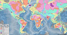

Un mapa geològic és un mapa que té la intenció especial de mostrar les característiques geològiques. Les roques o estrats geològics es mostren mitjançant colors o símbols per a indicar on estan exposats a la superfície. Les planes i les característiques estructurals com la falles geològiques els plegaments, les foliacions i les alineacions es mostren amb símbols de ratlles i/o punts per a donar orientacions en tres dimensions.
Història
El mapa geològic més antic que es conserva és el del Papir de Torí (1150 aC.), que mostra la localització de pedra per a la construcció i de jaciments d'or a Egipte.[1]
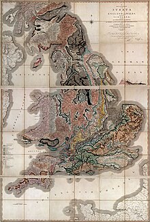
El primer mapa geològic dels Estats Units el va fer William Maclure el 1809.[2][3] El primer mapa geològic de la Gran Bretanya el va confeccionar William Smith el 1815.[4]
Referències
- ↑ Harrell, James A.; Brown, V. Max «The world's oldest surviving geological map—the 1150 BC Turin papyrus from Egypt». Journal of Geology, 100, 1, 1992, pàg. 3–18. JSTOR: 30082315.
- ↑ William Maclure. Observations on the Geology of the United States of America: With Some Remarks on the Effect Produced on the Nature and Fertility of Soils, by the Decomposition of the Different Classes of Rocks; and an Application to the Fertility of Every State in the Union, in Reference to the Accompanying Geological Map ..., 1817.
- ↑ Observations on the Geology of the United States (Maclure) - David Rumsey map collection
- ↑ Simon Winchester, 2002, The Map that Changed the World, Harper-Collins ISBN 0-06-093180-9
Enllaços externs
- IGME 5000 International Geological Map of Europe and Adjacent Areas Arxivat 2015-11-25 a Wayback Machine. 1:5.000.000, Asch, K (2005), Bundesanstalt für Geowissenschaften und Rohstoffe (BGR), Hannover
- Geology of Britain viewer Arxivat 2016-12-02 a Wayback Machine. from the British Geological Survey, at 1:50,000 and 1:625,000 scales
- Geologic Maps Arxivat 2004-11-23 a Wayback Machine. from USGS National Park Service
- USGS National Geologic Map Database
