Friauville
| Friauville | ||
|---|---|---|
 |
| |
| Staat | Frankreich | |
| Region | Grand Est | |
| Département (Nr.) | Meurthe-et-Moselle (54) | |
| Arrondissement | Val-de-Briey | |
| Kanton | Jarny | |
| Gemeindeverband | Orne Lorraine Confluences | |
| Koordinaten | 49° 9′ N, 5° 51′ O49.1463888888895.8422222222222Koordinaten: 49° 9′ N, 5° 51′ O | |
| Höhe | 187–221 m | |
| Fläche | 6,34 km² | |
| Einwohner | 373 (1. Januar 2021) | |
| Bevölkerungsdichte | 59 Einw./km² | |
| Postleitzahl | 54800 | |
| INSEE-Code | 54213 | |
| Website | www.friauville.fr | |


Vorlage:Infobox Gemeinde in Frankreich/Wartung/abweichendes Wappen in Wikidata
Friauville ist eine französische Gemeinde mit 373 Einwohnern (Stand 1. Januar 2021) im Département Meurthe-et-Moselle in der Region Grand Est (vor 2016 Lothringen). Sie gehört zum Arrondissement Val-de-Briey und ist Mitglied im Gemeindeverband Communauté de communes Orne Lorraine Confluences. Die Einwohner werden Friauvillois(es) genannt.
Geografie
Die Gemeinde Friauville liegt am Longeau, etwa 25 Kilometer westlich von Metz. Nachbargemeinden sind Boncourt im Norden, Conflans-en-Jarnisy im Norden und Nordosten, Jarny im Osten und Südosten, Brainville im Süden, Allamont im Südwesten und Westen sowie Puxe im Nordwesten.
Geschichte
Friauville gehörte historisch zum Herzogtum Bar, das 1766 an Frankreich fiel. Bis zur Französischen Revolution lag der Ort dann im Grand-gouvernement de Lorraine-et-Barrois. Die Gemeinde lag bis 1871 im alten Département Moselle.
Bevölkerungsentwicklung
| Jahr | 1793 | 1841 | 1962 | 1968 | 1975 | 1982 | 1990 | 1999 | 2007 | 2019 |
| Einwohner | 301 | 360 | 223 | 224 | 195 | 151 | 225 | 264 | 342 | 367 |
| Quellen: Cassini und INSEE | ||||||||||
Sehenswürdigkeiten
- Mehrere Bauernhäuser aus dem 18. und 19. Jahrhundert in der Grande Rue
- Pfarrkirche Saint-Vanne, errichtet 1860 als Neubau
- Kapelle La Hayotte aus dem 19./20. Jahrhundert
- Pfarrhaus aus dem 18. Jahrhundert und weitere alte Häuser im Dorfzentrum
- Denkmal für die Gefallenen[1]
-
 Pfarrkirche Saint-Vanne
 -
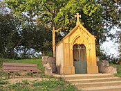 Kapelle La Hayotte


Persönlichkeiten
- Anthony Janiec (1984–2022), französischer Truck- und Automobilrennfahrer, geboren in Friauville
Einzelnachweise
- ↑ Denkmal für die Gefallenen
Weblinks
Commons: Friauville – Sammlung von Bildern
- Fotos der Dorfkirche und der Kapelle


