Arâches-la-Frasse
You can help expand this article with text translated from the corresponding article in French. (February 2014) Click [show] for important translation instructions.
- View a machine-translated version of the French article.
- Machine translation, like DeepL or Google Translate, is a useful starting point for translations, but translators must revise errors as necessary and confirm that the translation is accurate, rather than simply copy-pasting machine-translated text into the English Wikipedia.
- Do not translate text that appears unreliable or low-quality. If possible, verify the text with references provided in the foreign-language article.
- You must provide copyright attribution in the edit summary accompanying your translation by providing an interlanguage link to the source of your translation. A model attribution edit summary is
Content in this edit is translated from the existing French Wikipedia article at [[:fr:Arâches-la-Frasse]]; see its history for attribution. - You may also add the template
{{Translated|fr|Arâches-la-Frasse}}to the talk page. - For more guidance, see Wikipedia:Translation.
Commune in Auvergne-Rhône-Alpes, France

Coat of arms
Location of Arâches-la-Frasse

(2023–2026) Alexandra Fourgeaud[1]
1
(2021)[2]
74014 /74300
Arâches-la-Frasse (French pronunciation: [aʁaʃ la fʁas]) is commune in the Haute-Savoie department in the Auvergne-Rhône-Alpes region in south-eastern France.
Situated in the northern French Alps, the commune sits on a large sunny plateau overlooking the Arve Valley southeast of the town of Cluses.
It is part of the canton of Sallanches. The main villages in the commune are Arâches, Les Carroz, and La Frasse.
Les Carroz

Until the 1930s the village of Les Carroz was a simple farming hamlet with only a few houses. It is now developing into the nearest large ski resort to Geneva. By 1981 Les Carroz had been linked to the nearby ski villages of Samoëns, Morillon and Sixt-Fer-à-Cheval, and the resort of Flaine, developed in the 1960s. The Grand-Massif ski area had been born. The gondola and chairlift in Les Carroz can take skiers straight up to the extensive skiing in the Grand Massif.[3]
Gallery
-
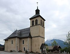 Church
 -
 Chapel
 -
 Mission cross
 -
 War memorial
 -
 Fountain


See also
References
- ^ "Répertoire national des élus: les maires" (in French). data.gouv.fr, Plateforme ouverte des données publiques françaises. 30 November 2023.
- ^ "Populations légales 2021". The National Institute of Statistics and Economic Studies. 28 December 2023.
- ^ "GrandMassif.co.uk".
External links
Wikimedia Commons has media related to Arâches-la-Frasse.
- Les Carroz webcam: http://www.grandmassif.co.uk
- v
- t
- e
- Abondance
- Alby-sur-Chéran
- Alex
- Allèves
- Allinges
- Allonzier-la-Caille
- Amancy
- Ambilly
- Andilly
- Annecypref
- Annemasse
- Anthy-sur-Léman
- Arâches-la-Frasse
- Arbusigny
- Archamps
- Arenthon
- Argonay
- Armoy
- Arthaz-Pont-Notre-Dame
- Ayse
- Ballaison
- La Balme-de-Sillingy
- La Balme-de-Thuy
- Bassy
- La Baume
- Beaumont
- Bellevaux
- Bernex
- Le Biot
- Bloye
- Bluffy
- Boëge
- Bogève
- Bonne
- Bonnevaux
- Bonnevillesubpr
- Bons-en-Chablais
- Bossey
- Le Bouchet-Mont-Charvin
- Boussy
- Brenthonne
- Brizon
- Burdignin
- Cercier
- Cernex
- Cervens
- Chainaz-les-Frasses
- Challonges
- Chamonix-Mont-Blanc
- Champanges
- La Chapelle-d'Abondance
- La Chapelle-Rambaud
- La Chapelle-Saint-Maurice
- Chapeiry
- Charvonnex
- Châtel
- Châtillon-sur-Cluses
- Chaumont
- Chavannaz
- Chavanod
- Chêne-en-Semine
- Chênex
- Chens-sur-Léman
- Chessenaz
- Chevaline
- Chevenoz
- Chevrier
- Chilly
- Choisy
- Clarafond-Arcine
- Les Clefs
- Clermont
- La Clusaz
- Cluses
- Collonges-sous-Salève
- Combloux
- Contamine-Sarzin
- Les Contamines-Montjoie
- Contamine-sur-Arve
- Copponex
- Cordon
- Cornier
- La Côte-d'Arbroz
- Cranves-Sales
- Crempigny-Bonneguête
- Cruseilles
- Cusy
- Cuvat
- Demi-Quartier
- Desingy
- Dingy-en-Vuache
- Dingy-Saint-Clair
- Domancy
- Doussard
- Douvaine
- Draillant
- Droisy
- Duingt
- Éloise
- Entrevernes
- Épagny Metz-Tessy
- Essert-Romand
- Etaux
- Étercy
- Étrembières
- Évian-les-Bains
- Excenevex
- Faucigny
- Faverges-Seythenex
- Feigères
- Fessy
- Féternes
- Fillière
- Fillinges
- La Forclaz
- Franclens
- Frangy
- Gaillard
- Les Gets
- Giez
- Glières-Val-de-Borne
- Le Grand-Bornand
- Groisy
- Gruffy
- Habère-Lullin
- Habère-Poche
- Hauteville-sur-Fier
- Héry-sur-Alby
- Les Houches
- Jonzier-Épagny
- Juvigny
- Larringes
- Lathuile
- Leschaux
- Loisin
- Lornay
- Lovagny
- Lucinges
- Lugrin
- Lullin
- Lully
- Lyaud
- Machilly
- Magland
- Manigod
- Marcellaz
- Marcellaz-Albanais
- Margencel
- Marignier
- Marigny-Saint-Marcel
- Marin
- Marlioz
- Marnaz
- Massingy
- Massongy
- Maxilly-sur-Léman
- Megève
- Mégevette
- Meillerie
- Menthonnex-en-Bornes
- Menthonnex-sous-Clermont
- Menthon-Saint-Bernard
- Mésigny
- Messery
- Mieussy
- Minzier
- Monnetier-Mornex
- Montagny-les-Lanches
- Montriond
- Mont-Saxonnex
- Morillon
- Morzine
- Moye
- La Muraz
- Mûres
- Musièges
- Nancy-sur-Cluses
- Nangy
- Nâves-Parmelan
- Nernier
- Neuvecelle
- Neydens
- Nonglard
- Novel
- Onnion
- Orcier
- Passy
- Peillonnex
- Perrignier
- Pers-Jussy
- Poisy
- Praz-sur-Arly
- Présilly
- Publier
- Quintal
- Reignier-Esery
- Le Reposoir
- Reyvroz
- La Rivière-Enverse
- La Roche-sur-Foron
- Rumilly
- Saint-André-de-Boëge
- Saint-Blaise
- Saint-Cergues
- Saint-Eusèbe
- Saint-Eustache
- Saint-Félix
- Saint-Ferréol
- Saint-Germain-sur-Rhône
- Saint-Gervais-les-Bains
- Saint-Gingolph
- Saint-Jean-d'Aulps
- Saint-Jean-de-Sixt
- Saint-Jean-de-Tholome
- Saint-Jeoire
- Saint-Jorioz
- Saint-Julien-en-Genevoissubpr
- Saint-Laurent
- Saint-Paul-en-Chablais
- Saint-Pierre-en-Faucigny
- Saint-Sigismond
- Saint-Sixt
- Saint-Sylvestre
- Sales
- Sallanches
- Sallenôves
- Samoëns
- Le Sappey
- Savigny
- Saxel
- Scientrier
- Sciez
- Scionzier
- Serraval
- Servoz
- Sevrier
- Seyssel
- Seytroux
- Sillingy
- Sixt-Fer-à-Cheval
- Talloires-Montmin
- Taninges
- Thollon-les-Mémises
- Thônes
- Thonon-les-Bainssubpr
- Thusy
- Thyez
- La Tour
- Usinens
- Vacheresse
- Vailly
- Val-de-Chaise
- Valleiry
- Vallières-sur-Fier
- Vallorcine
- Vanzy
- Vaulx
- Veigy-Foncenex
- Verchaix
- La Vernaz
- Vers
- Versonnex
- Vétraz-Monthoux
- Veyrier-du-Lac
- Villard
- Les Villards-sur-Thônes
- Villaz
- Ville-en-Sallaz
- Ville-la-Grand
- Villy-le-Bouveret
- Villy-le-Pelloux
- Vinzier
- Viry
- Viuz-en-Sallaz
- Viuz-la-Chiésaz
- Vougy
- Vovray-en-Bornes
- Vulbens
- Yvoire
- pref: prefecture
- subpr: subprefecture
Authority control databases | |
|---|---|
| International |
|
| National |
|
| Geographic |
|
 | This Haute-Savoie geographical article is a stub. You can help Wikipedia by expanding it. |
- v
- t
- e


