Baisieux
Commune in Hauts-de-France, France

Coat of arms
Location of Baisieux

(2020–2026) Philippe Limousin[1]
1
(2021)[2]
59044 /59780
(avg. 28 m or 92 ft)
Baisieux (French pronunciation: [bɛzjø]) is a commune in the Nord department, northern France. It is part of the Métropole Européenne de Lille.[3]
Population
|
| ||||||||||||||||||||||||||||||||||||||||||||||||||||||
| Source: EHESS[4] and INSEE (1968-2017)[5] | |||||||||||||||||||||||||||||||||||||||||||||||||||||||
Heraldry
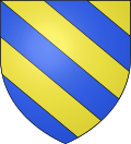 | The arms of Baisieux are blazoned : Bendy Or and azure. (Baisieux, Bouvines and Cysoing use the same arms.)
|
See also
References
- ^ "Répertoire national des élus: les maires" (in French). data.gouv.fr, Plateforme ouverte des données publiques françaises. 13 September 2022.
- ^ "Populations légales 2021". The National Institute of Statistics and Economic Studies. 28 December 2023.
- ^ INSEE commune file
- ^ Des villages de Cassini aux communes d'aujourd'hui: Commune data sheet Baisieux, EHESS (in French).
- ^ Population en historique depuis 1968, INSEE
Wikimedia Commons has media related to Baisieux.
- v
- t
- e
Communes of the Métropole Européenne de Lille 

- Allennes-les-Marais
- Annœullin
- Anstaing
- Armentières
- Aubers
- Baisieux
- La Bassée
- Bauvin
- Beaucamps-Ligny
- Bois-Grenier
- Bondues
- Bousbecque
- Bouvines
- Capinghem
- Carnin
- La Chapelle-d'Armentières
- Chéreng
- Comines
- Croix
- Deûlémont
- Don
- Emmerin
- Englos
- Ennetières-en-Weppes
- Erquinghem-le-Sec
- Erquinghem-Lys
- Escobecques
- Faches-Thumesnil
- Forest-sur-Marque
- Fournes-en-Weppes
- Frelinghien
- Fretin
- Fromelles
- Gruson
- Hallennes-lez-Haubourdin
- Halluin
- Hantay
- Haubourdin
- Hem
- Herlies
- Houplin-Ancoisne
- Houplines
- Illies
- Lambersart
- Lannoy
- Le Maisnil
- Leers
- Lesquin
- Lezennes
- Lille (includes the associate-communes of Hellemmes and Lomme)
- Linselles
- Lompret
- Loos
- Lys-lez-Lannoy
- La Madeleine
- Marcq-en-Barœul
- Marquette-lez-Lille
- Marquillies
- Mons-en-Barœul
- Mouvaux
- Neuville-en-Ferrain
- Noyelles-lès-Seclin
- Pérenchies
- Péronne-en-Mélantois
- Prémesques
- Provin
- Quesnoy-sur-Deûle
- Radinghem-en-Weppes
- Ronchin
- Roncq
- Roubaix
- Sailly-lez-Lannoy
- Sainghin-en-Mélantois
- Sainghin-en-Weppes
- Saint-André-lez-Lille
- Salomé
- Santes
- Seclin
- Sequedin
- Templemars
- Toufflers
- Tourcoing
- Tressin
- Vendeville
- Verlinghem
- Villeneuve-d'Ascq
- Wambrechies
- Warneton
- Wasquehal
- Wattignies
- Wattrelos
- Wavrin
- Wervicq-Sud
- Wicres
- Willems
| Authority control databases: National |
|
|---|
 | This Nord geographical article is a stub. You can help Wikipedia by expanding it. |
- v
- t
- e


