Chandra Taal
Lake in Himachal Pradesh, India
32°28′31″N 77°37′01″E / 32.47518°N 77.61706°E / 32.47518; 77.61706
Ramsar Wetland
Chandra Taal (lit. 'moon lake') is a lake in the upper Chandra valley of the Lahul and Spiti district of Himachal Pradesh, India.[1] Chandra Taal is near the source of the Chandra River. Despite the rugged and inhospitable surroundings, it is in a protected niche with some flowers and wildlife in summer. It is a favourite spot for tourists and high-altitude trekkers. It is usually associated with Spiti, although geographically it lies in the watershed of the Chandra River of Lahaul. Kunzum La separates Lahaul and Spiti valleys.
Description
Chandra Taal Lake is on the Samudra Tapu plateau, which overlooks the Chandra River (a source river of the Chenab). The name of the lake originates from its crescent shape. It is at an altitude of about 4,300 metres (14,100 ft) in the Himalayas.[1] Mountains of scree overlook the lake on one side, and a cirque encloses it on the other.
Access

Chandra Taal is a tourist destination for trekkers and campers. The lake is accessible by road from Batal and by road as well as on foot from Kunzum Pass from late May to early October. The road to Chandra Taal branches off from NH-505 about 2.9 kilometres (1.8 mi) from Batal and 8 km (5.0 mi) from Kunzum Pass.[3] This 12 km (7.5 mi) motor road runs as far as a parking lot 1 kilometre (0.62 mi) from the lake. One has to travel on foot for the final 1 kilometre1 km (0.62 mi). It takes approximately two hours from Kunzum Pass to Chandra Taal. Chandra Taal is also accessible from Suraj Tal, 30 km (19 mi) away.
Fauna and flora

There are vast meadows on the banks of the lake. During springtime, these meadows are carpeted with hundreds of varieties of wild flowers.[4] In 1871, Harcourt, Assistant Commissioner of Kullu, reported that there was a plain of good grass to the north of Chadra Taal, where shepherds brought large herds for grazing from Kullu and Kangra.[5] Due to overgrazing, the grasslands are now degraded.[2]

Chandra Taal is home to a few species such as the Snow Leopard, Snow Cock, Chukor, Black Ring Stilt, Kestrel, Golden Eagle, Chough, Red Fox, Himalayan Ibex, and Blue Sheep. Over time, these species have adapted to the cold arid climate, intense radiation, and oxygen deficiency by developing special physiological features. Migratory species such as the Ruddy shelduck are found in summer.[6]
Other details
The lake is one of two high-altitude wetlands of India which have been designated as Ramsar sites. Tourism seems to be having its effect on this pristine hidden paradise.[2]
Gallery
-
 Chander Taal Wildlife Sanctuary sign. Lahaul & Spiti.
 -
 View of Chandra Taal, 2008
 -
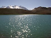
 Chandra Taal
 -
 Chandra Taal reflecting evening sun
 -
 Footpath around the lake, Jul 2017
 -
 Ruddy shelduck & wildflowers, Jun 2018
 -
 Wildflowers, Jun 2018
 -
 Grass flowers by the lake, Jun 2018


References
- ^ a b c d "Official Website of Lahaul & Spiti District, Himachal Pradesh, India". Deputy Commissioner, Lahaul and Spiti. Retrieved 28 March 2017.
- ^ a b c "Chandertal Wetland". Ramsar Sites Information Service. Retrieved 25 April 2018.
- ^ "Route from NH-505 to Chandra Taal". OpenStreetMap.org. Retrieved 26 September 2020.
- ^ "Photographs of Chandratal Lake, Lahaul & Spiti Himalayas". Darter Photography. 20 June 2014. Retrieved 27 August 2019.
- ^ Harcourt, A.F.P. (1871). The Himalayan Districts of Kooloo, Lahoul and Spiti. London: W.H. Allen & Sons. pp. 16–21.
- ^ Ali, Salim; et al. (Bombay Natural History Society) (2012). The Book of Indian Birds (13th ed.). Oxford University Press. p. 83. ISBN 0195665236.
External links
- Chandra Taal photos on Trek Earth
- Trekking map Archived 22 July 2011 at the Wayback Machine
- Hampta Pass Chandratal Trek Archived 13 May 2020 at the Wayback Machine
- v
- t
- e
- Ladakh
- Leh–Manali Highway
- Manali, Himachal Pradesh
- Chandra Taal
- Suraj Tal


