Church Point, New South Wales
Suburb of Sydney, New South Wales, Australia
| Church Point Sydney, New South Wales | |||||||||||||||
|---|---|---|---|---|---|---|---|---|---|---|---|---|---|---|---|
 Church Point Post Office | |||||||||||||||
 Church Point | |||||||||||||||
| Population | 1,066 (SAL 2021)[1] | ||||||||||||||
| Postcode(s) | 2105 | ||||||||||||||
| Elevation | 12 m (39 ft) | ||||||||||||||
| Area | 0.7 km2 (0.3 sq mi) | ||||||||||||||
| Location | 32 km (20 mi) N of Sydney CBD | ||||||||||||||
| LGA(s) | Northern Beaches Council | ||||||||||||||
| State electorate(s) | Pittwater | ||||||||||||||
| Federal division(s) | Mackellar | ||||||||||||||
| |||||||||||||||
Church Point is a suburb in the Northern Beaches region of Sydney, in the state of New South Wales, Australia. Church Point is 32 kilometres north of the Sydney central business district, in the local government area of Northern Beaches Council.
History
Thomas Langford was the first settler in the area who acquired 40 acres (160,000 m2) in 1852. The area was originally known as Chapel Point because it was the site of a Wesleyan Chapel built in 1872 on land given by William Oliver.[2]
Early Subdivision Plans
-
 Church Point Estate Pittwater – Quarter Session Rd, Lane Cove, 1909
 -
 Church Point "Browns Block" Pittwater – Browns Rd, Quarter Session Rd, Bay View Rd, 1920
 -
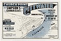 Simpson's Garden Estate Church Point Pittwater – Baroona Rd, Bay View Rd, Eastview Road, 1921


Demographics
According to the 2021 census, there were 1,066 residents in Church Point. The most common ancestries in Church Point were English 47.5%, Australian 28.8%, Irish 13.5%, Scottish 13.3% and German 4.4%. 63.0% of people were born in Australia, the next most common countries of birth were England at 12.2%, the United States of America 2.3%, New Zealand 2.2%, South Africa 2.0%, and Scotland 1.2%. 88.6% of people spoke only English at home with the next most common languages spoken at home being Mandarin 1.6%, German 0.7%, Slovak 0.5%, Spanish 0.4%, and Russian 0.4%. The most common responses for religion in Church Point were No Religion 45.9%, Anglican 19.2%, Catholic 13.7, and Uniting Church 2.7%; a further 7.4% of respondents elected not to disclose their religion.[3]
The median weekly household income was $3,182, much higher than the national median of $1,746. Average monthly mortgage payments were $3,600, compared to the national average of $1,863.[3]
Transport
Pittwater Road is Church Point's main thoroughfare and ends in the suburb.
The Church Point ferry wharf is in McCarrs Creek Road near the post office from where the Church Point Ferry service departs to Scotland Island, Pittwater Youth Hostel, Lovett Bay and Elvina Bay.
References
- ^ Australian Bureau of Statistics (28 June 2022). "Church Point (suburb and locality)". Australian Census 2021 QuickStats. Retrieved 28 June 2022.

- ^ The Book of Sydney Suburbs, Compiled by Frances Pollon, Angus & Robertson Publishers, 1990, Published in Australia ISBN 0-207-14495-8, page 62
- ^ a b Australian Bureau of Statistics (28 June 2022). "Church Point". 2021 Census QuickStats. Retrieved 9 June 2024.
External links
Wikimedia Commons has media related to Church Point, New South Wales.
33°39′16″S 151°16′45″E / 33.6544°S 151.2791°E / -33.6544; 151.2791
- v
- t
- e
Suburbs of Northern Beaches Council, Sydney
- Allambie Heights
- Avalon Beach
- Balgowlah
- Balgowlah Heights
- Bayview
- Beacon Hill
- Belrose
- Bilgola Beach
- Bilgola Plateau
- Brookvale
- Church Point
- Clareville
- Clontarf
- Coasters Retreat
- Collaroy
- Collaroy Plateau
- Cottage Point
- Cromer
- Curl Curl
- Currawong Beach
- Davidson
- Dee Why
- Duffys Forest
- Elanora Heights
- Elvina Bay
- Fairlight
- Forestville
- Frenchs Forest
- Freshwater
- Great Mackerel Beach
- Ingleside
- Killarney Heights
- Lovett Bay
- Manly
- Manly Vale
- McCarrs Creek
- Mona Vale
- Morning Bay
- Narrabeen
- Narraweena
- Newport
- North Balgowlah
- North Curl Curl
- North Manly
- North Narrabeen
- Oxford Falls
- Palm Beach
- Queenscliff
- Salt Pan Cove
- Scotland Island
- Seaforth
- Terrey Hills
- Warriewood
- Whale Beach
- Wheeler Heights
Hawkesbury River region, New South Wales, Australia | |||||||||
|---|---|---|---|---|---|---|---|---|---|
| Islands | |||||||||
| National parks and nature reserves | |||||||||
| European explorers of the region | |||||||||
| Bridges and ferries |
| ||||||||
| Adjoining rivers, bays, reservoirs, and creeks |
| ||||||||
| Local government areas |
| ||||||||
| Education |
| ||||||||
| Major attractions | |||||||||
| |||||||||

 | This article related to the geography of Sydney is a stub. You can help Wikipedia by expanding it. |
- v
- t
- e


