DD postcode area
Postcode area within the United Kingdom
56°32′35″N 2°51′18″W / 56.543°N 2.855°W / 56.543; -2.855
DD
Dundee
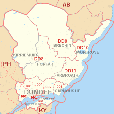
The DD postcode area, also known as the Dundee postcode area,[2] is a group of eleven postcode districts in eastern Scotland, within nine post towns. These cover Dundee and Angus (including Forfar, Arbroath, Brechin, Carnoustie, Kirriemuir and Montrose), plus part of north-east Fife (including Newport-on-Tay and Tayport) and small parts of Perth and Kinross and Aberdeenshire.
Coverage
The approximate coverage of the postcode districts:
| Postcode district | Post town | Coverage | Local authority area(s) |
|---|---|---|---|
| DD1 | DUNDEE | Most of the city centre, the University and the Riverside | Dundee |
| DD2 | DUNDEE | The West of the city including Lochee, Blackness, Ninewells, Menzieshill, Charleston, Balgay, Ardler and Logie | Dundee, Perth and Kinross |
| DD3 | DUNDEE | The northwest of the city including St Marys, Downfield and Kirkton, and the inner city areas of Strathmartine, Coldside and the Hilltown | Dundee, Angus |
| DD4 | DUNDEE | The inner city area of Stobswell and Craigie, and the northeast of the city including Pitkerro, Douglas, Fintry and Whitfield | Dundee, Angus |
| DD5 | DUNDEE | The east of the city including Broughty Ferry, Barnhill and Monifieth | Dundee, Angus |
| DD6 | NEWPORT-ON-TAY | Newport-on-Tay, Wormit, Balmerino, Gauldry | Fife |
| TAYPORT | Tayport | ||
| DD7 | CARNOUSTIE | Carnoustie | Angus |
| DD8 | FORFAR | Forfar, Glamis, Letham | Angus |
| KIRRIEMUIR | Kirriemuir | ||
| DD9 | BRECHIN | Brechin, Edzell | Angus |
| DD10 | MONTROSE | Montrose, St Cyrus, Inverbervie, Hillside, Gourdon | Angus, Aberdeenshire |
| DD11 | ARBROATH | Arbroath, Friockheim | Angus |
Map
KML file (edit • help)
Template:Attached KML/DD postcode area
KML is from Wikidata
See also
References
- ^ "ONS Postcode Directory Version Notes" (ZIP). National Statistics Postcode Products. Office for National Statistics. May 2020. Table 2. Retrieved 19 June 2020. Coordinates from mean of unit postcode points, "Code-Point Open". OS OpenData. Ordnance Survey. February 2012. Retrieved 21 April 2012.
- ^ Royal Mail, Address Management Guide, (2004)
External links
- Royal Mail's Postcode Address File
- A quick introduction to Royal Mail's Postcode Address File (PAF)
- v
- t
- e
- AB
- AL
- B
- BA
- BB
- BD
- BH
- BL
- BN
- BR
- BS
- BT
- CA
- CB
- CF
- CH
- CM
- CO
- CR
- CT
- CV
- CW
- DA
- DD
- DE
- DG
- DH
- DL
- DN
- DT
- DY
- E
- EC
- EH
- EN
- EX
- FK
- FY
- G
- GL
- GU
- HA
- HD
- HG
- HP
- HR
- HS
- HU
- HX
- IG
- IP
- IV
- KA
- KT
- KW
- KY
- L
- LA
- LD
- LE
- LL
- LN
- LS
- LU
- M
- ME
- MK
- ML
- N
- NE
- NG
- NN
- NP
- NR
- NW
- OL
- OX
- PA
- PE
- PH
- PL
- PO
- PR
- RG
- RH
- RM
- S
- SA
- SE
- SG
- SK
- SL
- SM
- SN
- SO
- SP
- SR
- SS
- ST
- SW
- SY
- TA
- TD
- TF
- TN
- TQ
- TR
- TS
- TW
- UB
- W
- WA
- WC
- WD
- WF
- WN
- WR
- WS
- WV
- YO
- ZE
- Related UK lists: Postcode districts
- Post towns
- Postal counties
- London postal district