Egmating
Municipality in Bavaria, Germany

Coat of arms
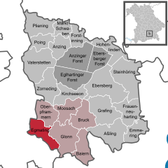
Location of Egmating within Ebersberg district
(2020–26) Ingeborg Heiler[1]
(2022-12-31)[2]
85658
Egmating is a community in the Upper Bavarian district of Ebersberg in Germany. It is a member of the administrative community (Verwaltungsgemeinschaft) of Glonn.
Geography
Egmating lies in the Munich region. It includes one traditional rural land unit – Gemarkung in German – also called Egmating.
The constituent communities of Orthofen, Neuorthofen, Lindach, Münster und Neumünster are to be found within Egmating.
History
Egmating belonged to the Lord (Freiherr) of Hornstein. It was part of the Electorate of Bavaria and was a lordly estate.
Population development
The community’s land area was home to 1,180 inhabitants in 1970, 1,388 in 1987 and 1,639 in 2000.
Politics
The community's mayor (Bürgermeister) is Ingeborg Heiler (Aktive Bürgerliste Egmating).
The community's tax revenue in 1999, converted into euros, was €765,000, of which €45,000 was from business taxes.
Economy and infrastructure
In 1998, according to official statistics, the field of industry employed 25 workers on the social insurance contribution rolls. In transport and trade, however, there were none. Also, 547 people on the aforesaid rolls worked from their homes, and 77 were employed in other fields. There were four processing businesses. There were five businesses in contracting. Furthermore, in 1999, there were 38 agricultural businesses with a total productive land area of 744 ha, of which 494 ha was meadowland.
Education
In 1999, the following institutions could be found in Egmating:
- Kindergartens: 50 Kindergarten places with 42 children
References
- ^ Liste der ersten Bürgermeister/Oberbürgermeister in kreisangehörigen Gemeinden, Bayerisches Landesamt für Statistik, accessed 19 July 2021.
- ^ Genesis Online-Datenbank des Bayerischen Landesamtes für Statistik Tabelle 12411-003r Fortschreibung des Bevölkerungsstandes: Gemeinden, Stichtag (Einwohnerzahlen auf Grundlage des Zensus 2011) (Hilfe dazu).
- v
- t
- e
Towns and municipalities in Ebersberg district
- Anzing
- Aßling
- Baiern
- Bruck
- Ebersberg
- Egmating
- Emmering
- Forstinning
- Frauenneuharting
- Glonn
- Grafing
- Hohenlinden
- Kirchseeon
- Markt Schwaben
- Moosach
- Oberpframmern
- Pliening
- Poing
- Steinhöring
- Vaterstetten
- Zorneding

Authority control databases | |
|---|---|
| International |
|
| National |
|


