El Payo
Municipality in Castile and León, Spain
Seal
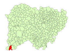
Location in Salamanca
(2018)[2]
37524
El Payo (Payu in Leonese) is a village and municipality in the province of Salamanca, western Spain, part of the autonomous community of Castile-Leon. It is located 135 kilometres (84 mi) from the provincial capital city of Salamanca and has a population of 37 people.
Geography
The municipality covers an area of 62 km2 (24 sq mi). It lies 934 metres (3,064 ft) above sea level and the postal code is 37524.
See also
References
- ^ a b "Municipio:Payo (El)". www.lasalina.es (in Spanish). Retrieved 2017-11-02.
- ^ Municipal Register of Spain 2018. National Statistics Institute.
- v
- t
- e
Municipalities in the province of Salamanca
- Abusejo
- Agallas
- Ahigal de Villarino
- Ahigal de los Aceiteros
- Alaraz
- Alba de Tormes
- Alba de Yeltes
- Alconada
- Aldea del Obispo
- Aldeacipreste
- Aldeadávila de la Ribera
- Aldealengua
- Aldeanueva de Figueroa
- Aldeanueva de la Sierra
- Aldearrodrigo
- Aldearrubia
- Aldeaseca de Alba
- Aldeaseca de la Frontera
- Aldeatejada
- Aldeavieja de Tormes
- Aldehuela de Yeltes
- Aldehuela de la Bóveda
- Almenara de Tormes
- Almendra
- Anaya de Alba
- Arabayona de Mógica
- Arapiles
- Arcediano
- Armenteros
- Añover de Tormes
- Babilafuente
- Barbadillo
- Barbalos
- Barceo
- Barruecopardo
- Bañobárez
- Beleña
- Bermellar
- Berrocal de Huebra
- Berrocal de Salvatierra
- Boada
- Bogajo
- Brincones
- Buenamadre
- Buenavista
- Béjar
- Bóveda del Río Almar
- Cabeza del Caballo
- Cabezabellosa de la Calzada
- Cabrerizos
- Cabrillas
- Calvarrasa de Abajo
- Calvarrasa de Arriba
- Calzada de Don Diego
- Calzada de Valdunciel
- Campillo de Azaba
- Candelario
- Canillas de Abajo
- Cantagallo
- Cantalapiedra
- Cantalpino
- Cantaracillo
- Carbajosa de la Sagrada
- Carpio de Azaba
- Carrascal de Barregas
- Carrascal del Obispo
- Casafranca
- Casillas de Flores
- Castellanos de Moriscos
- Castellanos de Villiquera
- Castillejo de Martín Viejo
- Castraz
- Cepeda
- Cereceda de la Sierra
- Cerezal de Peñahorcada
- Cerralbo
- Cespedosa de Tormes
- Chagarcía Medianero
- Cilleros de la Bastida
- Cipérez
- Ciudad Rodrigo
- Coca de Alba
- Colmenar de Montemayor
- Cordovilla
- Cristóbal de la Sierra
- Dios le Guarde
- Doñinos de Ledesma
- Doñinos de Salamanca
- Éjeme
- El Arco
- El Bodón
- El Cabaco
- El Campo de Peñaranda
- El Cerro
- El Cubo de Don Sancho
- El Manzano
- El Maíllo
- El Milano
- El Payo
- El Pedroso de la Armuña
- El Pino de Tormes
- El Sahugo
- El Tejado
- El Tornadizo
- Encina de San Silvestre
- Encinas de Abajo
- Encinas de Arriba
- Encinasola de los Comendadores
- Endrinal
- Escurial de la Sierra
- Espadaña
- Espeja
- Espino de la Orbada
- Florida de Liébana
- Forfoleda
- Frades de la Sierra
- Fresnedoso
- Fresno Alhándiga
- Fuenteguinaldo
- Fuenteliante
- Fuenterroble de Salvatierra
- Fuentes de Béjar
- Fuentes de Oñoro
- Gajates
- Galindo y Perahuy
- Galinduste
- Galisancho
- Gallegos de Argañán
- Gallegos de Solmirón
- Garcibuey
- Garcihernández
- Garcirrey
- Gejuelo del Barro
- Golpejas
- Gomecello
- Guadramiro
- Guijo de Ávila
- Guijuelo
- Herguijuela de Ciudad Rodrigo
- Herguijuela de la Sierra
- Herguijuela del Campo
- Hinojosa de Duero
- Horcajo Medianero
- Horcajo de Montemayor
- Huerta
- Iruelos
- Ituero de Azaba
- Juzbado
- La Alameda de Gardón
- La Alamedilla
- La Alberca
- La Alberguería de Argañán
- La Atalaya
- La Bastida
- La Bouza
- La Cabeza de Béjar
- La Calzada de Béjar
- La Encina
- La Fregeneda
- La Fuente de San Esteban
- La Hoya
- La Mata de Ledesma
- La Maya
- La Orbada
- La Peña
- La Redonda
- La Rinconada de la Sierra
- La Sagrada
- La Sierpe
- La Tala
- La Vellés
- La Vídola
- La Zarza de Pumareda
- Lagunilla
- Larrodrigo
- Las Casas del Conde
- Las Veguillas
- Ledesma
- Ledrada
- Linares de Riofrío
- Los Santos
- Lumbrales
- Machacón
- Macotera
- Madroñal
- Malpartida
- Mancera de Abajo
- Martiago
- Martinamor
- Martín de Yeltes
- Masueco
- Matilla de los Caños del Río
- Membribe de la Sierra
- Mieza
- Miranda de Azán
- Miranda del Castañar
- Mogarraz
- Molinillo
- Monforte de la Sierra
- Monleras
- Monleón
- Monsagro
- Montejo
- Montemayor del Río
- Monterrubio de Armuña
- Monterrubio de la Sierra
- Morasverdes
- Morille
- Moriscos
- Moronta
- Moríñigo
- Mozárbez
- Narros de Matalayegua
- Nava de Béjar
- Nava de Francia
- Nava de Sotrobal
- Navacarros
- Navales
- Navalmoral de Béjar
- Navamorales
- Navarredonda de la Rinconada
- Navasfrías
- Negrilla de Palencia
- Olmedo de Camaces
- Pajares de la Laguna
- Palacios del Arzobispo
- Palaciosrubios
- Palencia de Negrilla
- Parada de Arriba
- Parada de Rubiales
- Paradinas de San Juan
- Pastores
- Pedraza de Alba
- Pedrosillo de Alba
- Pedrosillo de los Aires
- Pedrosillo el Ralo
- Pelabravo
- Pelarrodríguez
- Pelayos
- Peralejos de Abajo
- Peralejos de Arriba
- Pereña de la Ribera
- Peromingo
- Peñacaballera
- Peñaparda
- Peñaranda de Bracamonte
- Peñarandilla
- Pinedas
- Pitiegua
- Pizarral
- Poveda de las Cintas
- Pozos de Hinojo
- Puebla de Azaba
- Puebla de San Medel
- Puebla de Yeltes
- Puente del Congosto
- Puertas
- Puerto Seguro
- Puerto de Béjar
- Retortillo
- Robleda
- Robliza de Cojos
- Rollán
- Rágama
- Saelices el Chico
- Salamanca
- Saldeana
- Salmoral
- Salvatierra de Tormes
- San Cristóbal de la Cuesta
- San Esteban de la Sierra
- San Felices de los Gallegos
- San Martín del Castañar
- San Miguel de Valero
- San Miguel del Robledo
- San Morales
- San Muñoz
- San Pedro de Rozados
- San Pedro del Valle
- San Pelayo de Guareña
- Sanchotello
- Sanchón de la Ribera
- Sanchón de la Sagrada
- Sancti-Spíritus
- Sando
- Santa Marta de Tormes
- Santa María de Sando
- Santiago de la Puebla
- Santibáñez de Béjar
- Santibáñez de la Sierra
- Santiz
- Sardón de los Frailes
- Saucelle
- Sepulcro-Hilario
- Sequeros
- Serradilla del Arroyo
- Serradilla del Llano
- Sieteiglesias de Tormes
- Sobradillo
- Sorihuela
- Sotoserrano
- Tabera de Abajo
- Tamames
- Tarazona de Guareña
- Tardáguila
- Tejeda y Segoyuela
- Tenebrón
- Terradillos
- Topas
- Tordillos
- Torresmenudas
- Trabanca
- Tremedal de Tormes
- Valdecarros
- Valdefuentes de Sangusín
- Valdehijaderos
- Valdelacasa
- Valdelageve
- Valdelosa
- Valdemierque
- Valderrodrigo
- Valdunciel
- Valero
- Vallejera de Riofrío
- Valsalabroso
- Valverde de Valdelacasa
- Valverdón
- Vecinos
- Vega de Tirados
- Ventosa del Río Almar
- Villaflores
- Villagonzalo de Tormes
- Villalba de los Llanos
- Villamayor
- Villanueva del Conde
- Villar de Argañán
- Villar de Ciervo
- Villar de Gallimazo
- Villar de Peralonso
- Villar de Samaniego
- Villar de la Yegua
- Villares de Yeltes
- Villares de la Reina
- Villarino de los Aires
- Villarmayor
- Villarmuerto
- Villasbuenas
- Villasdardo
- Villaseco de los Gamitos
- Villaseco de los Reyes
- Villasrubias
- Villaverde de Guareña
- Villavieja de Yeltes
- Villoria
- Villoruela
- Vilvestre
- Vitigudino
- Yecla de Yeltes
- Zamarra
- Zamayón
- Zarapicos
- Zorita de la Frontera

 | This article about a location in the province of Salamanca, Spain, is a stub. You can help Wikipedia by expanding it. |
- v
- t
- e


