Fiorentino
Castello of San Marino
Castello in San Marino

Flag
Coat of arms
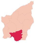
Fiorentino's location in San Marino
 San Marino
List
- Capanne, Crociale, Pianacci
(May 2018)
47897
Fiorentino is one of the nine castelli of San Marino. It has 2,548 inhabitants (May 2018)[1] in an area of 6.57 km2 (2.54 sq mi).
Geography
It borders the San Marino municipalities Chiesanuova, San Marino, Borgo Maggiore, Faetano, and Montegiardino and the Italian municipalities Monte Grimano and Sassofeltrio.
Fiorentino contains three curazie: Capanne, Crociale, and Pianacci.[2][3]
History
Evidence indicates a settlement existed on the site before Roman times.
Sport
The Tre Fiori FC, most successful club in the San Marino league is playing in Fiorentino.
References
- ^ a b http://www.statistica.sm/contents/instance15/files/document/14101672tav_popolazione_.pdf [bare URL PDF]
- ^ Rattini, Maurizio; Venturini, Gian Carlo; Volpinari, Antonio L. (21 March 1997). "Regolamento per la disciplina della campagna elttorale". Elezioni (in Italian). Archived from the original on 5 August 2009. Retrieved 14 February 2020.
- ^ "Fiorentino". San Marino Web (in Italian). Retrieved 9 February 2024.
External links
![]() Media related to Fiorentino at Wikimedia Commons
Media related to Fiorentino at Wikimedia Commons
- v
- t
- e

- Acquaviva
- Borgo Maggiore
- Chiesanuova
- Domagnano
- Faetano
- Fiorentino
- Montegiardino
- San Marino (city)
- Serravalle

43°54′38″N 12°27′20″E / 43.91056°N 12.45556°E / 43.91056; 12.45556
| Authority control databases: Geographic |
|
|---|
 | This Sammarinese location article is a stub. You can help Wikipedia by expanding it. |
- v
- t
- e


