Ghangad
18°32′44.7″N 73°21′34.5″E / 18.545750°N 73.359583°E / 18.545750; 73.359583Type Hill fort Height 3000 Ft. Site information Owner Government of India Open to
the public Yes Condition Ruins Site history Materials Stone Ahmednagar district Akola district Amravati district Aurangabad district Chandrapur district Dhule district Kolhapur district Latur district Mumbai City district Mumbai Suburban district Nagpur district Nanded district Nashik district Osmanabad district Palghar district Pune district Raigad district Ratnagiri district Satara district Sindhudurg district Thane district Jalna district
the public
Ghangad is a fort situated near 30km from Lonavla-Khandala and 100 km from Pune in Maharashtra state, India. It is an important fort in the Pune district. The fort restoration is done by the Shivaji Trail group with the help of local villagers. Restoration work took place in 2011-12.[1] The fort is at least 300 years old.[2]
History
Very little information is available about the history of the fort. It was used for keeping prisoners and for keeping watch on the trade route from Pune to Konkan. Until 1818 the fort was under the Maratha empire. Ot was surrendered to British forces after the fall of Korigad on 17 March 1818.[3]
How to reach
The fort can be reached by road via Tamhini ghat road or via Lonavla. The nearest town is Lonavla which is 30km from the base village of the fort i.e. Ekole. There are good hotels at Lonavla, now tea and snacks are also available in small hotels on the way at Peth Shahapur. The road becomes rugged in the Saltar pass. The trekking path starts from the hillock south of the Ekole village. The route is very safe and wide. There is a dense forest on the trekking route. It takes about half an hour to reach the entrance gate of the fort. The night stay on the fort can be made on the flat ground near the entrance or GarjaiDevi temple on the way to Fort. This fort is approachable in all seasons. The villagers from the Ekole make night stay and food arrangements at reasonable rates.
Places to see
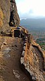
There are two gates on the fort. The main entrance gate has the arch missing. The villagers have placed an iron ladder to climb to the Balekilla of the fort. There is a rock cut water cistern on the way to the second gate. The water is available round the year for drinking purpose. It takes about an hour to visit all places on the fort. There are remains of a few dilapidated buildings on the Balekilla. The top of the balekilla gives a scenic view of the TailBaila, Korigad, Mulshi dam and Sudhagad fort.
Gallery
-
 Main gate of the fort
 -
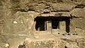 The cave on the fort
 -
 The ladder climb
 -
 Camping site on the fort
 -
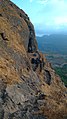 The scarp
 -
 Rockcut water cistern


See also
References
- ^ Swamy, Rohan (28 November 2011). "Road To Recovery". The Indian Express. Retrieved 14 April 2016.
- ^ "Rajasthan to Junnar: Deccan College plans a host of excavationsRajasthan to Junnar:". Times of India. 10 November 2014. Retrieved 14 April 2016.
- ^ https://gazetteers.maharashtra.gov. in/cultural.maharashtra.gov.in/english/gazetteer/Poona%20District/places_k.html#.
- v
- t
- e
Forts in Maharashtra
- Ahmednagar Fort
- Bahadurgad
- Bhairavgad
- Bitangad
- Harishchandragad
- Kaladgad
- Kharda
- Kunjargad
- Madan Fort
- Manjarsumbha fort
- Pabargad
- Patta Fort
- Ratangad
- Amner Fort
- Gawilghur
- Chandrapur Fort
- Ballarpur Fort
- Bhadravati Fort
- Manikgad
- Aavandhagad
- Achala Fort
- Ahivant Fort
- Alang
- Anjaneri
- Ankai Fort
- Bahulagad
- Bhaskargad
- Chandwad
- Chauler Fort
- Dermal
- Dhodap
- Hargad
- Harihar fort
- Hatgad
- Indrai
- Kanchangad
- Kanhergad
- Kavnai fort
- Kulang
- Madangad
- Malegaon
- Mangi-Tungi
- Moragad
- Mulher
- Nhavigad
- Rajdher fort
- Ramsej
- Salher
- Salota
- Saptashrungi
- Tankai fort
- Tringalwadi
- Waghera
- Anghaai Fort
- Bhorgiri Fort
- Chawand
- Dhakoba
- Ghangad
- Hadsar Fort
- Induri Fort
- Jivdhan
- Kailasgad
- Kawla
- Korigad/Koraigad
- Lohagad
- Malhargad
- Manaranjan
- Mangalgad
- Morgiri Fort
- Narayangad
- Nimgiri
- Purandar
- Rajgad
- Rajmachi
- Rayri Fort
- Rohida
- Sangram Durg
- Sindola Fort
- Shaniwar Wada
- Shivneri
- Shrivardhan
- Sinhagad
- Tikona
- Torna
- Tung
- Vajragad Fort
- Visapur
- Agarkot
- Avchitgad
- Bhimashankar Fort
- Birwadi
- Chambhargad
- Chandragad
- Dhak Bahiri
- Dronagiri
- Gadad Bahiri
- Ghangad
- Ghosalgad
- Irshalgad
- Karnala
- Khaderi
- Khanderi
- Kondhawi Fort
- Korlai
- Kothaligad Peb fort
- Kulaba
- Kurdugad
- Lingana
- Maangad
- Madgad
- Malanggad
- Mangalgad (Kangori)
- Manikgad
- Mirgad
- Mrugagad
- Murud-Janjira
- Padargad
- Padmadurg/ Kasa Fort
- Prabalgad
- Raigad
- Ratnagad
- Revdanda
- Sagargad
- Samrajgad
- Sankshi Fort
- Sarasgad
- Sarjekot
- Songad
- Songiri Fort
- Sudhagad
- Surgad
- Talagad
- Underi
- Vikatgad Peb fort
- Aambolgad
- Anjanwel
- Bankot
- Gowalkot
- Jaigad
- Kanakdurg
- Mahipatgad
- Mandangad
- Prachitgad
- Prunagad
- Rasalgad
- Ratnagiri (Ratnadurg)
- Sumargad
- Suvarnadurg
- Yashwantgad
- Ajinkyatara
- Bhairavgad
- Bhushangad
- Chandan-Vandan
- Dategad
- Gunavantgad
- Jangali Jayagad
- Kalyangad
- Kamalgad
- Kenjalgad
- Mahimangad
- Pandavgad
- Prachitgad
- Pratapgad
- Sajjangad
- Santoshgad
- Vairatgad
- Vardhangad
- Varugad
- Vasantgad
- Vasota
- Aasavgad
- Bharatgad
- Rajkot Fort
- Sanrjekot
- Sindhudurg
- Vijaydurg
- Aasawa
- Arnala
- Asherigad
- Ballalgad
- Balwantgad
- Belapur Fort
- Bhairavgad
- Bhandargad
- Bhavanigad
- Bhupatgad
- Chanderigad
- Dahanugad
- Daulatmandal
- Dharavi
- Durgadi Fort
- Gambhirgad
- Ghodbunder Fort
- Gorakhgad
- Gotara
- Jivdhaanigad
- Kamandurg
- Kelwegad
- Kohojgad
- Mahuli
- Malang gad
- Palasgad
- Pankot
- Tahuli
- Shirgav Fort
- Jalna Fort(Mastgarh)
- Rohilagarh
- Jafrabad Qila
| |
|---|---|
| Chhatrapatis | |
| Peshwas | |
| Amatya & Pratinidhi | |
| Women | |
| Maratha Confederacy | |
| Battles |
|
| Wars | |
| Adversaries | |
| Forts | |
| Coins | |


