Gumtow
Municipality in Brandenburg, Germany
Location of Gumtow within Prignitz district

(2016–24) Stefan Freimark[1]
(2022-12-31)[2]
16866
Gumtow is a municipality in the Prignitz district, in Brandenburg, Germany.
Demography
-
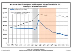 Development of population since 1875 within the current Boundaries (Blue Line: Population; Dotted Line: Comparison to Population development in Brandenburg state; Grey Background: Time of Nazi Germany; Red Background: Time of communist East Germany)
 -
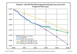 Recent Population Development and Projections (Population Development before Census 2011 (blue line); Recent Population Development according to the Census in Germany in 2011 (blue bordered line); Official projections for 2005-2030 (yellow line); for 2017-2030 (scarlet line); for 2020-2030 (green line)


|
|
|
References
- ^ Landkreis Prignitz Wahl der Bürgermeisterin / des Bürgermeisters, accessed 2 July 2021.
- ^ "Bevölkerungsentwicklung und Bevölkerungsstandim Land Brandenburg Dezember 2022" (PDF). Amt für Statistik Berlin-Brandenburg (in German). June 2023.
- ^ Detailed data sources are to be found in the Wikimedia Commons.Population Projection Brandenburg at Wikimedia Commons
- v
- t
- e
Towns and municipalities in Prignitz
- Bad Wilsnack
- Berge
- Breese
- Cumlosen
- Gerdshagen
- Groß Pankow (Prignitz)
- Gülitz-Reetz
- Gumtow
- Halenbeck-Rohlsdorf
- Karstädt
- Kümmernitztal
- Lanz
- Legde/Quitzöbel
- Lenzen (Elbe)
- Lenzerwische
- Marienfließ
- Meyenburg
- Perleberg
- Pirow
- Plattenburg
- Pritzwalk
- Putlitz
- Rühstädt
- Triglitz
- Weisen
- Wittenberge

Authority control databases | |
|---|---|
| International |
|
| National |
|
| Geographic |
|
 | This Brandenburg location article is a stub. You can help Wikipedia by expanding it. |
- v
- t
- e


