Hrútafjörður
You can help expand this article with text translated from the corresponding article in Icelandic. (January 2022) Click [show] for important translation instructions.
- Machine translation, like DeepL or Google Translate, is a useful starting point for translations, but translators must revise errors as necessary and confirm that the translation is accurate, rather than simply copy-pasting machine-translated text into the English Wikipedia.
- Do not translate text that appears unreliable or low-quality. If possible, verify the text with references provided in the foreign-language article.
- You must provide copyright attribution in the edit summary accompanying your translation by providing an interlanguage link to the source of your translation. A model attribution edit summary is
Content in this edit is translated from the existing Icelandic Wikipedia article at [[:is:Hrútafjörður]]; see its history for attribution. - You may also add the template
{{Translated|is|Hrútafjörður}}to the talk page. - For more guidance, see Wikipedia:Translation.

Hrútafjörður (Icelandic pronunciation: [ˈr̥uːtaˌfjœrðʏr̥] ⓘ) is a fjord in the north-west of Iceland. It is around 36 km long and lies to the south of Húnaflói bay.
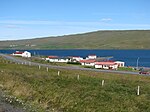
There are a few farmsteads on the shores of the fjord, and one (tiny) village, Borðeyri, with 16 inhabitants.
The junction and farmstead of Brú is at its southern tip; it serves as a local agricultural service station.
"Hrúta" is plural possessive of "Hrútur" which means the male sheep.
-
 Borðeyri
 -
 Southern end of Hrútafjörður
 -
 Hrútafjörður


See also
 Media related to Hrútafjörður at Wikimedia Commons
| Authority control databases |
|
|---|
65°21′N 21°09′W / 65.350°N 21.150°W / 65.350; -21.150
- v
- t
- e


