Isabella, Minnesota
Unincorporated community in Minnesota, United States
Unincorporated community in Minnesota, United States
47°37′02″N 91°21′18″W / 47.61722°N 91.35500°W / 47.61722; -91.3550055607
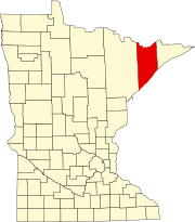
Isabella is a remote[2] unincorporated community in Stony River Township, Lake County, Minnesota, United States.
The community is located 27 miles (43 km) north of Silver Bay, and 40 miles (64 km) southeast of Ely; at the intersection of Minnesota State Highway 1 and Forest Road 172 (Wanless Road).
Isabella is located within the Superior National Forest.
Climate
According to the Köppen Climate Classification system, Isabella has a warm-summer humid continental climate, abbreviated "Dfb" on climate maps. The hottest temperature recorded in Isabella was 91 °F (32.8 °C) on July 3–4, 2020, while the coldest temperature recorded was −42 °F (−41.1 °C) on January 27, 2019 and January 31, 2019.[3]
| Climate data for Isabella, Minnesota, 1991–2020 normals, extremes 2009–2020 | |||||||||||||
|---|---|---|---|---|---|---|---|---|---|---|---|---|---|
| Month | Jan | Feb | Mar | Apr | May | Jun | Jul | Aug | Sep | Oct | Nov | Dec | Year |
| Record high °F (°C) | 41 (5) | 56 (13) | 72 (22) | 75 (24) | 88 (31) | 88 (31) | 91 (33) | 88 (31) | 84 (29) | 79 (26) | 67 (19) | 46 (8) | 91 (33) |
| Mean daily maximum °F (°C) | 16.1 (−8.8) | 21.7 (−5.7) | 34.3 (1.3) | 47.8 (8.8) | 62.7 (17.1) | 71.4 (21.9) | 76.2 (24.6) | 74.8 (23.8) | 65.0 (18.3) | 50.2 (10.1) | 34.0 (1.1) | 21.9 (−5.6) | 48.0 (8.9) |
| Daily mean °F (°C) | 5.5 (−14.7) | 9.2 (−12.7) | 22.7 (−5.2) | 36.5 (2.5) | 50.6 (10.3) | 59.9 (15.5) | 64.5 (18.1) | 62.8 (17.1) | 54.2 (12.3) | 41.0 (5.0) | 26.4 (−3.1) | 13.0 (−10.6) | 37.2 (2.9) |
| Mean daily minimum °F (°C) | −5.2 (−20.7) | −3.3 (−19.6) | 11.0 (−11.7) | 25.1 (−3.8) | 38.5 (3.6) | 48.4 (9.1) | 52.8 (11.6) | 50.7 (10.4) | 43.4 (6.3) | 31.8 (−0.1) | 18.7 (−7.4) | 4.1 (−15.5) | 26.3 (−3.1) |
| Record low °F (°C) | −42 (−41) | −40 (−40) | −35 (−37) | −10 (−23) | 17 (−8) | 27 (−3) | 28 (−2) | 25 (−4) | 18 (−8) | 12 (−11) | −21 (−29) | −42 (−41) | −42 (−41) |
| Average precipitation inches (mm) | 0.94 (24) | 0.87 (22) | 1.54 (39) | 2.08 (53) | 3.17 (81) | 4.26 (108) | 4.06 (103) | 3.27 (83) | 3.54 (90) | 3.10 (79) | 1.91 (49) | 1.21 (31) | 29.95 (762) |
| Source 1: NOAA[4] | |||||||||||||
| Source 2: National Weather Service[3] | |||||||||||||
See also
References
- ^ "Isabella, Minnesota". Geographic Names Information System. United States Geological Survey, United States Department of the Interior.
- ^ "Guide to Isabella Minnesota". www.lakesnwoods.com. Retrieved February 2, 2022.
- ^ a b "NOAA Online Weather Data – NWS Duluth". National Weather Service. Retrieved July 7, 2023.
- ^ "U.S. Climate Normals Quick Access – Station: Isabella 14W, MN". National Oceanic and Atmospheric Administration. Retrieved July 7, 2023.
- v
- t
- e
Municipalities and communities of Lake County, Minnesota, United States
County seat: Two Harbors
communities
territories
- Minnesota portal
- United States portal
Portal:
 United States
 | This article about a location in Lake County, Minnesota is a stub. You can help Wikipedia by expanding it. |
- v
- t
- e


