Jhunjhunu district
District of Rajasthan in India
- Jhunjhunu
- Chirawa
- Buhana
- Nawalgarh
- Malsisar
- Surajgarh
- Mandawa
- Gudha Gorji
(2011)
Jhunjhunu district is a district of the Indian state of Rajasthan in northern India. The city of Jhunjhunu is the district headquarters. Jhunjhunu is an old and historical town having its own district headquarters. It is said that it was ruled over by Chouhan dynasty in the Vikram era 1045. The district is famous for the frescos on its grand Havelis. It is also famous for providing considerable representation to Indian defense forces. Jhunjhunu district was named in the memory of a Jat named “Jhunjha” or “Jujhar Singh Nehra”. The district has a population of 2,139,658 (2011 census), an area of 5926 km², and a population density of 361 persons per km. The district falls within Shekhawati region, and is bounded on the North-East and East by Haryana state, on the South-East, South & South-West by Sikar District & on the North-West and North by Churu District.[3]
Demographics
| Year | Pop. | ±% p.a. |
|---|---|---|
| 1901 | 341,572 | — |
| 1911 | 369,081 | +0.78% |
| 1921 | 353,140 | −0.44% |
| 1931 | 405,519 | +1.39% |
| 1941 | 491,003 | +1.93% |
| 1951 | 588,736 | +1.83% |
| 1961 | 719,650 | +2.03% |
| 1971 | 929,230 | +2.59% |
| 1981 | 1,211,583 | +2.69% |
| 1991 | 1,582,421 | +2.71% |
| 2001 | 1,913,689 | +1.92% |
| 2011 | 2,137,045 | +1.11% |
| source:[4] | ||
According to the 2011 census Jhunjhunu district has a population of 2,139,658,[5] roughly equal to the nation of Namibia[6] or the US state of New Mexico.[7] This gives it a ranking of 214th in India (out of a total of 640).[5] The district has a population density of 361 inhabitants per square kilometre (930/sq mi).[5] Its population growth rate over the decade 2001-2011 was 11.81%.[5] Jhunjhunu has a sex ratio of 950 females for every 1000 males,[5] It also has a literacy rate of 74.72% which is considered excellent. 22.89% of the population live in urban areas. Scheduled Castes and Scheduled Tribes make up 16.88% and 1.95% of the population respectively.[5]
Languages
Shekhawati a dialect of Rajasthani, and Hindi are mainly spoken languages. The language blends into Haryanvi along the Haryana border.
Places of interest
There are various places of interests in and around Jhunjhunu.
- Khetri Mahal
- Alsisar Mahal in Alsisar
- Tibrewala and Modi Haveli
- Bissau Fort, Bissau
- Surajgarh Fort, Surajgarh
- Bissau Mahal, Bissau
- Shyamgarh Fort in Jhunjhunu
- Bishangarh Fort in Tamkor
- Mandawa Fort (Castle Mandawa) in Mandawa
- Sculpture of Jujhar Singh
- Havelis in Nawalgarh
- Havelis and forts of Mukundgarh
- Sarju Sagar Dam
- Dhosi Hill
Museums
- Birla Science Museum, Pilani
- Ajit-Vivekananda Museum, Khetri
- Science park Nawalgarh
Fairs
- Gangaur Mela of Baragaon
- Gangaur Mela of Bhagera
- Ramdev ji Mela, Nawalgarh
Film location
The Mandawa area of Jhunjhunu district has been used as a film location for several Bollywood films, including the dance sequences of "Cutie Pie" in the movie Ae Dil Hai Mushkil, and the portrayal of Mandawa as Lucknow in the same film, and as Pakistan in Kabir Khan’s Bajrangi Bhaijaan.
Other notable films shot in the district include Half Girlfriend, Mirziya, PK, Jab We Met, Paheli, Shudh Desi Romance, Dolly Ki Doli, Manorama Six Feet Under and Kachche Dhaage.[9]
Education
Universities and colleges
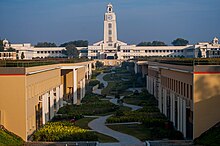
Universities in the district include Birla Institute of Technology & Science, Pilani (BITS Pilani) and Central Electronics Engineering Research Institute (CEERI), in Pilani, Jhunjhunu.
Plans are underway for the establishment of a new Sports University in the Jakhron Ka Bas, Deorasar,[10] supported by the Government of Rajasthan.
Schools
- Birla Public School
- Jhunjhunu Academy, Jhunjhunu
- Birla School Pilani
- Birla Balika Vidyapeeth, Pilani
Notable people
- Padma Shri Shish Ram Ola, Minister of Labour and Employment (17 June 2013 – 15 December 2013), Member of 11th Lok Sabha,12th Lok Sabha,13th Lok Sabha,14th Lok Sabha & 15th Lok Sabha
- Jagdeep Dhankhar, 14th Vice President of India
- Param Vir Piru Singh, an Indian Army non-commissioned officer, awarded the Param Vir Chakra (PVC), India's highest military decoration[11]
- Acharya Shri Mahapragya (The tenth head of the Svetambar Terapanth order of Jainism)
- Ajit Singh of Khetri, Friend of Swami Vivekananda
- G.D. Birla, industrialist
- Ajay Piramal, industrialist
- Karmveer Choudhary, Bollywood and television actor
- Kirti Kulhari, Bollywood actress
- Mehdi Hassan, Pakistani gazal and playback singer
- Kulwant Khejroliya , Domestic cricketer. Only player from Jhunjhunu to play in Indian Premier League
- Salim Diwan, Bollywood actor
- Chhatrapal Singh, recipient of the Sena Medal[12][13][14]
See also
References
- ^ "Parliamentary Constituencies of Rajasthan" (PDF). 2012. Archived from the original (PDF) on 16 June 2013. Retrieved 23 February 2012.
- ^ "Assembly Constituencies of Jhunjhunu district" (PDF). gisserver1.nic.in. 2012. Archived from the original (PDF) on 3 June 2013. Retrieved 23 February 2012.
- ^ "History | District & Sessions Court Jhunjhunu | India". Retrieved 3 May 2024.
- ^ "Decadal Variation In Population Since 1901". Archived from the original on 8 August 2019. Retrieved 9 August 2019.
- ^ a b c d e f "District Census Handbook 2011: Jhunjhunu" (PDF). Census of India. Registrar General and Census Commissioner of India.
- ^ US Directorate of Intelligence. "Country Comparison:Population". Archived from the original on 27 September 2011. Retrieved 1 October 2011.
Namibia 2,147,585
- ^ "2010 Resident Population Data". U. S. Census Bureau. Archived from the original on 19 October 2013. Retrieved 30 September 2011.
New Mexico - 2,059,179
- ^ "Table C-01 Population By Religion - Rajasthan". census.gov.in. Registrar General and Census Commissioner of India.
- ^ TLJ, Team (24 January 2017). "Mandawa, Bollywood's Favourite Shooting Destination In Rajasthan". thelifestylejournalist.com. Retrieved 5 May 2024.
- ^ "Vice Chancellors of State Universities". rajbhawan.rajasthan.gov.in. Retrieved 5 May 2024.
- ^ "Param vir Chakra winners since 1950 | India News - Times of India". The Times of India.
- ^ "Jhunjhunu army jawan, Chhatrapal Singh, martyred in Jammu and Kashmir". The PinkCity Post. 6 April 2020. Retrieved 17 October 2021.
- ^ ANI (7 April 2020). "Mortal remains of paratrooper Chhtrapal Singh brought to Jhunjhunu". Business Standard India. Retrieved 17 October 2021.
- ^ Saini, Vishwanath (6 April 2020). "छत्रपाल सिंह : 1997 में जन्म, 2015 में आर्मी ज्वाइन, 2018 में बने कमांडो, 2020 में LOC पर शहीद". hindi.oneindia.com (in Hindi). Retrieved 17 October 2021.
External links
Wikimedia Commons has media related to Jhunjhunu district.
- Official website
Places adjacent to Jhunjhunu district | ||||||||||||||||
|---|---|---|---|---|---|---|---|---|---|---|---|---|---|---|---|---|
| ||||||||||||||||


- v
- t
- e
Populated places in Jhunjhunu district
towns
settlements
- Babai rajasthan
- Badangarh
- Bagholi
- Balonda
- Bhaisawata Kalan
- Bhojgarh
- Chhau
- Devroad
- Dhani Bhaloth
- Dhani Kumharan
- Dhanuri
- Dhosi
- Dobra
- Garodia Ki Dhani
- Gorir
- Gudhagorji
- Hanumanpur
- Jakhal
- Jalimpura
- Jhajhar
- Kalipahari
- Kant Alsisar
- Kanwarpura
- Kari
- Ked
- Khudania
- Kishorpura
- Kodesar
- Kuharu
- Kumharon Ka Bass
- Mahansar
- Mahapalwas
- Manaksas
- Mandela
- Narhar
- Navora Ki Dhani
- Netrampura
- Nua
- Pacheri
- Papurana
- Parasrampuria
- Patusari
- Posana
- Pujari Ki Dhani
- Signore
- Sonasar
- Sotwara
- Sultana
- Tain
- Tamkor
- Tatija
- Tetara
- Togra Sawroop Singh
| ||
|---|---|---|
| Outline |  | |
| Governance | ||
| Divisions and districts | ||
| Major cities | ||
| Related templates |
| |

Authority control databases | |
|---|---|
| International |
|
| National |
|


