Küstriner Vorland
Municipality in Brandenburg, Germany

Coat of arms
Location of Küstriner Vorland within Märkisch-Oderland district

(2019–24) Werner Finger[1]
(2022-12-31)[2]
15328
Küstriner Vorland (literally "Küstrin's foreland") is a municipality in the district Märkisch-Oderland, in Brandenburg, Germany at the border with Poland.
History
It was established on January 1, 1998, by the merger of Küstrin-Kietz with the villages of Gorgast and Manschnow. Küstriner Vorland is part of the Amt ("collective municipality") Golzow.
The settlement of Küstrin-Kietz formed the western part of Küstrin which is now Polish Kostrzyn nad Odrą, until it was cut off by the implementation of the Oder-Neisse line in 1945. The town's quarters west of the Oder River then belonged to East Germany and were renamed Kietz in 1954. In a 1991 vote the inhabitants chose to readopt the historic denotation.
The incorporated village of Gorgast, once a commandry of the Order of Saint John, features a historic fort finished in 1889 in addition to the Küstrin fortification system and a park laid out according to plans by Peter Joseph Lenné.
Politics
Seats in the municipal assembly (Gemeinderat) as of 2008 elections:
- IG Küstriner Vorland (Free Voters): 9
- The Left: 3
- Pro Zukunft (Free Voters): 1
- Evangelical parish: 1
- Independent: 2
Transport
The border crossing at Küstrin-Kietz is the eastern terminus of the Bundesstraße 1 federal highway from Aachen via Berlin. It is continued by the Polish national road No. 22 to Gorzów Wielkopolski and Elbląg.
Küstrin-Kietz as well as Gorgast also have access to local trains running on the former Prussian Eastern Railway from Berlin-Lichtenberg to Küstrin (Kostrzyn nad Odrą).
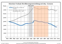
Demography
|
|
References
- ^ Landkreis Märkisch-Oderland Wahl der Bürgermeisterin / des Bürgermeisters, accessed 1 July 2021.
- ^ "Bevölkerungsentwicklung und Bevölkerungsstandim Land Brandenburg Dezember 2022" (PDF). Amt für Statistik Berlin-Brandenburg (in German). June 2023.
- ^ Detailed data sources are to be found in the Wikimedia Commons.Population Projection Brandenburg at Wikimedia Commons
External links
![]() Media related to Küstriner Vorland at Wikimedia Commons
Media related to Küstriner Vorland at Wikimedia Commons
- v
- t
- e
Towns and municipalities in Märkisch-Oderland
- Alt Tucheband
- Altlandsberg
- Bad Freienwalde
- Beiersdorf-Freudenberg
- Bleyen-Genschmar
- Bliesdorf
- Buckow
- Falkenberg
- Falkenhagen
- Fichtenhöhe
- Fredersdorf-Vogelsdorf
- Garzau-Garzin
- Golzow
- Gusow-Platkow
- Heckelberg-Brunow
- Höhenland
- Hoppegarten
- Küstriner Vorland
- Lebus
- Letschin
- Lietzen
- Lindendorf
- Märkische Höhe
- Müncheberg
- Neuenhagen bei Berlin
- Neuhardenberg
- Neulewin
- Neutrebbin
- Oberbarnim
- Oderaue
- Petershagen-Eggersdorf
- Podelzig
- Prötzel
- Rehfelde
- Reichenow-Möglin
- Reitwein
- Rüdersdorf
- Seelow
- Strausberg
- Treplin
- Vierlinden
- Waldsieversdorf
- Wriezen
- Zechin
- Zeschdorf

Authority control databases | |
|---|---|
| International |
|
| National |
|


