Kansas statistical areas
Kansas statistical areas
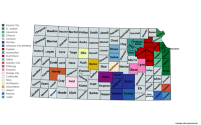
The U.S. State of Kansas currently has 23 statistical areas that have been delineated by the Office of Management and Budget (OMB). On March 6, 2020, the OMB delineated three combined statistical areas, seven metropolitan statistical areas, and 13 micropolitan statistical areas in Kansas.[1]
Background
The Office of Management and Budget (OMB) has designated more than 1,000 statistical areas for the United States and Puerto Rico.[2] These statistical areas are important geographic delineations of population clusters used by the OMB, the United States Census Bureau, planning organizations, and federal, state, and local government entities.
The OMB defines a core-based statistical area (commonly referred to as a CBSA) as the county or counties (or county-equivalents) surrounding at least one densely-settled core of at least 10,000 population,[2] "plus adjacent counties having a high degree of social and economic integration with the core as measured through commuting ties with the counties containing the core".[2] The OMB further divides core-based statistical areas based on population into metropolitan statistical areas (MSAs) for those with at least 50,000 and micropolitan statistical areas (μSAs) for those with 10,000 to 49,999 people.[2]
The OMB defines a combined statistical area (CSA) as two or more adjacent core-based statistical areas where the employment interchange rate (% commuting from A to B plus % commuting from B to A) is at least 15%.[2] The primary statistical areas (PSAs) include all combined statistical areas and any core-based statistical area that is not a constituent of a combined statistical area.
Table
See also
 Geography portal
 United States portal
 Kansas portal


Notes
References
- ^ a b c d Revised Delineations of Metropolitan Statistical Areas, Micropolitan Statistical Areas, and Combined Statistical Areas, and Guidance on Uses of the Delineations of These Areas (July 21, 2023). "0MB BULLETIN NO. 23-01" (PDF). Office of Management and Budget. Retrieved March 12, 2024.
{{cite web}}: CS1 maint: multiple names: authors list (link) - ^ a b c d e "2020 Standards for Delineating Core Based Statistical Areas". Office of Management and Budget. July 16, 2021. Retrieved December 13, 2021.
- ^ a b c "County Population Totals and Components of Change: 2020-2023". United States Census Bureau, Population Division. March 6, 2024. Retrieved March 15, 2024.
External links
Kansas at Wikipedia's sister projects
 Media from Commons
 News from Wikinews
 Quotations from Wikiquote
 Travel information from Wikivoyage
- Office of Management and Budget
- United States Census Bureau
- v
- t
- e
Topeka (capital)
- Index
- Abortion
- Cannabis
- Culture
- Climate change
- Crime
- Demographics
- Economy
- Education
- Geography
- Gun laws
- History
- Homelessness
- Landmarks
- LGBT rights
- People
- Politics
- Symbols
- Tourist attractions
- Constitutions
- Capitals
- Capitols
- Delegations
- Governors
- Cherokee Strip
- Cross Timbers
- Dissected Till Plains
- East Central
- Four State Area
- Flint Hills
- High Plains
- KC metro area
- North Central
- Osage Plains
- Ozarks
- Red Hills
- Santa Fe Trail Region
- Smoky Hills
- Southeast
- Allen
- Anderson
- Atchison
- Barber
- Barton
- Bourbon
- Brown
- Butler
- Chase
- Chautauqua
- Cherokee
- Cheyenne
- Clark
- Clay
- Cloud
- Coffey
- Comanche
- Cowley
- Crawford
- Decatur
- Dickinson
- Doniphan
- Douglas
- Edwards
- Elk
- Ellis
- Ellsworth
- Finney
- Ford
- Franklin
- Geary
- Gove
- Graham
- Grant
- Gray
- Greeley
- Greenwood
- Hamilton
- Harper
- Harvey
- Haskell
- Hodgeman
- Jackson
- Jefferson
- Jewell
- Johnson
- Kearny
- Kingman
- Kiowa
- Labette
- Lane
- Leavenworth
- Lincoln
- Linn
- Logan
- Lyon
- Marion
- Marshall
- McPherson
- Meade
- Miami
- Mitchell
- Montgomery
- Morris
- Morton
- Nemaha
- Neosho
- Ness
- Norton
- Osage
- Osborne
- Ottawa
- Pawnee
- Phillips
- Pottawatomie
- Pratt
- Rawlins
- Reno
- Republic
- Rice
- Riley
- Rooks
- Rush
- Russell
- Saline
- Scott
- Sedgwick
- Seward
- Shawnee
- Sheridan
- Sherman
- Smith
- Stafford
- Stanton
- Stevens
- Sumner
- Thomas
- Trego
- Wabaunsee
- Wallace
- Washington
- Wichita
- Wilson
- Woodson
- Wyandotte
 Kansas portal
38°29′37″N 98°22′49″W / 38.4937°N 98.3804°W / 38.4937; -98.3804 (State of Kansas)


