Kleve (district)
District in North Rhine-Westphalia, Germany

Flag
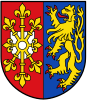
Coat of arms

(31 December 2022)[1]
Kleve (Cleves in English use) or Kreis Kleve is a Kreis (local-government district) in the Lower Rhine region of northwestern North Rhine-Westphalia, Germany. Neighbouring districts are Borken, Wesel, and Viersen in Germany, and the Dutch provinces of Limburg and Gelderland.
History
The district in its current borders was created in 1975 when the former district of Kleve and Geldern was merged with the Rees District towns of Emmerich and Rees and the Moers District municipality of Rheurdt.
The two precursor districts had been created in 1816 when the whole of the Rhineland became a province of Prussia. Territorially they corresponded roughly to the historic Duchies of Cleves and Guelders.
Geography
The district is located in the lower valley of the Rhine, in the region where that river flows into the Netherlands.
Coat of arms
The coat of arms, which was granted in 1983, combines the shields of the two constituent duchies.
The dexter side depicts the emblem of the dukes of Cleves: On a red (gules) field a white (argent) escutcheon (shield shape) with an eightfold fleur-de-lys (escarbuncle/metal shield reinforcement). The sinister side shows a golden (or) lion (in rampant position) on a blue (azure) field (background): the emblem of the dukes of Geldern.
Towns and municipalities

| Towns (Städte) | Municipalities (Gemeinden) |
|---|---|
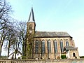
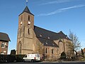
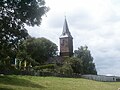
Gallery of churches in Kleve
-
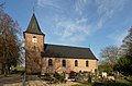 Bimmen, St. Martin
 -
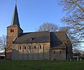
 Düffelward, St. Maurice
 -
 Griethausen, St. Martin
 -
 Keeken, St. Mariae Himmelfahrt
 -
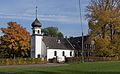 Keeken, Reformed church
 -
 Kellen, St. Willibrord
 -
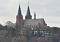 Kleve, St. Mariae Himmelfahrt
 -
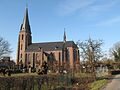
 Materborn, St. Anna
 -
 Rindern, St. Willibrord
 -
 Schenkenschanz, Reformed church


References
- ^ "Bevölkerung der Gemeinden Nordrhein-Westfalens am 31. Dezember 2022 – Fortschreibung des Bevölkerungsstandes auf Basis des Zensus vom 9. Mai 2011" (in German). Landesbetrieb Information und Technik NRW. Retrieved 20 June 2023.
External links
 Media related to Kreis Kleve at Wikimedia Commons
- Official website (in German)
- v
- t
- e
Urban and rural districts in the state of North Rhine-Westphalia in Germany

- Aachen
- Borken
- Coesfeld
- Düren
- Ennepe-Ruhr-Kreis
- Euskirchen
- Gütersloh
- Heinsberg
- Herford
- Hochsauerlandkreis
- Höxter
- Kleve (Cleves)
- Lippe
- Märkischer Kreis
- Mettmann
- Minden-Lübbecke
- Oberbergischer Kreis
- Olpe
- Paderborn
- Recklinghausen
- Rheinisch-Bergischer Kreis
- Rhein-Erft-Kreis
- Rhein-Kreis Neuss
- Rhein-Sieg-Kreis
- Siegen-Wittgenstein
- Soest
- Steinfurt
- Unna
- Viersen
- Warendorf
- Wesel
Authority control databases | |
|---|---|
| International |
|
| National |
|


