Kolbingen
You can help expand this article with text translated from the corresponding article in German. (February 2009) Click [show] for important translation instructions.
- View a machine-translated version of the German article.
- Machine translation, like DeepL or Google Translate, is a useful starting point for translations, but translators must revise errors as necessary and confirm that the translation is accurate, rather than simply copy-pasting machine-translated text into the English Wikipedia.
- Do not translate text that appears unreliable or low-quality. If possible, verify the text with references provided in the foreign-language article.
- You must provide copyright attribution in the edit summary accompanying your translation by providing an interlanguage link to the source of your translation. A model attribution edit summary is
Content in this edit is translated from the existing German Wikipedia article at [[:de:Kolbingen]]; see its history for attribution. - You may also add the template
{{Translated|de|Kolbingen}}to the talk page. - For more guidance, see Wikipedia:Translation.
Municipality in Baden-Württemberg, Germany

Coat of arms
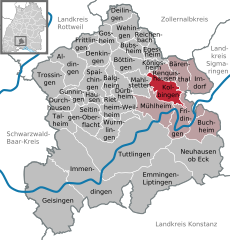
Location of Kolbingen within Tuttlingen district
(2021–29) Christian Valentin Abert[1]
(2022-12-31)[2]
78600
Kolbingen is a municipality in the district of Tuttlingen in Baden-Württemberg in Germany. It is situated about 15 km northeast of Tuttlingen and 7 km from Mühlheim an der Donau.
Demographics
Population development:[3]
|
Farming
To help people to help themselves Württemberg planted alleys of fruit-trees (Dienstbarkeit on private ground near streets). The tree farms from William I of Württemberg, also the Brüdergemeinde delivered for free.[4] The Kolbinger Goldbirne is a local tree.
References
- ^ Aktuelle Wahlergebnisse, Staatsanzeiger, accessed 15 September 2021.
- ^ "Bevölkerung nach Nationalität und Geschlecht am 31. Dezember 2022" [Population by nationality and sex as of December 31, 2022] (CSV) (in German). Statistisches Landesamt Baden-Württemberg. June 2023.
- ^ "Kolbingen (Tuttlingen, Baden-Württemberg, Deutschland) - Einwohnerzahlen, Grafiken, Karte, Lage, Wetter und Web-Informationen". www.citypopulation.de. Retrieved 2023-05-23.
- ^ Apfelgeschichte Archived 2020-09-29 at the Wayback Machine auf Apfelgut Sulz
External links
- Official Web site for the city of Kolbingen (in German)
- v
- t
- e
Towns and municipalities in Tuttlingen (district)
- Aldingen
- Balgheim
- Bärenthal
- Böttingen
- Bubsheim
- Buchheim
- Deilingen
- Denkingen
- Dürbheim
- Durchhausen
- Egesheim
- Emmingen-Liptingen
- Fridingen
- Frittlingen
- Geisingen
- Gosheim
- Gunningen
- Hausen ob Verena
- Immendingen
- Irndorf
- Kolbingen
- Königsheim
- Mahlstetten
- Mühlheim
- Neuhausen ob Eck
- Reichenbach
- Renquishausen
- Rietheim-Weilheim
- Seitingen-Oberflacht
- Spaichingen
- Talheim
- Trossingen
- Tuttlingen
- Wehingen
- Wurmlingen

Authority control databases | |
|---|---|
| International |
|
| National |
|
 | This Tuttlingen district location article is a stub. You can help Wikipedia by expanding it. |
- v
- t
- e


