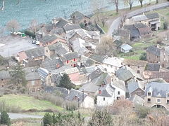
Le Truel
Commune in Occitanie, France
You can help expand this article with text translated from the corresponding article in French. (December 2008) Click [show] for important translation instructions.
- View a machine-translated version of the French article.
- Machine translation, like DeepL or Google Translate, is a useful starting point for translations, but translators must revise errors as necessary and confirm that the translation is accurate, rather than simply copy-pasting machine-translated text into the English Wikipedia.
- Do not translate text that appears unreliable or low-quality. If possible, verify the text with references provided in the foreign-language article.
- You must provide copyright attribution in the edit summary accompanying your translation by providing an interlanguage link to the source of your translation. A model attribution edit summary is
Content in this edit is translated from the existing French Wikipedia article at [[:fr:Le Truel]]; see its history for attribution. - You may also add the template
{{Translated|fr|Le Truel}}to the talk page. - For more guidance, see Wikipedia:Translation.
Commune in Occitania, France

Coat of arms
Location of Le Truel

(2020–2026) Jean-Pierre Alibert[1]
1
(2021)[2]
12284 /12430
(avg. 260 m or 850 ft)
Le Truel (French pronunciation: [lə tʁyɛl]; Occitan: Lo Truèlh) is a commune in the Aveyron department in southern France. The village was in the ancient province of Rouergue where they spoke in the rouergat patois of Occitan.
Geography
The commune is on the southern edge of the Massif Central. The hamlets to the north have commanding views of the Cevennes and the Millau Viaduct, which is 20 miles (32 km) to the west. The commune is approached along the D200 which connects it to the A75 autoroute. The D200 runs alongside the Tarn which has been dammed and provides the power for two hydro-electric generating plants, Jourdanie and Le Pouget.
Economy
The economy is rural and traditionally was based on the raising of sheep to produce milk for sheep cheeses such as Roquefort. The agriculture has diversified into the raising of veal calves.
Barrage du Truel
The Tarn has been dammed there and electricity is generated by two Kaplan turbines producing 27 KW.[3]
Le Pouget
Adjacent to the Barrage du Truel at 275 metres, is the Le Pouget power station. It is powered by waters from the Lévézou plateau delivered by penstocks from the Lac de Villefranche-de-Panat and the Lac de Saint-Amans both at 727 m. Le Pouget delivers 440 MW.[3]
Population
| Year | Pop. | ±% |
|---|---|---|
| 1962 | 349 | — |
| 1968 | 473 | +35.5% |
| 1975 | 418 | −11.6% |
| 1982 | 445 | +6.5% |
| 1990 | 384 | −13.7% |
| 1999 | 369 | −3.9% |
| 2008 | 345 | −6.5% |
Gallery


See also
References
- ^ "Répertoire national des élus: les maires". data.gouv.fr, Plateforme ouverte des données publiques françaises (in French). 9 August 2021.
- ^ "Populations légales 2021". The National Institute of Statistics and Economic Studies. 28 December 2023.
- ^ a b Hydroweb Pouget Archived 2011-09-10 at the Wayback Machine, French, accessed 2012-09-26
Wikimedia Commons has media related to Le Truel.
- v
- t
- e

- Agen-d'Aveyron
- Aguessac
- Les Albres
- Almont-les-Junies
- Alrance
- Ambeyrac
- Anglars-Saint-Félix
- Argences-en-Aubrac
- Arnac-sur-Dourdou
- Arques
- Arvieu
- Asprières
- Aubin
- Auriac-Lagast
- Auzits
- Ayssènes
- Balaguier-d'Olt
- Balaguier-sur-Rance
- Baraqueville
- Le Bas Ségala
- La Bastide-Pradines
- La Bastide-Solages
- Belcastel
- Belmont-sur-Rance
- Bertholène
- Bessuéjouls
- Boisse-Penchot
- Bor-et-Bar
- Bouillac
- Bournazel
- Boussac
- Bozouls
- Brandonnet
- Brasc
- Brommat
- Broquiès
- Brousse-le-Château
- Brusque
- Cabanès
- Calmels-et-le-Viala
- Calmont
- Camarès
- Camboulazet
- Camjac
- Campagnac
- Campouriez
- Campuac
- Canet-de-Salars
- Cantoin
- Capdenac-Gare
- La Capelle-Balaguier
- La Capelle-Bleys
- La Capelle-Bonance
- Cassagnes-Bégonhès
- Cassuéjouls
- Castanet
- Castelmary
- Castelnau-de-Mandailles
- Castelnau-Pégayrols
- Causse-et-Diège
- La Cavalerie
- Le Cayrol
- Centrès
- Clairvaux-d'Aveyron
- Le Clapier
- Colombiès
- Combret
- Compeyre
- Compolibat
- Comprégnac
- Comps-la-Grand-Ville
- Condom-d'Aubrac
- Connac
- Conques-en-Rouergue
- Cornus
- Les Costes-Gozon
- Coubisou
- Coupiac
- La Couvertoirade
- Cransac
- Creissels
- Crespin
- La Cresse
- Curan
- Curières
- Decazeville
- Druelle Balsac
- Drulhe
- Durenque
- Entraygues-sur-Truyère
- Escandolières
- Espalion
- Espeyrac
- Estaing
- Fayet
- Le Fel
- Firmi
- Flagnac
- Flavin
- Florentin-la-Capelle
- Foissac
- Fondamente
- La Fouillade
- Gabriac
- Gaillac-d'Aveyron
- Galgan
- Gissac
- Golinhac
- Goutrens
- Gramond
- L'Hospitalet-du-Larzac
- Huparlac
- Lacroix-Barrez
- Laguiole
- Laissac-Sévérac-l'Église
- Lanuéjouls
- Lapanouse-de-Cernon
- Lassouts
- Laval-Roquecezière
- Lédergues
- Lescure-Jaoul
- Lestrade-et-Thouels
- Livinhac-le-Haut
- La Loubière
- Luc-la-Primaube
- Lugan
- Lunac
- Maleville
- Manhac
- Marcillac-Vallon
- Marnhagues-et-Latour
- Martiel
- Martrin
- Mayran
- Mélagues
- Meljac
- Millausubpr
- Le Monastère
- Montagnol
- Montbazens
- Montclar
- Monteils
- Montézic
- Montfranc
- Montjaux
- Montlaur
- Montpeyroux
- Montrozier
- Montsalès
- Morlhon-le-Haut
- Mostuéjouls
- Mounes-Prohencoux
- Mouret
- Moyrazès
- Murasson
- Mur-de-Barrez
- Muret-le-Château
- Murols
- Najac
- Nant
- Naucelle
- Naussac
- Nauviale
- Le Nayrac
- Olemps
- Ols-et-Rinhodes
- Onet-le-Château
- Palmas-d'Aveyron
- Paulhe
- Peux-et-Couffouleux
- Peyreleau
- Peyrusse-le-Roc
- Pierrefiche
- Plaisance
- Pomayrols
- Pont-de-Salars
- Pousthomy
- Prades-d'Aubrac
- Prades-Salars
- Pradinas
- Prévinquières
- Privezac
- Pruines
- Quins
- Rebourguil
- Réquista
- Rieupeyroux
- Rignac
- Rivière-sur-Tarn
- Rodelle
- Rodezpref
- Roquefort-sur-Soulzon
- La Roque-Sainte-Marguerite
- La Rouquette
- Roussennac
- Rullac-Saint-Cirq
- Saint-Affrique
- Saint-Amans-des-Cots
- Saint-André-de-Najac
- Saint-André-de-Vézines
- Saint-Beaulize
- Saint-Beauzély
- Saint-Chély-d'Aubrac
- Saint-Christophe-Vallon
- Saint-Côme-d'Olt
- Sainte-Croix
- Sainte-Eulalie-de-Cernon
- Sainte-Eulalie-d'Olt
- Sainte-Juliette-sur-Viaur
- Sainte-Radegonde
- Saint-Félix-de-Lunel
- Saint-Félix-de-Sorgues
- Saint-Geniez-d'Olt-et-d'Aubrac
- Saint-Georges-de-Luzençon
- Saint-Hippolyte
- Saint-Igest
- Saint-Izaire
- Saint-Jean-d'Alcapiès
- Saint-Jean-Delnous
- Saint-Jean-du-Bruel
- Saint-Jean-et-Saint-Paul
- Saint-Juéry
- Saint-Just-sur-Viaur
- Saint-Laurent-de-Lévézou
- Saint-Laurent-d'Olt
- Saint-Léons
- Saint-Martin-de-Lenne
- Saint-Parthem
- Saint-Rémy
- Saint-Rome-de-Cernon
- Saint-Rome-de-Tarn
- Saint-Santin
- Saint-Saturnin-de-Lenne
- Saint-Sernin-sur-Rance
- Saint-Sever-du-Moustier
- Saint-Symphorien-de-Thénières
- Saint-Victor-et-Melvieu
- Salles-Courbatiès
- Salles-Curan
- Salles-la-Source
- Salmiech
- Salvagnac-Cajarc
- La Salvetat-Peyralès
- Sanvensa
- Sauclières
- Saujac
- Sauveterre-de-Rouergue
- Savignac
- Sébazac-Concourès
- Sébrazac
- Ségur
- La Selve
- Sénergues
- La Serre
- Sévérac-d'Aveyron
- Sonnac
- Soulages-Bonneval
- Sylvanès
- Tauriac-de-Camarès
- Tauriac-de-Naucelle
- Taussac
- Tayrac
- Thérondels
- Toulonjac
- Tournemire
- Trémouilles
- Le Truel
- Vabres-l'Abbaye
- Vailhourles
- Valady
- Valzergues
- Vaureilles
- Verrières
- Versols-et-Lapeyre
- Veyreau
- Vézins-de-Lévézou
- Viala-du-Pas-de-Jaux
- Viala-du-Tarn
- Le Vibal
- Villecomtal
- Villefranche-de-Panat
- Villefranche-de-Rouerguesubpr
- Villeneuve
- Vimenet
- Viviez
- pref: prefecture
- subpr: subprefecture
| Authority control databases: National |
|
|---|
 | This Aveyron geographical article is a stub. You can help Wikipedia by expanding it. |
- v
- t
- e


