Likhi Range
Mountain range in Georgia


 Georgia
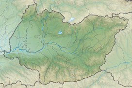
Likhi Range (Georgian: ლიხის ქედი, romanized: likhis kedi) or Surami Range (Georgian: სურამის ქედი, romanized: suramis kedi) is a mountain range in Georgia, a part of the Caucasus mountains. It connects the Greater Caucasus and Lesser Caucasus ranges and belongs to the Dzirulula denudative Plateau. It is watershed of the Black and Caspian seas basins and divides the country climatically and geomorphologically.[1]
The highest point in the range is the Ribisa mountain, at 2,470 m (8,100 ft) above sea level.[1] The lowest and most important mountain pass is the Surami Pass at an elevation of 949 m (3,114 ft) which links eastern and western Georgia. A railroad (in the tunnel) runs through the pass, as well as the Zestaponi-Khashuri highway. A southern portion of the Likhi range was historically known as Ghado.
See also
- Rikoti Pass
- Meskheti Range
References
- ^ a b Tielidze, Levan; Lominadze, George; Lezhava, Zaza; Gadrani, Lela; Javakhishvili, Alexander; Gobejishvili, Ramin. Tielidze, Levan (ed.). Geomorphology of Georgia. Springer. pp. 11, 191, 201, 203. ISBN 978-3-319-77764-1. Retrieved 9 October 2020.
- v
- t
- e


