List of California 14,000-foot summits
This is a complete list of the 12 summits with elevation higher than 14,000 feet (4,267 m) in the U.S. state of California, with at least 300 feet (91.44 meters) of topographic prominence. In mountaineering parlance, these peaks are known as fourteeners. The main fourteener article has a list of all of the fourteeners in the United States, as well as references, more information about how the list is determined, and caveats about accuracy.
The summit of a mountain or hill may be measured in three principal ways:
- The topographic elevation of a summit measures the height of the summit above a geodetic sea level.[a][b]
- The topographic prominence of a summit is a measure of how high the summit rises above its surroundings.[c][b]
- The topographic isolation (or radius of dominance) of a summit measures how far the summit lies from its nearest point of equal elevation.[1]
Summits higher than 14,000 feet
Map this section's coordinates using OpenStreetMap
Download coordinates as:
- KML
- GPX (all coordinates)
- GPX (primary coordinates)
- GPX (secondary coordinates)
The following sortable table comprises the 12 California summits with at least 14,000 feet (4267 meters) of elevation and at least 300 feet (91.44 meters) of topographic prominence.
| Rank | Mountain Peak | Mountain Range | Elevation | Prominence | Isolation | Location |
|---|---|---|---|---|---|---|
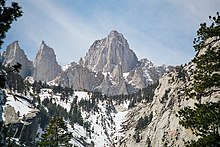
| 1 | Mount Whitney[2][3][4][d] | Sierra Nevada | 4421 m 14,505 ft | 3072 m 10,080 ft | 2,650.84 | 36°34′43″N 118°17′31″W / 36.5786°N 118.2920°W / 36.5786; -118.2920 (Mount Whitney) |
| 2 | Mount Williamson[5][6][e] | Sierra Nevada | 4383 m 14,379 ft | 511 m 1,676 ft | 8.75 km 5.44 mi | 36°39′21″N 118°18′40″W / 36.6559°N 118.3111°W / 36.6559; -118.3111 (Mount Williamson) |
| 3 | White Mountain Peak[7][8][9][f] | White Mountains | 4344 m 14,252 ft | 2193 m 7,196 ft | 108.7 km 67.5 mi | 37°38′03″N 118°15′21″W / 37.6341°N 118.2557°W / 37.6341; -118.2557 (White Mountain Peak) |
| 4 | North Palisade[10][11][12][g][h] | Sierra Nevada | 4343 m 14,248 ft | 882 m 2,894 ft | 51.9 km 32.3 mi | 37°05′39″N 118°30′52″W / 37.0943°N 118.5145°W / 37.0943; -118.5145 (North Palisade) |
| 5 | Mount Shasta[13][14][15][i] | Cascade Range | 4321.8 m 14,179 ft | 2979 m 9,772 ft | 539 km 335 mi | 41°24′33″N 122°11′42″W / 41.4092°N 122.1949°W / 41.4092; -122.1949 (Mount Shasta) |
| 6 | Mount Sill[16][17][j] | Sierra Nevada | 4316 m 14,159 ft | 114 m 373 ft | 1.02 km 0.63 mi | 37°05′46″N 118°30′12″W / 37.0960°N 118.5032°W / 37.0960; -118.5032 (Mount Sill) |
| 7 | Mount Russell[18][19][k] | Sierra Nevada | 4296 m 14,094 ft | 344 m 1,129 ft | 1.29 km 0.8 mi | 36°35′24″N 118°17′27″W / 36.5901°N 118.2908°W / 36.5901; -118.2908 (Mount Russell) |
| 8 | Split Mountain[20][21][22] | Sierra Nevada | 4286.6 m 14,064 ft | 421 m 1,380 ft | 9.92 km 6.16 mi | 37°01′15″N 118°25′21″W / 37.0209°N 118.4224°W / 37.0209; -118.4224 (Split Mountain) |
| 9 | Mount Langley[23][24][l] | Sierra Nevada | 4277 m 14,032 ft | 365 m 1,198 ft | 7.05 km 4.38 mi | 36°31′24″N 118°14′22″W / 36.5234°N 118.2395°W / 36.5234; -118.2395 (Mount Langley) |
| 10 | Mount Tyndall[25][26][m] | Sierra Nevada | 4275 m 14,025 ft | 343 m 1,125 ft | 2.31 km 1.44 mi | 36°39′20″N 118°20′13″W / 36.6556°N 118.3370°W / 36.6556; -118.3370 (Mount Tyndall) |
| 11 | Mount Muir[27][28][n] | Sierra Nevada | 4273 m 14,018 ft | 101 m 331 ft | 0.83 km 0.52 mi | 36°33′53″N 118°17′29″W / 36.5647°N 118.2913°W / 36.5647; -118.2913 (Mount Muir) |
| 12 | Middle Palisade[29][30][o] | Sierra Nevada | 4273 m 14,018 ft | 341 m 1,119 ft | 4.17 km 2.59 mi | 37°04′13″N 118°28′09″W / 37.0702°N 118.4691°W / 37.0702; -118.4691 (Middle Palisade) |
See also
 Geography portal
 North America portal
 United States portal
 California portal
 Mountains portal
 Volcanoes portal


- List of mountain peaks of North America
- List of mountain peaks of Greenland
- List of mountain peaks of Canada
- List of mountain peaks of the Rocky Mountains
- List of mountain peaks of the United States
- List of mountain peaks of Alaska
- List of mountain peaks of California
- List of the major 4000-meter summits of California
- List of the major 3000-meter summits of California
- List of California 14,000-foot summits
- List of mountain ranges of California
- List of mountain peaks of Colorado
- List of mountain peaks of Hawaiʻi
- List of mountain peaks of Montana
- List of mountain peaks of Nevada
- List of mountain peaks of Utah
- List of mountain peaks of Washington (state)
- List of mountain peaks of Wyoming
- List of mountain peaks of México
- List of mountain peaks of Central America
- List of mountain peaks of the Caribbean
- California
- Geography of California
- Category:Mountains of California
- commons:Category:Mountains of California
- Category:Mountains of California
- Geography of California
- Physical geography
Notes
- ^ All elevations in the 48 states of the contiguous United States include an elevation adjustment from the National Geodetic Vertical Datum of 1929 (NGVD 29) to the North American Vertical Datum of 1988 (NAVD 88). For further information, please see this United States National Geodetic Survey note.
- ^ a b If the elevation or prominence of a summit is calculated as a range of values, the arithmetic mean is shown.
- ^ The topographic prominence of a summit is the topographic elevation difference between the summit and its highest or key col to a higher summit. The summit may be near its key col or quite far away. The key col for Denali in Alaska is the Isthmus of Rivas in Nicaragua, 7642 kilometers (4749 miles) away.
- ^ The summit of Mount Whitney is the highest point of the Sierra Nevada, the State of California, and the contiguous United States.
- ^ The elevation of Mount Williamson includes an adjustment of +1.807 m (5.93 ft) from NGVD 29 to NAVD 88.
- ^ The summit of White Mountain Peak is the highest point of the White Mountains.
- ^ The summit of North Palisade is the highest point of the Palisades.
- ^ The elevation of North Palisade includes an adjustment of +1.867 m (6.13 ft) from NGVD 29 to NAVD 88.
- ^ The summit of Mount Shasta is the highest point of the southern Cascade Range.
- ^ The elevation of Mount Sill includes an adjustment of +1.888 m (6.19 ft) from NGVD 29 to NAVD 88.
- ^ The elevation of Mount Russell includes an adjustment of +1.869 m (6.13 ft) from NGVD 29 to NAVD 88.
- ^ The elevation of Mount Langley includes an adjustment of +1.76 m (5.77 ft) from NGVD 29 to NAVD 88.
- ^ The elevation of Mount Tyndall includes an adjustment of +1.835 m (6.02 ft) from NGVD 29 to NAVD 88.
- ^ The elevation of Mount Muir includes an adjustment of +1.857 m (6.09 ft) from NGVD 29 to NAVD 88.
- ^ The elevation of Middle Palisade includes an adjustment of +1.835 m (6.02 ft) from NGVD 29 to NAVD 88.
References
- ^ The topographic isolation of a summit is the great-circle distance to its nearest point of equal elevation.
- ^ "WHITNEY". Datasheet for NGS Station GT1811. U.S. National Geodetic Survey. Retrieved 3 March 2016.
- ^ "Mount Whitney". Peakbagger.com. Retrieved 3 March 2016.
- ^ "Mount Whitney". Bivouac.com. Retrieved 3 March 2016.
- ^ "Mount Williamson". Peakbagger.com. Retrieved 3 March 2016.
- ^ "Mount Williamson". Bivouac.com. Retrieved 3 March 2016.
- ^ "WHITE MOUNTAIN PEAK". Datasheet for NGS Station HR2559. U.S. National Geodetic Survey. Retrieved 3 March 2016.
- ^ "White Mountain Peak". Peakbagger.com. Retrieved 3 March 2016.
- ^ "White Mountain Peak". Bivouac.com. Retrieved 3 March 2016.
- ^ "NORTH PALISADE". Datasheet for NGS Station HR2629. U.S. National Geodetic Survey. Retrieved 3 March 2016.
- ^ "North Palisade". Peakbagger.com. Retrieved 3 March 2016.
- ^ "North Palisade". Bivouac.com. Retrieved 3 March 2016.
- ^ "MT SHASTA". Datasheet for NGS Station MX1016. U.S. National Geodetic Survey. Retrieved 3 March 2016.
- ^ "Mount Shasta". Peakbagger.com. Retrieved 3 March 2016.
- ^ "Mount Shasta". Bivouac.com. Retrieved 3 March 2016.
- ^ "Mount Sill". Peakbagger.com. Retrieved 3 March 2016.
- ^ "Mount Sill". Bivouac.com. Retrieved 3 March 2016.
- ^ "Mount Russell". Peakbagger.com. Retrieved 3 March 2016.
- ^ "Mount Russell". Bivouac.com. Retrieved 3 March 2016.
- ^ "SPLIT MTN". Datasheet for NGS Station HR2616. U.S. National Geodetic Survey. Retrieved 3 March 2016.
- ^ "Split Mountain". Peakbagger.com. Retrieved 3 March 2016.
- ^ "Split Mountain". Bivouac.com. Retrieved 3 March 2016.
- ^ "Mount Langley". Peakbagger.com. Retrieved 3 March 2016.
- ^ "Mount Langley". Bivouac.com. Retrieved 3 March 2016.
- ^ "Mount Tyndall". Peakbagger.com. Retrieved 3 March 2016.
- ^ "Mount Tyndall". Bivouac.com. Retrieved 3 March 2016.
- ^ "Mount Muir". Peakbagger.com. Retrieved 3 March 2016.
- ^ "Mount Muir". Bivouac.com. Retrieved 3 March 2016.
- ^ "Middle Palisade". Peakbagger.com. Retrieved 3 March 2016.
- ^ "Middle Palisade". Bivouac.com. Retrieved 3 March 2016.
External links
Mountains of California at Wikipedia's sister projects
 Media from Commons
 Texts from Wikisource
- United States Geological Survey (USGS)
- Geographic Names Information System @ USGS
- United States National Geodetic Survey (NGS)
- Geodetic Glossary @ NGS
- NGVD 29 to NAVD 88 online elevation converter @ NGS
- Survey Marks and Datasheets @ NGS
- Bivouac.com
- Peakbagger.com
- Peaklist.org
- Peakware.com
- Summitpost.org
- MapDEX - California 14ers
- VRMC California Thirteeners
- VRMC California Fourteeners
- v
- t
- e
State of California
Sacramento (capital)
- Antelope Valley
- Big Sur
- California Coast Ranges
- Cascade Range
- Central California
- Central Coast
- Central Valley
- Channel Islands
- Coachella Valley
- Coastal California
- Conejo Valley
- Cucamonga Valley
- Death Valley
- East Bay (SF Bay Area)
- East County (SD)
- Eastern California
- Emerald Triangle
- Gold Country
- Great Basin
- Greater San Bernardino
- Inland Empire
- Klamath Basin
- Lake Tahoe
- Greater Los Angeles
- Los Angeles Basin
- Lost Coast
- Mojave Desert
- Mountain Empire
- North Bay (SF)
- North Coast
- North County (SD)
- Northern California
- Orange Coast
- Owens Valley
- Oxnard Plain
- Peninsular Ranges
- Pomona Valley
- Sacramento–San Joaquin River Delta
- Sacramento Valley
- Saddleback Valley
- Salinas Valley
- San Fernando Valley
- San Francisco Bay Area
- San Francisco Peninsula
- San Gabriel Valley
- San Joaquin Valley
- Santa Clara Valley
- Santa Clara River Valley
- Santa Clarita Valley
- Santa Ynez Valley
- Shasta Cascade
- Sierra Nevada
- Silicon Valley
- South Bay (LA)
- South Bay (SD)
- South Bay (SF)
- South Coast
- Southern Border Region
- Southern California
- Transverse Ranges
- Tri-Valley
- Victor Valley
- Wine Country
- Alameda
- Alpine
- Amador
- Butte
- Calaveras
- Colusa
- Contra Costa
- Del Norte
- El Dorado
- Fresno
- Glenn
- Humboldt
- Imperial
- Inyo
- Kern
- Kings
- Lake
- Lassen
- Los Angeles
- Madera
- Marin
- Mariposa
- Mendocino
- Merced
- Modoc
- Mono
- Monterey
- Napa
- Nevada
- Orange
- Placer
- Plumas
- Riverside
- Sacramento
- San Benito
- San Bernardino
- San Diego
- San Francisco
- San Joaquin
- San Luis Obispo
- San Mateo
- Santa Barbara
- Santa Clara
- Santa Cruz
- Shasta
- Sierra
- Siskiyou
- Solano
- Sonoma
- Stanislaus
- Sutter
- Tehama
- Trinity
- Tulare
- Tuolumne
- Ventura
- Yolo
- Yuba
cities
 California portal
36°34′43″N 118°17′31″W / 36.5786°N 118.2920°W / 36.5786; -118.2920 (Mount Whitney)


