List of National Natural Landmarks in Ohio

Map
Map all coordinates using OpenStreetMap
Download coordinates as:
- KML
- GPX (all coordinates)
- GPX (primary coordinates)
- GPX (secondary coordinates)
From List of National Natural Landmarks, these are the National Natural Landmarks in Ohio. There are 23 in total.
| Name | Image | Date | Location | County | Ownership | Description | |
|---|---|---|---|---|---|---|---|
| 1 | Arthur B. Williams Memorial Woods | 1974 | 41°33′44″N 81°25′36″W / 41.562282°N 81.426792°W / 41.562282; -81.426792 (Arthur B. Williams Memorial Woods) | Cuyahoga | municipal | A remarkably pristine remnant beech-maple forest | |
| 2 | Blacklick Woods |  | 1974 | 39°56′14″N 82°48′28″W / 39.937222°N 82.807778°W / 39.937222; -82.807778 (Blacklick Woods) | Fairfield | county | An outstanding example of relatively undisturbed, old-growth beech-maple and swamp forest communities |
| 3 | Brown's Lake Bog |  | 1967 | 40°40′51″N 82°03′45″W / 40.6809°N 82.0624°W / 40.6809; -82.0624 (Brown's Lake Bog) | Wayne | private | One of the few well-preserved, virgin boreal acid bogs remaining in a region where wetlands have been drained for agricultural use. |
| 4 | Buzzardroost Rock, Lynx Prairie, The Wilderness |  | 1967 | 38°45′34″N 83°24′25″W / 38.759381°N 83.407013°W / 38.759381; -83.407013 (Lynx Prairie) | Adams | private | Supports many rare or uncommon species and it has an almost 50- year history of scientific observations. |
| 5 | Cedar Bog |  | 1967 | 40°03′34″N 83°47′44″W / 40.059444°N 83.795556°W / 40.059444; -83.795556 (Cedar Bog) | Champaign | state | An excellent example of a marl swamp. Part of Cedar Bog State Nature Preserve. |
| 6 | Clear Fork Gorge | 1967 | 40°36′40″N 82°17′13″W / 40.610982°N 82.286827°W / 40.610982; -82.286827 (Clear Fork Gorge) | Ashland | state | Clearly illustrates evidence of stream reversal due to the Wisconsin glacier. Located in Mohican State Park. | |
| 7 | Clifton Gorge |  | 1967 | 39°47′38″N 83°49′53″W / 39.793903°N 83.831525°W / 39.793903; -83.831525 (Clifton Gorge) | Greene | state | Exemplary of interglacial and postglacial canyon-cutting into the dolomites of the Niagara Escarpment. Part of Clifton Gorge State Nature Preserve. |
| 8 | Crall Woods | 1974 | 41°01′42″N 82°26′04″W / 41.028219°N 82.434376°W / 41.028219; -82.434376 (Crall Woods) | Ashland | private | A near-virgin remnant of maple-basswood-beech forest-type. | |
| 9 | Cranberry Bog |  | 1968 | 39°55′54″N 82°28′06″W / 39.931545°N 82.468232°W / 39.931545; -82.468232 (Cranberry Bog) | Licking | state | The only known bog of its type in existence. Part of Cranberry Bog State Nature Preserve. |
| 10 | Dysart Woods |  | 1967 | 39°59′05″N 80°59′51″W / 39.9846°N 80.9976°W / 39.9846; -80.9976 (Dysart Woods) | Belmont | state | One of the finest remaining examples of the white oak forests of eastern Ohio. Managed by Ohio University. |
| 11 | Fort Hill State Memorial |  | 1974 | Hillsboro39°06′47″N 83°24′23″W / 39.1131°N 83.4063°W / 39.1131; -83.4063 (Fort Hill State Memorial) | Highland | state | Excellent outcrops of Silurian, Devonian, and Mississippian sedimentary bedrock and a natural bridge. |
| 12 | Glacial Grooves State Memorial | 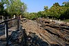 | 1967 | 41°36′59″N 82°42′23″W / 41.616304°N 82.70652°W / 41.616304; -82.70652 (Glacial Grooves State Memorial) | Erie | state | Very large limestone glacial grooves. |
| 13 | Glen Helen Natural Area |  | 1965 | 39°48′15″N 83°52′54″W / 39.804125°N 83.881697°W / 39.804125; -83.881697 (Glen Helen Natural Area) | Greene | private | Includes a waterfall that carved a large travertine bowl around its pool. |
| 14 | Goll Woods |  | 1974 | 41°33′15″N 84°21′42″W / 41.554294°N 84.361738°W / 41.554294; -84.361738 (Goll Woods) | Fulton | state | One of the best remaining examples of an oak-hickory dominated forest in Ohio. Part of Goll Woods State Nature Preserve. |
| 15 | Hazelwood Botanical Preserve | 1974 | Hamilton | state | Highly detailed study of the site's plant ecology was published in 1929. Managed by the University of Cincinnati. | ||
| 16 | Highbanks Natural Area |  | 1980 | 40°08′38″N 83°01′42″W / 40.143889°N 83.028333°W / 40.143889; -83.028333 (Highbanks Natural Area) | Delaware, Franklin | county | A forested bluff overlooking the Olentangy River. |
| 17 | Holden Natural Area | 1967 | Geauga, Lake | private | A complex of three natural areas. | ||
| 18 | Hueston Woods | 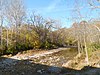 | 1967 | 39°34′21″N 84°44′29″W / 39.5725°N 84.741389°W / 39.5725; -84.741389 (Hueston Woods) | Butler, Preble | state | A noteworthy example of beech-maple climax forest that has never been cut. Located in Hueston Woods State Park. |
| 19 | Mantua Swamp | 1976 | 41°16′49″N 81°12′41″W / 41.280278°N 81.211389°W / 41.280278; -81.211389 (Mantua Swamp) | Portage | private | Contains many different wetland communities. | |
| 20 | Mentor Marsh |  | 1964 | 41°43′45″N 81°18′20″W / 41.729164°N 81.305492°W / 41.729164; -81.305492 (Mentor Marsh) | Lake | state | Consists of marsh vegetation, aquatic plants, swamp and bottomland forest, and upland forest. Part of Mentor Marsh State Nature Preserve. |
| 21 | Serpent Mound Cryptoexplosive Structure |  | 1980 | 39°02′00″N 83°24′00″W / 39.033333°N 83.4°W / 39.033333; -83.4 (Serpent Mound crater) | Adams, Highland, Pike | private | A structure of undetermined origin exposed by differential erosion. |
| 22 | Tinker's Creek Gorge |  | 1967 | 41°21′54″N 81°36′35″W / 41.365°N 81.609722°W / 41.365; -81.609722 (Tinker's Creek Gorge) | Cuyahoga | municipal | Contains a virgin oak-hickory and virgin beech-maple-hemlock forest. |
| 23 | White Pine Bog Forest | 1976 | Geauga | municipal, private | The only remaining near-virgin remnant white pine boreal bog in Ohio. |
See also
- v
- t
- e
Columbus (capital)
- Outline
- Climate change
- Geography
- Government
- History
- Law
- People
- Symbols
- Tourist attractions
- Portal
- Allegheny Plateau
- Appalachian Ohio
- The Bluegrass
- Glacial till plains
- Great Black Swamp
- Lake Erie (List of Lake Erie Islands)
- Mahoning Valley
- Miami Valley
- Northeast Ohio
- Northwest Ohio
- Vacationland
- Western Reserve
- Adams
- Allen
- Ashland
- Ashtabula
- Athens
- Auglaize
- Belmont
- Brown
- Butler
- Carroll
- Champaign
- Clark
- Clermont
- Clinton
- Columbiana
- Coshocton
- Crawford
- Cuyahoga
- Darke
- Defiance
- Delaware
- Erie
- Fairfield
- Fayette
- Franklin
- Fulton
- Gallia
- Geauga
- Greene
- Guernsey
- Hamilton
- Hancock
- Hardin
- Harrison
- Henry
- Highland
- Hocking
- Holmes
- Huron
- Jackson
- Jefferson
- Knox
- Lake
- Lawrence
- Licking
- Logan
- Lorain
- Lucas
- Madison
- Mahoning
- Marion
- Medina
- Meigs
- Mercer
- Miami
- Monroe
- Montgomery
- Morgan
- Morrow
- Muskingum
- Noble
- Ottawa
- Paulding
- Perry
- Pickaway
- Pike
- Portage
- Preble
- Putnam
- Richland
- Ross
- Sandusky
- Scioto
- Seneca
- Shelby
- Stark
- Summit
- Trumbull
- Tuscarawas
- Union
- Van Wert
- Vinton
- Warren
- Washington
- Wayne
- Williams
- Wood
- Wyandot
 Ohio portal


