List of bridges on the National Register of Historic Places in New Jersey
This is a list of bridges and tunnels on the National Register of Historic Places in the U.S. state of New Jersey.[1]
Current listings
| Name | Image | Built | Listed | Location | County | Type |
|---|---|---|---|---|---|---|
| Arch Bridge from the Boonton Ironworks |  | 1866 | 2022-09-01 | Boonton 40°54′23″N 74°24′58″W / 40.90639°N 74.41611°W / 40.90639; -74.41611 (Arch Bridge from the Boonton Ironworks) | Morris | Stone arch |
| Backwards Tunnel | 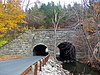 | 1871, 1872 | 2005-12-28 | Ogdensburg 41°5′16″N 74°36′6″W / 41.08778°N 74.60167°W / 41.08778; -74.60167 (Backwards Tunnel) | Sussex | Double stone arch |
| Bedens Brook Bridge | 1822 | 1994-02-17 | Rocky Hill 40°24′56″N 74°39′51″W / 40.41556°N 74.66417°W / 40.41556; -74.66417 (Bedens Brook Bridge) | Somerset | Stone arch | |
| Bedens Brook Road Bridge | ca. 1872, 1890 | 1994-02-18 | Stoutsburg 40°23′40″N 74°43′47″W / 40.39444°N 74.72972°W / 40.39444; -74.72972 (Bedens Brook Road Bridge) | Somerset | Stone arch | |
| Bonnie's Bridge | ca. 1790 | 1984-09-13 | Cherry Hill 39°54′39″N 75°0′18″W / 39.91083°N 75.00500°W / 39.91083; -75.00500 (Bonnie's Bridge) | Camden | Stone arch | |
| Bowne Station Road stone arch bridge over tributary of the Alexauken Creek | 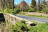 | 1837 | 2024-04-11 | Bowne 40°25′11.2″N 74°54′47.9″W / 40.419778°N 74.913306°W / 40.419778; -74.913306 (Bowne Station Road stone arch bridge over tributary of the Alexauken Creek) | Hunterdon | Stone arch |
| Canal Road over Six Mile Run part of the Delaware and Raritan Canal | 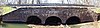 | 1834 | 1973-05-11 | Blackwells Mills 40°28′23″N 74°34′16″W / 40.47306°N 74.57111°W / 40.47306; -74.57111 (Canal Road over Six Mile Run) | Somerset | Triple stone arch |
| Cat Tail Brook Bridge | 1825 | 1979-08-01 | Rocky Hill 40°26′28″N 74°44′37″W / 40.44111°N 74.74361°W / 40.44111; -74.74361 (Cat Tail Brook Bridge) | Somerset | ||
| CR 616 over South Branch of Rancocas Creek part of the Vincentown Historic District | 1918 | 1988-09-21 | Southampton Township | Burlington | Steel stringer | |
| CR 681 over Stop the Jade Run part of the Vincentown Historic District | 1915 | 1988-09-21 | Southampton Township | Burlington | Stringer | |
| Dock Bridge |  | 1935 | 1980-10-03 | Newark 40°44′9″N 74°9′43″W / 40.73583°N 74.16194°W / 40.73583; -74.16194 (Dock Bridge) | Essex | Through-truss lift |
| Draw Bridge at New Bridge part of Historic New Bridge Landing |  | 1888, 1889 | 1989-07-05 | New Milford, River Edge, Teaneck 40°54′51″N 74°1′48″W / 40.91417°N 74.03000°W / 40.91417; -74.03000 (Draw Bridge at New Bridge) | Bergen | Pratt truss, listed in NJ and National Registers as oldest highway swing-bridge in NJ |
| Elm Street over Hackensack River part of the New Milford Plant of the Hackensack Water Company | 1892 | 2001-08-22 | Oradell 40°56′56.2″N 74°1′32.9″W / 40.948944°N 74.025806°W / 40.948944; -74.025806 (Elm Street over Hackensack River) | Bergen | Phoenix column Pratt pony truss | |
| Farnsworth Avenue over Robbinsville Secondary part of the Bordentown Historic District | ca. 1831 | 1982-06-14 | Bordentown | Burlington | Stone arch | |
| Fink-Type Truss Bridge | 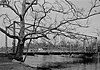 | 1857 | 1974-12-24 | Allerton 40°36′14″N 74°54′10″W / 40.60389°N 74.90278°W / 40.60389; -74.90278 (Fink-Type Truss Bridge) | Hunterdon | Fink truss, HAER NJ-18 |
| Foundry Road over North Branch of Rancocas Creek part of the Smithville Historic District | ca. 1885 | 1977-05-12 | Eastampton Township | Burlington | Stringer | |
| Frog Hollow Road Bridge over minor tributary of the South Branch Raritan River | 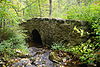 | by 1873 | 2002-12-12 | Tewksbury Township 40°43′48.4″N 74°49′6″W / 40.730111°N 74.81833°W / 40.730111; -74.81833 (Frog Hollow Road Bridge over minor tributary of the South Branch Raritan River) | Hunterdon | Stone arch |
| Glen Gardner Pony Pratt Truss Bridge |  | 1870 | 1977-09-22 | Glen Gardner 40°42′5″N 74°56′36″W / 40.70139°N 74.94333°W / 40.70139; -74.94333 (Glen Gardner Pony Pratt Truss Bridge) | Hunterdon | Pratt truss, HAER NJ-92 |
| Green Sergeants Covered Bridge | 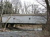 | 1872, 1961 | 1974-11-19 | Stockton 40°26′39″N 74°57′59″W / 40.44417°N 74.96639°W / 40.44417; -74.96639 (Green Sergeants Covered Bridge) | Hunterdon | Covered |
| Griggstown Causeway over Millstone River part of the Griggstown Historic District | 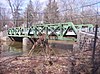 | 1903, 1938, 1978 | 1984-08-02 | Griggstown 40°26′21″N 74°37′05″W / 40.43917°N 74.61806°W / 40.43917; -74.61806 (Griggstown Causeway over Millstone River) | Somerset | Truss |
| Hardenburgh Avenue Bridge |  | 1909, 1911 | 2001-03-12 | Demarest Borough 40°57′24″N 73°57′48″W / 40.95667°N 73.96333°W / 40.95667; -73.96333 (Hardenburgh Avenue Bridge) | Bergen | Brick deck arch |
| Higginsville Road Bridges | 1889, 1890, 1893 | 2000-08-10 | Hillsborough 40°30′33″N 74°47′8″W / 40.50917°N 74.78556°W / 40.50917; -74.78556 (Higginsville Road Bridges) | Somerset | Truss | |
| Holland Tunnel |  | 1920, 1927 | 1993-11-04 | Jersey City | Hudson | Cast iron tunnel |
| Hollow Brook Road Bridge over tributary of the Lamington River |  | c. 1880 | 2002-12-12 | Tewksbury Township 40°43′2.3″N 74°44′10.5″W / 40.717306°N 74.736250°W / 40.717306; -74.736250 (Hollow Brook Road Bridge over tributary of the Lamington River) | Hunterdon | Truss |
| Kingston Bridge part of the Delaware and Raritan Canal, Kingston Mill Historic District, and King's Highway Historic District | 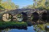 | 1798 | 1973-05-11 | Kingston | Mercer, Middlesex, Somerset | |
| Madison Avenue over Hackensack River part of the New Milford Plant of the Hackensack Water Company | 1902 | 2001-08-22 | New Milford | Bergen | Multi-girder | |
| Main Street Bridge (Califon, New Jersey) part of the Califon Historic District |  | 1887 | 1976-10-14 | Califon 40°43′14″N 74°50′15.5″W / 40.72056°N 74.837639°W / 40.72056; -74.837639 (Main Street Bridge) | Hunterdon | Pratt truss, HAER NJ-56 |
| Main Street Bridge (Clinton, New Jersey) part of the Clinton Historic District |  | 1870 | 1995-09-28 | Clinton 40°38′9.5″N 74°54′43.5″W / 40.635972°N 74.912083°W / 40.635972; -74.912083 (Main Street Bridge) | Hunterdon | Pratt truss, HAER NJ-19 |
| Main Street Bridge (CR 629) over Washington Secondary of DL&W RR part of the Port Murray Historic District | 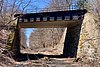 | 1914 | 1996-06-07 | Port Murray 40°47′08″N 74°54′58″W / 40.78556°N 74.91611°W / 40.78556; -74.91611 (Main Street Bridge, Port Murray) | Warren | Thru Girder |
| Mill Pond Bridge part of the Bridgepoint Historic District |  | c. 1820s | 1975-06-10 | Montgomery Township 40°26′04″N 74°38′42″W / 40.43444°N 74.64500°W / 40.43444; -74.64500 (Mill Pond Bridge) | Somerset | Stone arch |
| Mount Joy Road Bridge part of the Finesville–Seigletown Historic District |  | c. 1890 | 2010-11-10 | Finesville 40°36′21″N 75°10′14.5″W / 40.60583°N 75.170694°W / 40.60583; -75.170694 (Mount Joy Road Bridge, Finesville) | Hunterdon, Warren | Pratt truss |
| Neshanic Station Lenticular Truss Bridge part of the Neshanic Station Historic District | 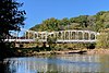 | 1896 | 2016-02-08 | Neshanic Station 40°30′34″N 74°43′37″W / 40.50944°N 74.72694°W / 40.50944; -74.72694 (Neshanic Station Lenticular Truss Bridge) | Somerset | Lenticular truss bridge, HAER NJ-31 |
| New Hampton Pony Pratt Truss Bridge |  | 1868 | 1977-07-26 | New Hampton 40°43′14″N 74°57′49″W / 40.72056°N 74.96361°W / 40.72056; -74.96361 (New Hampton Pony Pratt Truss Bridge) | Hunterdon, Warren | Pratt truss, HAER NJ-91 |
| Old Turnpike Road over Musconetcong River part of the Miller Farmstead historic district | 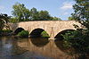 | 1860 | 1989-09-11 | Penwell 40°47′09″N 74°53′42″W / 40.78583°N 74.89500°W / 40.78583; -74.89500 (Old Turnpike Road over Musconetcong River) | Hunterdon, Warren | Triple Stone arch |
| Old Stone Arch Bridge |  | 1730 | 2008-06-27 | Bound Brook 40°33′38″N 74°31′37″W / 40.56056°N 74.52694°W / 40.56056; -74.52694 (Old Stone Arch Bridge) | Somerset | Stone arch |
| Palatine Road Bridge over a minor tributary of the Lamington River | 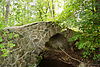 | 1900 | 2002-12-12 | Tewksbury Township 40°41′58.8″N 74°44′47.6″W / 40.699667°N 74.746556°W / 40.699667; -74.746556 (Palatine Road Bridge over a minor tributary of the Lamington River) | Hunterdon | Stone arch |
| Peck's Ferry Bridge | 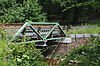 | 1900 | 1999-11-12 | Delaware Township 40°29′3″N 74°56′36.5″W / 40.48417°N 74.943472°W / 40.48417; -74.943472 (Peck's Ferry Bridge) | Hunterdon | Warren truss |
| Pennsylvania Railroad Bridge |  | 1903 | 1979-06-06 | Trenton 40°12′31″N 74°45′58″W / 40.20861°N 74.76611°W / 40.20861; -74.76611 (Pennsylvania Railroad Bridge) | Mercer | Stone arch |
| Plane Hill Road Bridge over Pohatcong Creek part of the Bowerstown Historic District | 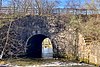 | c. 1830 | 1996-05-10 | Bowerstown 40°46′14″N 74°59′51″W / 40.77056°N 74.99750°W / 40.77056; -74.99750 (Plane Hill Bridge) | Warren | Stone arch |
| Pulaski Skyway part of the Route 1 Extension |  | 1932 | 2005-08-12 | Essex, Hudson | ||
| Race Street over South Branch of Rancocas Creek part of the Vincentown Historic District | 1909 | 1988-09-21 | Southampton Township | Burlington | Steel stringer | |
| Randolphville Bridge |  | 1937, 1939 | 1999-09-17 | Piscataway 40°32′22″N 74°27′11″W / 40.53944°N 74.45306°W / 40.53944; -74.45306 (Randolphville Bridge) | Middlesex | |
| Raritan Bridge |  | 1886 | 1992-11-12 | Raritan 40°33′53″N 74°38′9″W / 40.56472°N 74.63583°W / 40.56472; -74.63583 (Raritan Bridge) | Somerset | Pratt through truss |
| Raven Rock Road Bridge |  | 1878 | 2016-10-04 | Raven Rock 40°24′58.5″N 75°01′03.2″W / 40.416250°N 75.017556°W / 40.416250; -75.017556 (Raven Rock Road Bridge) | Hunterdon | Pratt truss |
| Rock Brook Bridge | 1825 | 1994-02-18 | Zion 40°26′22″N 74°44′23″W / 40.43944°N 74.73972°W / 40.43944; -74.73972 (Rock Brook Bridge) | Somerset | Stone arch | |
| Rockafellows Mill Bridge part of the Raritan–Readington South Branch Historic District |  | 1900 | 1990-01-26 | Rockefellows Mills 40°31′14″N 74°49′13″W / 40.52056°N 74.82028°W / 40.52056; -74.82028 (Rockafellows Mill Bridge) | Hunterdon | Pratt truss |
| Smithville Road over North Branch Rancocas Creek part of the Smithville Historic District | 1914 | 1977-05-12 | Eastampton Township | Burlington | Continuous concrete slab | |
| Smithville-Port Republic Road over Nacote Creek part of the Port Republic Historic District | 1904 | 1991-05-16 | Port Republic | Atlantic | Steel Warren pony truss swing | |
| Stone Sign Post Road Bridge over Plum Brook | 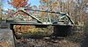 | 1903 | 2016-10-04 | Delaware Township 40°29′25.8″N 74°56′19.3″W / 40.490500°N 74.938694°W / 40.490500; -74.938694 (Stone Sign Post Road Bridge over Plum Brook) | Hunterdon | Warren truss |
| Strimple's Mill Road Bridge over Lockatong Creek | 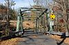 | 1897 | 2016-10-04 | Delaware Township 40°26′13.6″N 75°00′42.5″W / 40.437111°N 75.011806°W / 40.437111; -75.011806 (Strimple's Mill Road Bridge over Lockatong Creek) | Hunterdon | Pratt truss |
| Trenton City/Calhoun Street Bridge | 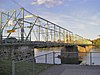 | 1885 | 1975-11-20 | Trenton 40°13′11″N 74°46′42″W / 40.21972°N 74.77833°W / 40.21972; -74.77833 (Trenton City/Calhoun Street Bridge) | Mercer | Phoenix column truss |
| Uhlerstown–Frenchtown Bridge part of the Frenchtown Historic District |  | 1931 | 1994-05-19 | Frenchtown 40°31′34″N 75°3′54″W / 40.52611°N 75.06500°W / 40.52611; -75.06500 (Uhlerstown–Frenchtown Bridge) | Hunterdon | Warren truss |
| US 40 & NJ 50 over Great Egg Harbor River part of the Mays Landing Historic District | 1928 | 1990-08-23 | Mays Landing | Atlantic | Concrete multi-girder | |
| US 40 & NJ 50 over Pleasantville Section RR part of the Mays Landing Historic District | 1929 | 1990-08-23 | Mays Landing | Atlantic | Steel stringer | |
| Warrington Stone Bridge |  | ca. 1860 | 1977-12-16 | Warrington 40°56′9″N 75°4′16.5″W / 40.93583°N 75.071250°W / 40.93583; -75.071250 (Warrington Stone Bridge) | Warren | Stone arch |
| Weymouth Road Bridge | 1920 | 2001-06-21 | Hamilton Township 39°31′7″N 74°46′45″W / 39.51861°N 74.77917°W / 39.51861; -74.77917 (Weymouth Road Bridge) | Atlantic | Steel Warren pony truss | |
| White Street over North Branch Rancocas Creek part of the Mount Holly Historic District | 1853 | 1973-02-20 | Mount Holly Township | Burlington | Brick elliptical arch | |
| Whitesbog Road over Pole Bridge Branch Canal part of the Whitesbog Historic District | 1935 | 1988-10-27 | Pemberton Township | Burlington | Concrete box culvert |
Former listings
| Name | Image | Built | Listed | Location | County | Type |
|---|---|---|---|---|---|---|
| Brielle Road Bridge over the Glimmer Glass | 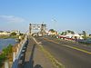 | 1938, 1950 | April 25, 2008 removed March 12, 2008 | Manasquan 40°6′42.79″N 74°2′44.77″W / 40.1118861°N 74.0457694°W / 40.1118861; -74.0457694 (Brielle Road Bridge over the Glimmer Glass) | Monmouth | Bascule |
References
- ^ "National Register Information System". National Register of Historic Places. National Park Service. July 9, 2010.
External links
Map all coordinates using OpenStreetMap
Download coordinates as:
- KML
- GPX (all coordinates)
- GPX (primary coordinates)
- GPX (secondary coordinates)
- "Historic Bridge Survey". New Jersey Department of Transportation.
- v
- t
- e
- Alabama
- Alaska
- Arizona
- Arkansas
- California
- Colorado
- Connecticut
- Delaware
- Florida
- Georgia
- Guam
- Hawaii
- Idaho
- Illinois
- Indiana
- Iowa
- Kansas
- Kentucky
- Louisiana
- Maine
- Maryland
- Massachusetts
- Michigan
- Minnesota
- Mississippi
- Missouri
- Montana
- Nebraska
- Nevada
- New Hampshire
- New Jersey
- New Mexico
- New York
- North Carolina
- North Dakota
- Ohio
- Oklahoma
- Oregon
- Pennsylvania
- Puerto Rico
- Rhode Island
- South Carolina
- South Dakota
- Tennessee
- Texas
- Utah
- Vermont
- Virginia
- Washington
- Washington, D.C.
- West Virginia
- Wisconsin
- Wyoming
| ||
|---|---|---|
| Topics |  | |
| Lists by county | ||
| Other lists | ||
| ||


