List of lighthouses in São Tomé and Príncipe
Map all coordinates using OpenStreetMap
Download coordinates as:
- KML
- GPX (all coordinates)
- GPX (primary coordinates)
- GPX (secondary coordinates)
This is a list of lighthouses in São Tomé and Príncipe.[1][2]
Lighthouses
| Name | Image | Year built | Location & coordinates | Class of Light [2] | Focal height [2] | NGA number [2] | Admiralty number [2] | Range nml [2] |
|---|---|---|---|---|---|---|---|---|
| Ana Chaves Range Rear Lighthouse | 1994 | São Tomé 0°21′24.9″N 6°43′33.6″E / 0.356917°N 6.726000°E / 0.356917; 6.726000 | Iso G 4s. | 9 metres (30 ft) | 25200 | D4234.1 | 6 | |
| Ilhéu Bom Bom Lighthouse | 1997 | Príncipe 1°41′58.7″N 7°24′09.7″E / 1.699639°N 7.402694°E / 1.699639; 7.402694 | Fl (2) WR 10s. | 64 metres (210 ft) | 25180 | D4158 | white: 12 red: 9 | |
| Ilhéu das Cabras Lighthouse |  | 1890 | São Tomé 0°24′32.6″N 6°42′58.7″E / 0.409056°N 6.716306°E / 0.409056; 6.716306 | Fl (2+1) W 15s. | 98 metres (322 ft) | 25184 | D4230 | 12 |
| Ilhéu Gago Coutinho Lighthouse | 1929 | São Tomé 0°00′22.1″N 6°31′11.3″E / 0.006139°N 6.519806°E / 0.006139; 6.519806 | Fl (2) W 10s. | 106 metres (348 ft) | 25204 | D4241 | 12 | |
| Lagoa Azul Lighthouse |  | 1997 | São Tomé 0°24′26.8″N 6°36′36.4″E / 0.407444°N 6.610111°E / 0.407444; 6.610111 | Fl (2) W 15s. | 34 metres (112 ft) | 25183 | D4243 | 12 |
| Ponta Furada Lighthouse | n/a | São Tomé 0°14′37.3″N 6°28′05.8″E / 0.243694°N 6.468278°E / 0.243694; 6.468278 | Fl W 8s. | 49 metres (161 ft) | 25205 | D4242 | 12 | |
| Pónta da Mina Lighthouse | 1996 | Príncipe 1°38′52.5″N 7°26′15.3″E / 1.647917°N 7.437583°E / 1.647917; 7.437583 | Fl (2) W 6s. | 54 metres (177 ft) | 25172 | D4154 | 9 | |
| Santo António do Príncipe Lighthouse | 1964 | Santo António 1°38′34.5″N 7°25′14.8″E / 1.642917°N 7.420778°E / 1.642917; 7.420778 | Fl (3) WRG 10s. | 13 metres (43 ft) | 25176 | D4155 | white: 9 red: 6 green: 6 | |
| São Sebastião Lighthouse | 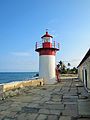 | 1928 | São Tomé 0°20′45.6″N 6°44′22.7″E / 0.346000°N 6.739639°E / 0.346000; 6.739639 | Fl (4) WR 12s. | 14 metres (46 ft) | 25192 | D4237 | white: 12 red: 9 |
See also
References
- ^ Rowlett, Russ. "Lighthouses of São Tomé and Príncipe". The Lighthouse Directory. University of North Carolina at Chapel Hill. Retrieved 2016-09-26.
- ^ a b c d e f List of Lights, Pub. 113: The West Coasts of Europe and Africa, the Mediterranean Sea, Black Sea and Azovskoye More (Sea of Azov) (PDF). List of Lights. United States National Geospatial-Intelligence Agency. 2016. Retrieved 26 September 2016
External links
Wikimedia Commons has media related to Lighthouses in São Tomé and Príncipe.
Rowlett, Russ. "The Lighthouse Directory". University of North Carolina at Chapel Hill.
Portals:
 São Tomé and Príncipe
 Engineering
 Architecture
 Lists
Lists


- v
- t
- e
| Construction |
|
|---|---|
| Navigational purpose |

- Lighthouse builders
- Lighthouses by heritage register
- Lighthouses by century of completion
- Lighthouses by year of completion
organizations
- General lighthouse authority
- International Association of Lighthouse Authorities
- Amateur Radio Lighthouse Society
- International Lighthouse and Lightship Weekend
- Lighthouse Digest
 Category
 Commons
 Wiktionary
 WikiProject

Lists of lighthouses in Africa | ||||||
|---|---|---|---|---|---|---|
| Sovereign states |
|  | ||||


