M6 motorway (Hungary)
Road in Hungary
You can help expand this article with text translated from the corresponding article in Hungarian. (February 2024) Click [show] for important translation instructions.
- Machine translation, like DeepL or Google Translate, is a useful starting point for translations, but translators must revise errors as necessary and confirm that the translation is accurate, rather than simply copy-pasting machine-translated text into the English Wikipedia.
- Do not translate text that appears unreliable or low-quality. If possible, verify the text with references provided in the foreign-language article.
- You must provide copyright attribution in the edit summary accompanying your translation by providing an interlanguage link to the source of your translation. A model attribution edit summary is
Content in this edit is translated from the existing Hungarian Wikipedia article at [[:hu:M6-os autópálya (Magyarország)]]; see its history for attribution. - You may also add the template
{{Translated|hu|M6-os autópálya (Magyarország)}}to the talk page. - For more guidance, see Wikipedia:Translation.
 | |
|---|---|
| M6-os autópálya | |
  in use in use  under construction under construction  other highways other highways | |
| Route information | |
Part of  | |
| Length | 193 km (120 mi) 212 km (132 mi) planned |
| Major junctions | |
| From |  M0 in Budapest M0 in Budapest |
| Major intersections |  M8 near Dunaújváros M8 near Dunaújváros M9 near Szekszárd M9 near Szekszárd M60 near Bóly M60 near Bóly |
| To | Ivándárda A5 border with A5 border with  Croatia Croatia |
| Location | |
| Country | Hungary |
| Counties | Pest, Fejér, Tolna, Baranya |
| Major cities | Budapest, Érd, Dunaújváros, Paks, Szekszárd, Mohács |
| Highway system | |
| |


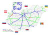
The M6 motorway (Hungarian: M6-os autópálya) is a north-south motorway in Hungary running along the Danube connecting Budapest to Mohács, and the section further south to the Croatia border is under construction
The southernmost Bóly - Ivándárda (border crossing with Croatia) section is currently under construction with a planned inauguration date in 2024.[1] The connecting segment of the A5 in Croatia is also under construction, with the completion scheduled for 2023.[2]
Municipalities
The M6 motorway runs through the following municipalities:
- Budapest, Érd, Százhalombatta
- Ercsi, Ráckeresztúr, Besnyő, Beloiannisz, Iváncsa, Adony, Kulcs, Rácalmás, Dunaújváros, Baracs, Daruszentmiklós, Előszállás
- Dunaföldvár, Bölcske, Paks, Dunaszentgyörgy, Fadd, Tengelic, Tolna, Fácánkert, Szedres, Szekszárd, Őcsény, Decs, Sárpilis, Várdomb, Alsónyék, Bátaszék
- Véménd, Palotabozsok, Szebény, Szűr, Himesháza, Székelyszabar, Kisnyárád, Lánycsók, Babarc
Openings timeline
- Budapest; M0 – Érdi-tető (7 km): 2008.09.23.
- Érdi-tető – Dunaújváros; M8 (68 km): 2006.06.11.
- Dunaújváros; M8 – Bóly; M60 (118 km): 2010.03.31.
Junctions, exits and rest areas
- Distance from Zero Kilometre Stone (Adam Clark Square) in Budapest in kilometres.
| km | Destinations | Route | Notes | |
|---|---|---|---|---|
| M0 (Budapest) – Ivándárda (212 km) | ||||
 | 15 km | Győr, Nagykanizsa / Szeged, Nyíregyháza Budapest International Airport | | Budapest bypass    |
 | 18 km | Érd east / Budapest-Nagytétény |  | |
| | 20 km | Érd-Ófalu |  | |
| | 22 km | Érdi-tető | | |
| | 25 km | Százhalombatta north | ||
| | 29 km | Százhalombatta south | ||
 Border of Pest and Fejér Counties Border of Pest and Fejér Counties | ||||
 | 31 km | Keresztúri rest area |  MOL + MOL +  | |
| | 34 km | Ráckeresztúr, Martonvásár / Ercsi | 6204 | |
| | 40 km | Fácános rest area | | |
| | 45 km | Besenyő, Pusztaszabolcs / Beloiannisz | 6205 | |
| | 50 km | Iváncsa / Pusztaszabolcs, Velence | 6207 | |
| | 55 km | Adony / Perkáta | 6208 | |
| | 57 km | Szentmihályi rest area | | |
| | 62 km | Kulcs, Rácalmás | ||
| | 67 km | Dunaújváros north / Székesfehérvár |  | |
| | 70 km | Dunaújváros / Mezőfalva, Sárbogárd | 6219 | |
| | 71 km | Újvárosi rest area | OMV / OMV +    | |
| | 75 km | Dunaújváros south, Szolnok / Szentgotthárd | | M8  turns toward -> Szolnok or turns toward -> Szolnok or   |
| | 83 km | Dunaföldvár north / Daruszentmiklós, Seregélyes | 6228 | |
| | 87 km | Dunaföldvár, Solt / Előszállás, Nagykanizsa |  | |
| Border of Fejér and Tolna Counties | ||||
| | 92 km | Dunaföldvári rest area | | |
| | 98 km | Dunaföldvár south, Paks north (Gabonásvölgy junction) | | |
 | Gyűrűs-árok | |||
| | Vörösmalmi-árok | |||
| | 106 km | Paks / Németkér, Cece | 6231 | |
| | 108 km | Paksi rest area | Mobil Petrol / Mobil Petrol + | |
| | 114 km | Paks south | 6232 | |
| | 120 km | Szentgyörgyi rest area | | |
| | 124 km | Tengelic / Dunaszentgyörgy, Fadd | 6234 | |
| | 131 km | Szedres | 631 | |
| | 134 km | Fácánkerti rest area | MOL / MOL +  | |
| | 138 km | Tolna | | |
| | 142 km | Szombathely, Nagykanizsa, Kaposvár / Szeged | | M9 turns toward -> Szombathely or Szeged |
 | Sió River | |||
| | 147 km | Szekszárd Centrum | 5113 | |
| | 151 km | Szekszárd south / Őcsény | 5114 | |
| | 155 km | Szentgyörgyi rest area | | |
| | 164 km | Bonyhád / Bátaszék, Baja |  | |
| | 165 km | Geresdi rest area | OMV / OMV + | |
 | 167-68 km | Bátaszék Tunnel "A" | Tunnel - 1331 m | |
| | 169 km | Belső-réti patak Viaduct | Bridge - 280 m | |
| | 169 km | Geresd Tunnel "B" | Tunnel - 399 m | |
| | 170 km | Belső-réti patak Viaduct | Bridge - 313 m | |
| Border of Tolna and Baranya Counties | ||||
| | 170-71 km | Baranya Tunnel "C" | Tunnel - 865 m | |
| | 172 km | Véménd Tunnel "D" | Tunnel - 418 m | |
| | 173 km | Palotabozsoki-vízfolyás Viaduct | Bridge - 481 m | |
| | Véménd, Pécsvárad / Palotabozsok, Somberek | 5606 | ||
| | Szebény Viaduct | Bridge - 830 m | ||
| | 181 km | Szebényi rest area | | |
| | Csele patak Viaduct | Bridge - 450 m | ||
| | Himesházai-árok Viaduct | Bridge - 491 m | ||
| | 191 km | Lánycsók, Mohács / Babarc |  | |
| | 193 km | Pécs, Barcs  | | M60 turns toward ->  |
| Signs | Distance | Destinations | Note |
|---|---|---|---|
 | (196 km) | Nagynyárád, Bóly - East | |
| (210 km) | Ivándárda, Kislippó | |
 |  (212 km) (212 km) | Ivándárda / Branjin Vrh border crossing | |
   | Osijek, Croatia |
Toll
From February 1, 2015, the M6 motorway is a toll-road. The motorway can be used with the national sticker or with the following county stickers:
| Type of vignette | Available section |
|---|---|
| Pest County | between M0 expressway junction and Ráckeresztúr (15 km – 34 km) |
| Fejér County | between Százhalombatta north and Paks north (25 km – 98 km) |
| Tolna County | between M8 motorway junction and Pécsvárad (Somberek) (75 km – 173 km) |
| Baranya County | between Bátaszék and Bóly west (163 km – 191 km) |
Significant structures
From Budapest to the Croatian border, the M6 motorway features the following bridges, tunnels or covered cuts:
- Viaducts
- Belső-réti patak Viaduct (Belső-réti patak völgyhíd I.; 280 m or 920 ft)
- Belső-réti patak Viaduct (Belső-réti patak völgyhíd II.; 313 m or 1,027 ft)
- Palotabozsoki-vízfolyás Viaduct (Palotabozsoki-vízfolyás völgyhíd; 481 m or 1,578 ft)
- Szebény Viaduct (Szebényi völgyhíd; 830 m or 2,720 ft)
- Csele patak Viaduct (Csele-patak völgyhíd; 450 m or 1,480 ft)
- Himesházai árok Viaduct (Himesházai árok völgyhíd; 491 m or 1,611 ft)
- Tunnels
- Bátaszék Tunnel (Bátaszék alagút "A"; 1,331 m or 4,367 ft) – Longest tunnel in Hungary
- Geresd Tunnel (Geresd alagút "B"; 399 m or 1,309 ft)
- Baranya Tunnel (Baranya alagút "C"; 865 m or 2,838 ft)
- Véménd Tunnel (Véménd alagút "D"; 418 m or 1,371 ft)
European Route
| Name | Route | |
| | 197 km | junction  (15) – Autocesta A5 (15) – Autocesta A5 |
See also
 Hungary portal
 Roads portal


References
External links
Wikimedia Commons has media related to Autópálya M6.
- National Toll Payment Services Plc. (in Hungarian, some information also in English)
- National Infrastructure Developer Ltd. (in Hungarian)
- Exit list of M6 in motorways-exits.com
- Construction works of the new section
- v
- t
- e

- M0
- M1
- M3
- M4
- M5
- M6
- M7
- M8
- M15
- M30
- M31
- M35
- M43
- M44
- M60
- M70

- M2
- M4
- M9
- M19
- M25
- M51
- M76
- M80
- M85
- M86
- R67
- M10
- M32
- M34
- M49
- M81
- M83
- M87
- M90
- M100
- Southern highway
- R8
- R21
- R47
- R83


