Maków County
You can help expand this article with text translated from the corresponding article in Polish. (July 2016) Click [show] for important translation instructions.
- Machine translation, like DeepL or Google Translate, is a useful starting point for translations, but translators must revise errors as necessary and confirm that the translation is accurate, rather than simply copy-pasting machine-translated text into the English Wikipedia.
- Consider adding a topic to this template: there are already 1,471 articles in the main category, and specifying
|topic=will aid in categorization. - Do not translate text that appears unreliable or low-quality. If possible, verify the text with references provided in the foreign-language article.
- You must provide copyright attribution in the edit summary accompanying your translation by providing an interlanguage link to the source of your translation. A model attribution edit summary is
Content in this edit is translated from the existing Polish Wikipedia article at [[:pl:Powiat makowski]]; see its history for attribution. - You may also add the template
{{Translated|pl|Powiat makowski}}to the talk page. - For more guidance, see Wikipedia:Translation.
County in Masovian Voivodeship, Poland
Maków County Powiat makowski | |
|---|---|
County | |
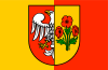 Flag 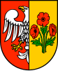 Coat of arms | |
 Location within the voivodeship | |
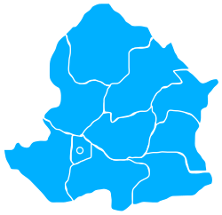 Division into gminas | |
| Coordinates (Maków Mazowiecki): 52°52′N 21°6′E / 52.867°N 21.100°E / 52.867; 21.100 | |
| Country |  Poland Poland |
| Voivodeship | Masovian |
| Seat | Maków Mazowiecki |
| Gminas | Total 10 (incl. 1 urban)
|
| Area | |
| • Total | 1,064.56 km2 (411.03 sq mi) |
| Population (2019) | |
| • Total | 45,076 |
| • Density | 42/km2 (110/sq mi) |
| • Urban | 12,485 |
| • Rural | 32,591 |
| Car plates | WMA |
| Website | http://www.powiat-makowski.pl |
Maków County (Polish: powiat makowski) is a unit of territorial administration and local government (powiat) in Masovian Voivodeship, east-central Poland. It came into being on January 1, 1999, as a result of the Polish local government reforms passed in 1998. Its administrative seat and largest town is Maków Mazowiecki, which lies 73 kilometres (45 mi) north of Warsaw. The only other town in the county is Różan, lying 20 km (12 mi) east of Maków Mazowiecki.
The county covers an area of 1,064.56 square kilometres (411.0 sq mi). As of 2019 its total population is 45,076, out of which the population of Maków Mazowiecki is 9,776, that of Różan is 2,709, and the rural population is 32,591.[1]
Neighbouring counties
Maków County is bordered by Ostrołęka County to the north-east, Wyszków County to the south-east, Pułtusk County to the south, Ciechanów County to the west and Przasnysz County to the north-west.
Administrative division
The county is subdivided into 10 gminas (one urban, one urban-rural and eight rural). These are listed in the following table, in descending order of population.
| Gmina | Type | Area (km2) | Population (2019) | Seat |
| Maków Mazowiecki | urban | 10.3 | 9,776 | |
| Gmina Krasnosielc | rural | 167.0 | 6,399 | Krasnosielc |
| Gmina Płoniawy-Bramura | rural | 135.0 | 5,363 | Płoniawy-Bramura |
| Gmina Karniewo | rural | 129.4 | 5,189 | Karniewo |
| Gmina Różan | urban-rural | 84.1 | 4,411 | Różan |
| Gmina Szelków | rural | 112.9 | 3,659 | Szelków |
| Gmina Sypniewo | rural | 128.6 | 3,270 | Sypniewo |
| Gmina Rzewnie | rural | 111.7 | 2,625 | Rzewnie |
| Gmina Czerwonka | rural | 110.6 | 2,644 | Czerwonka |
| Gmina Młynarze | rural | 75.0 | 1,740 | Młynarze |
References
- ^ GUS. "Population. Size and structure and vital statistics in Poland by territorial division in 2019. As of 30th June". stat.gov.pl. Retrieved 2020-09-14.

Counties of the Masovian Voivodeship | ||
|---|---|---|
| City counties |  | |
| Land counties |
| |


