Mann Mound
Archaeological site in Ohio, United States
United States historic place
Mann Mound | |
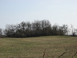 Overview of the mound from the north | |
39°33′5.4″N 84°29′42″W / 39.551500°N 84.49500°W / 39.551500; -84.49500 | |
| Area | 1 acre (0.40 ha) |
|---|---|
| NRHP reference No. | 71000632[1] |
| Added to NRHP | October 7, 1971 |
The Mann Mound is a Native American mound in the southwestern part of the U.S. state of Ohio. Located near the unincorporated community of Jacksonburg in Butler County,[1] it is tree-covered and sits on the edge of a field[4] in Section 12 of Wayne Township. Its height is approximately 20 feet (6.1 m), and its circumference is approximately 540 feet (160 m).[2]
In November 1868, the mound was quarried for gravel by local residents; this excavation continued until the miners had reached the center of the mound, where they found multiple limestone burial vaults. These vaults were built as squares, 3 feet (0.91 m) on each side; each contained a skeleton that had presumably been placed in a seated position. The vaults were stacked from the mound's floor to a position just underneath its summit; each was separated from others by a small amount of gravel. Eight skeletons were removed from these vaults and sent to the Smithsonian Institution.[2] Findings from the mound have led to the conclusion that it is a work of the Adena culture.[1]
Despite the damage done by the amateur excavation, the Mann Mound is still a significant archaeological site and the second largest extant mound in Butler County. It was recorded by an archaeological survey published by J.P. MacLean in 1879,[4] and in 1971, it was recognized for its archaeological significance when it was listed on the National Register of Historic Places.[1]
References
- ^ a b c d "National Register Information System". National Register of Historic Places. National Park Service. March 13, 2009.
- ^ a b c MacLean, J. P. The Mound Builders: Being an Account of a Remarkable People that Once Inhabited the Valleys of the Ohio and Mississippi, Together with an Investigation Into the Archæology of Butler County, O. Cincinnati: Clarke, 1879, 221.
- ^ Mills, William C. Archeological Atlas of Ohio. Columbus: Ohio State Archeological and Historical Society, 1914, page 9 and plate 9.
- ^ a b Owen, Lorrie K., ed. Dictionary of Ohio Historic Places. Vol. 1. St. Clair Shores: Somerset, 1999, 98.
- v
- t
- e

- Periods
- Lithic
- Archaic
- Formative
- Classic
- Post-Classic
cultures
- Adena
- Alachua
- Ancient Beringian
- Ancestral Pueblo (Anasazi)
- Avonlea
- Baytown
- Belle Glade
- Buttermilk Creek complex
- Caborn-Welborn
- Cades Pond
- Calf Creek
- Caloosahatchee
- Clovis
- Coles Creek
- Comondú
- Deptford
- Folsom
- Fort Ancient
- Fort Walton
- Fremont
- Glacial Kame
- Glades
- Hohokam
- Hopewell
- La Jolla
- Las Palmas
- Maritime Archaic
- Mississippian
- Mogollon
- Monongahela
- Old Cordilleran
- Oneota
- Paleo-Arctic
- Paleo-Indians
- Patayan
- Plano
- Plaquemine
- Poverty Point
- Red Ocher
- Safety Harbor
- Santa Rosa-Swift Creek
- St. Johns
- Steed-Kisker
- Suwannee Valley
- Tchefuncte
- Troyville
- Weeden Island
sites
- Angel Mounds
- Anzick site
- Bandelier National Monument
- Bastian
- Benson
- Blue Spring Shelter
- Bluefish Caves
- The Bluff Point Stoneworks
- Brewster
- Cahokia
- Candelaria Cave
- Casa Grande
- Chaco Canyon
- Coso Rock Art District
- Crystal River
- Cuarenta Casas
- Cueva de la Olla
- Cutler
- Eaker
- El Fin del Mundo
- El Vallecito
- Effigy Mounds
- Etowah Indian Mounds
- Eva
- Folsom
- Fort Ancient
- Fort Center
- Fort Juelson
- Four Mounds
- Gila Cliff Dwellings
- Glenwood
- Grimes Point
- Helen Blazes
- Holly Bluff
- Hopewell Culture National Historical Park
- Horr's Island
- Huápoca
- Key Marco
- Kimball Village
- Kincaid Mounds
- Kolomoki Mounds
- Lake Jackson Mounds
- Lehner Mammoth-Kill Site
- L'Anse aux Meadows
- Lynch Quarry Site
- Marksville
- Marmes Rockshelter
- Meadowcroft Rockshelter
- Mesa Verde
- Moaning Cavern
- Moorehead Circle
- Morrison Mounds
- Moundville
- Mummy Cave
- Nodena site
- Ocmulgee Mounds
- Old Stone Fort
- Orwell site
- Paquime
- Painted Bluff
- Parkin Park
- Pinson Mounds
- Plum Bayou Mounds
- Portsmouth Earthworks
- Poverty Point
- Pueblo Bonito
- Recapture Canyon
- River Styx
- Roberts Island
- Rock Eagle
- Rock Hawk
- Rosenstock Village
- Russell Cave
- Salmon Ruins
- Serpent Mound
- Sierra de San Francisco
- Shell ring sites
- Spiro Mounds
- Stallings Island
- SunWatch
- Taos Pueblo
- Town Creek Indian Mound
- Turkey River Mounds
- Upward Sun River
- Velda Mound
- West Oak Forest Earthlodge
- Wickiup Hill
- Windover
- Winterville
- Wupatki
remains
- Aridoamerica
- Ballgame
- Black drink
- Ceremonial pipe
- Chunkey
- Clovis point
- Container Revolution
- Eastern Agricultural Complex
- Eden point
- Effigy mound
- Falcon dancer
- Folsom point
- Green Corn Ceremony
- Horned Serpent
- Kiva
- Medicine wheel
- Metallurgy
- Mi'kmaq hieroglyphic writing
- Mound Builders
- N.A.G.P.R.A.
- Norse colonization of North America
- Oasisamerica
- Piasa
- Projectile point
- Southeastern Ceremonial Complex
- Stickball
- Three Sisters agriculture
- Thunderbird
- Transoceanic contact
- Underwater panther
- Water glyphs
- Related
- Genetic history
- Pre-Columbian era
| |
|---|---|
| Topics | |
| Lists by state |
|
| Lists by insular areas | |
| Lists by associated state | |
| Other areas | |
| Related | |
| |


