Mingoval
Commune in Hauts-de-France, France

Coat of arms
Location of Mingoval

(2020–2026) Sidonie Duriez[1]
1
(2021)[2]
62574 /62690
(avg. 125 m or 410 ft)
Mingoval (French pronunciation: [mɛ̃ɡɔval]) is a commune in the Pas-de-Calais department in the Hauts-de-France region of France.[3]
Geography
Mingoval is situated 12 miles (19 km) northwest of Arras, on the D73 road.
Population
| Year | Pop. | ±% p.a. |
|---|---|---|
| 1968 | 201 | — |
| 1975 | 196 | −0.36% |
| 1982 | 183 | −0.98% |
| 1990 | 207 | +1.55% |
| 1999 | 208 | +0.05% |
| 2007 | 202 | −0.37% |
| 2012 | 221 | +1.81% |
| 2017 | 230 | +0.80% |
| Source: INSEE[4] | ||
Places of interest
- The church of St.Liévin, dating from the eighteenth century.
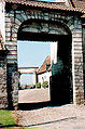
- The seventeenth century cemetery entrance.
- An old farmhouse.
See also
References
- ^ "Répertoire national des élus: les maires" (in French). data.gouv.fr, Plateforme ouverte des données publiques françaises. 13 September 2022.
- ^ "Populations légales 2021". The National Institute of Statistics and Economic Studies. 28 December 2023.
- ^ INSEE commune file
- ^ Population en historique depuis 1968, INSEE
Wikimedia Commons has media related to Mingoval.
-
 Ancient entrance to the old farm
 -
 The churchyard entrance
 -
 The church spire
 -
 Architectural detail
 -
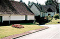 Typical regional houses
 -
 The church


- v
- t
- e
Communes of the Pas-de-Calais department
- Ablain-Saint-Nazaire
- Ablainzevelle
- Acheville
- Achicourt
- Achiet-le-Grand
- Achiet-le-Petit
- Acq
- Acquin-Westbécourt
- Adinfer
- Affringues
- Agnez-lès-Duisans
- Agnières
- Agny
- Aire-sur-la-Lys
- Airon-Notre-Dame
- Airon-Saint-Vaast
- Aix-en-Ergny
- Aix-en-Issart
- Aix-Noulette
- Alembon
- Alette
- Alincthun
- Allouagne
- Alquines
- Ambleteuse
- Ambricourt
- Ambrines
- Ames
- Amettes
- Amplier
- Andres
- Angres
- Annay
- Annequin
- Annezin
- Anvin
- Anzin-Saint-Aubin
- Ardres
- Arleux-en-Gohelle
- Arques
- Arraspref
- Athies
- Les Attaques
- Attin
- Aubigny-en-Artois
- Aubin-Saint-Vaast
- Aubrometz
- Auchel
- Auchy-au-Bois
- Auchy-lès-Hesdin
- Auchy-les-Mines
- Audembert
- Audincthun
- Audinghen
- Audrehem
- Audresselles
- Audruicq
- Aumerval
- Autingues
- Auxi-le-Château
- Averdoingt
- Avesnes
- Avesnes-le-Comte
- Avesnes-lès-Bapaume
- Avion
- Avondance
- Avroult
- Ayette
- Azincourt
- Bailleul-aux-Cornailles
- Bailleul-lès-Pernes
- Bailleulmont
- Bailleul-Sir-Berthoult
- Bailleulval
- Baincthun
- Bainghen
- Bajus
- Balinghem
- Bancourt
- Bapaume
- Baralle
- Barastre
- Barlin
- Barly
- Basseux
- Bavincourt
- Bayenghem-lès-Éperlecques
- Bayenghem-lès-Seninghem
- Bazinghen
- Béalencourt
- Beaudricourt
- Beaufort-Blavincourt
- Beaulencourt
- Beaumerie-Saint-Martin
- Beaumetz-lès-Aire
- Beaumetz-lès-Cambrai
- Beaumetz-lès-Loges
- Beaurains
- Beaurainville
- Beauvoir-Wavans
- Beauvois
- Bécourt
- Béhagnies
- Bellebrune
- Belle-et-Houllefort
- Bellinghem
- Bellonne
- Bénifontaine
- Berck
- Bergueneuse
- Berlencourt-le-Cauroy
- Berles-au-Bois
- Berles-Monchel
- Bermicourt
- Berneville
- Bernieulles
- Bertincourt
- Béthonsart
- Béthunesubpr
- Beugin
- Beugnâtre
- Beugny
- Beussent
- Beutin
- Beuvrequen
- Beuvry
- Bezinghem
- Biache-Saint-Vaast
- Biefvillers-lès-Bapaume
- Bienvillers-au-Bois
- Bihucourt
- Billy-Berclau
- Billy-Montigny
- Bimont
- Blairville
- Blangerval-Blangermont
- Blangy-sur-Ternoise
- Blendecques
- Bléquin
- Blessy
- Blingel
- Boffles
- Boiry-Becquerelle
- Boiry-Notre-Dame
- Boiry-Sainte-Rictrude
- Boiry-Saint-Martin
- Bois-Bernard
- Boisdinghem
- Boisjean
- Boisleux-au-Mont
- Boisleux-Saint-Marc
- Bomy
- Bonnières
- Bonningues-lès-Ardres
- Bonningues-lès-Calais
- Boubers-lès-Hesmond
- Boubers-sur-Canche
- Bouin-Plumoison
- Boulogne-sur-Mersubpr
- Bouquehault
- Bourecq
- Bouret-sur-Canche
- Bourlon
- Bournonville
- Bours
- Boursin
- Bourthes
- Bouvelinghem
- Bouvigny-Boyeffles
- Boyaval
- Boyelles
- Brebières
- Brêmes
- Brévillers
- Bréxent-Énocq
- Brias
- Brimeux
- Bruay-la-Buissière
- Brunembert
- Bucquoy
- Buire-au-Bois
- Buire-le-Sec
- Buissy
- Bullecourt
- Bully-les-Mines
- Buneville
- Burbure
- Bus
- Busnes
- Caffiers
- Cagnicourt
- Calaissubpr
- Calonne-Ricouart
- Calonne-sur-la-Lys
- La Calotterie
- Camblain-Châtelain
- Camblain-l'Abbé
- Cambligneul
- Cambrin
- Camiers
- Campagne-lès-Boulonnais
- Campagne-lès-Guines
- Campagne-lès-Hesdin
- Campagne-lès-Wardrecques
- Campigneulles-les-Grandes
- Campigneulles-les-Petites
- Canettemont
- Canlers
- Capelle-Fermont
- La Capelle-lès-Boulogne
- Capelle-lès-Hesdin
- Carency
- Carly
- Carvin
- La Cauchie
- Cauchy-à-la-Tour
- Caucourt
- Caumont
- Cavron-Saint-Martin
- Chelers
- Chériennes
- Chérisy
- Chocques
- Clairmarais
- Clenleu
- Clerques
- Cléty
- Colembert
- Colline-Beaumont
- La Comté
- Conchil-le-Temple
- Conchy-sur-Canche
- Condette
- Contes
- Conteville-en-Ternois
- Conteville-lès-Boulogne
- Coquelles
- Corbehem
- Cormont
- Couin
- Coullemont
- Coulogne
- Coulomby
- Coupelle-Neuve
- Coupelle-Vieille
- Courcelles-le-Comte
- Courcelles-lès-Lens
- Courrières
- Courset
- La Couture
- Couturelle
- Coyecques
- Crémarest
- Crépy
- Créquy
- Croisette
- Croisilles
- Croix-en-Ternois
- Cucq
- Cuinchy
- Dainville
- Dannes
- Delettes
- Denier
- Dennebrœucq
- Desvres
- Diéval
- Divion
- Dohem
- Douchy-lès-Ayette
- Doudeauville
- Dourges
- Douriez
- Douvrin
- Drocourt
- Drouvin-le-Marais
- Duisans
- Dury
- Echinghen
- Éclimeux
- Écoivres
- Écourt-Saint-Quentin
- Écoust-Saint-Mein
- Ecquedecques
- Ecques
- Écuires
- Écurie
- Éleu-dit-Leauwette
- Elnes
- Embry
- Enquin-lez-Guinegatte
- Enquin-sur-Baillons
- Éperlecques
- Épinoy
- Eps
- Équihen-Plage
- Équirre
- Ergny
- Érin
- Erny-Saint-Julien
- Ervillers
- Escalles
- Escœuilles
- Esquerdes
- Essars
- Estevelles
- Estrée
- Estrée-Blanche
- Estrée-Cauchy
- Estrée-Wamin
- Estréelles
- Étaing
- Étaples
- Éterpigny
- Étrun
- Évin-Malmaison
- Famechon
- Fampoux
- Farbus
- Fauquembergues
- Favreuil
- Febvin-Palfart
- Ferfay
- Ferques
- Festubert
- Feuchy
- Ficheux
- Fiefs
- Fiennes
- Fillièvres
- Fléchin
- Flers
- Fleurbaix
- Fleury
- Floringhem
- Foncquevillers
- Fontaine-lès-Boulans
- Fontaine-lès-Croisilles
- Fontaine-lès-Hermans
- Fontaine-l'Étalon
- Fortel-en-Artois
- Fosseux
- Foufflin-Ricametz
- Fouquereuil
- Fouquières-lès-Béthune
- Fouquières-lès-Lens
- Framecourt
- Frémicourt
- Frencq
- Fresnes-lès-Montauban
- Fresnicourt-le-Dolmen
- Fresnoy
- Fresnoy-en-Gohelle
- Fressin
- Fréthun
- Frévent
- Frévillers
- Frévin-Capelle
- Fruges
- Galametz
- Gauchin-Légal
- Gauchin-Verloingt
- Gaudiempré
- Gavrelle
- Gennes-Ivergny
- Givenchy-en-Gohelle
- Givenchy-le-Noble
- Givenchy-lès-la-Bassée
- Gomiécourt
- Gommecourt
- Gonnehem
- Gosnay
- Gouves
- Gouy-en-Artois
- Gouy-en-Ternois
- Gouy-Saint-André
- Gouy-Servins
- Gouy-sous-Bellonne
- Graincourt-lès-Havrincourt
- Grand-Rullecourt
- Grenay
- Grévillers
- Grigny
- Grincourt-lès-Pas
- Groffliers
- Guarbecque
- Guémappe
- Guemps
- Guigny
- Guinecourt
- Guînes
- Guisy
- Habarcq
- Haillicourt
- Haisnes
- Halinghen
- Hallines
- Halloy
- Ham-en-Artois
- Hamblain-les-Prés
- Hamelincourt
- Hames-Boucres
- Hannescamps
- Haplincourt
- Haravesnes
- Hardinghen
- Harnes
- Haucourt
- Haute-Avesnes
- Hautecloque
- Hauteville
- Haut-Loquin
- Havrincourt
- Hébuterne
- Helfaut
- Hendecourt-lès-Cagnicourt
- Hendecourt-lès-Ransart
- Hénin-Beaumont
- Hénin-sur-Cojeul
- Héninel
- Henneveux
- Hénu
- Herbinghen
- Héricourt
- La Herlière
- Herlincourt
- Herlin-le-Sec
- Herly
- Hermaville
- Hermelinghen
- Hermies
- Hermin
- Hernicourt
- Hersin-Coupigny
- Hervelinghen
- Hesdigneul-lès-Béthune
- Hesdigneul-lès-Boulogne
- Hesdin
- Hesdin-l'Abbé
- Hesmond
- Hestrus
- Heuchin
- Heuringhem
- Hézecques
- Hinges
- Hocquinghen
- Houchin
- Houdain
- Houlle
- Houvin-Houvigneul
- Hubersent
- Huby-Saint-Leu
- Huclier
- Hucqueliers
- Hulluch
- Humbercamps
- Humbert
- Humerœuille
- Humières
- Inchy-en-Artois
- Incourt
- Inxent
- Isbergues
- Isques
- Ivergny
- Izel-lès-Équerchin
- Izel-lès-Hameau
- Journy
- Labeuvrière
- Labourse
- Labroye
- Lacres
- Lagnicourt-Marcel
- Laires
- Lambres
- Landrethun-le-Nord
- Landrethun-lès-Ardres
- Lapugnoy
- Lattre-Saint-Quentin
- Laventie
- Lebiez
- Lebucquière
- Léchelle
- Ledinghem
- Lefaux
- Leforest
- Lenssubpr
- Lépine
- Lespesses
- Lespinoy
- Lestrem
- Leubringhen
- Leulinghem
- Leulinghen-Bernes
- Libercourt
- Licques
- Liencourt
- Lières
- Liettres
- Liévin
- Lignereuil
- Ligny-lès-Aire
- Ligny-Saint-Flochel
- Ligny-sur-Canche
- Ligny-Thilloy
- Lillers
- Linghem
- Linzeux
- Lisbourg
- Locon
- La Loge
- Loison-sous-Lens
- Loison-sur-Créquoise
- Longfossé
- Longuenesse
- Longueville
- Longvilliers
- Loos-en-Gohelle
- Lorgies
- Lottinghen
- Louches
- Lozinghem
- Lugy
- Lumbres
- La Madelaine-sous-Montreuil
- Magnicourt-en-Comte
- Magnicourt-sur-Canche
- Maintenay
- Maisnil
- Maisnil-lès-Ruitz
- Maisoncelle
- Maizières
- Mametz
- Manin
- Maninghem
- Maninghen-Henne
- Marant
- Marck
- Marconne
- Marconnelle
- Marenla
- Maresquel-Ecquemicourt
- Marest
- Maresville
- Marles-les-Mines
- Marles-sur-Canche
- Marœuil
- Marquay
- Marquion
- Marquise
- Martinpuich
- Matringhem
- Mazingarbe
- Mazinghem
- Mencas
- Menneville
- Mentque-Nortbécourt
- Mercatel
- Merck-Saint-Liévin
- Méricourt
- Merlimont
- Metz-en-Couture
- Meurchin
- Mingoval
- Moncheaux-lès-Frévent
- Monchel-sur-Canche
- Monchiet
- Monchy-au-Bois
- Monchy-Breton
- Monchy-Cayeux
- Monchy-le-Preux
- Mondicourt
- Mont-Bernanchon
- Montcavrel
- Montenescourt
- Montigny-en-Gohelle
- Montreuil-sur-Mersubpr
- Mont-Saint-Éloi
- Monts-en-Ternois
- Morchies
- Moringhem
- Morval
- Mory
- Moulle
- Mouriez
- Moyenneville
- Muncq-Nieurlet
- Nabringhen
- Nédon
- Nédonchel
- Nempont-Saint-Firmin
- Nesles
- Neufchâtel-Hardelot
- Neulette
- Neuve-Chapelle
- Neuville-au-Cornet
- Neuville-Bourjonval
- Neuville-Saint-Vaast
- Neuville-sous-Montreuil
- Neuville-Vitasse
- Neuvireuil
- Nielles-lès-Ardres
- Nielles-lès-Bléquin
- Nielles-lès-Calais
- Nœux-lès-Auxi
- Nœux-les-Mines
- Nordausques
- Noreuil
- Norrent-Fontes
- Nortkerque
- Nort-Leulinghem
- Nouvelle-Église
- Noyelles-Godault
- Noyelles-lès-Humières
- Noyelles-lès-Vermelles
- Noyelles-sous-Bellonne
- Noyelles-sous-Lens
- Noyellette
- Noyelle-Vion
- Nuncq-Hautecôte
- Oblinghem
- Œuf-en-Ternois
- Offekerque
- Offin
- Offrethun
- Oignies
- Oisy-le-Verger
- Oppy
- Orville
- Ostreville
- Ourton
- Outreau
- Ouve-Wirquin
- Oye-Plage
- Palluel
- Le Parcq
- Parenty
- Pas-en-Artois
- Pelves
- Penin
- Pernes
- Pernes-lès-Boulogne
- Peuplingues
- Pierremont
- Pihem
- Pihen-lès-Guînes
- Pittefaux
- Planques
- Plouvain
- Polincove
- Pommera
- Pommier
- Le Ponchel
- Pont-à-Vendin
- Le Portel
- Prédefin
- Pressy
- Preures
- Pronville-en-Artois
- Puisieux
- Quéant
- Quelmes
- Quercamps
- Quernes
- Le Quesnoy-en-Artois
- Quesques
- Questrecques
- Quiéry-la-Motte
- Quiestède
- Quilen
- Quœux-Haut-Maînil
- Racquinghem
- Radinghem
- Ramecourt
- Rang-du-Fliers
- Ransart
- Raye-sur-Authie
- Rebergues
- Rebreuve-Ranchicourt
- Rebreuve-sur-Canche
- Rebreuviette
- Reclinghem
- Récourt
- Recques-sur-Course
- Recques-sur-Hem
- Regnauville
- Rely
- Remilly-Wirquin
- Rémy
- Renty
- Rety
- Richebourg
- Riencourt-lès-Bapaume
- Riencourt-lès-Cagnicourt
- Rimboval
- Rinxent
- Rivière
- Robecq
- Roclincourt
- Rocquigny
- Rodelinghem
- Roëllecourt
- Rœux
- Rollancourt
- Rombly
- Roquetoire
- Rougefay
- Roussent
- Rouvroy
- Royon
- Ruisseauville
- Ruitz
- Rumaucourt
- Rumilly
- Ruminghem
- Ruyaulcourt
- Sachin
- Sailly-au-Bois
- Sailly-en-Ostrevent
- Sailly-Labourse
- Sailly-sur-la-Lys
- Sains-en-Gohelle
- Sains-lès-Fressin
- Sains-lès-Marquion
- Sains-lès-Pernes
- Saint-Amand
- Saint-Aubin
- Saint-Augustin
- Saint-Denœux
- Sainte-Austreberthe
- Sainte-Catherine
- Sainte-Marie-Kerque
- Saint-Étienne-au-Mont
- Saint-Floris
- Saint-Folquin
- Saint-Georges
- Saint-Hilaire-Cottes
- Saint-Inglevert
- Saint-Josse
- Saint-Laurent-Blangy
- Saint-Léger
- Saint-Léonard
- Saint-Martin-Boulogne
- Saint-Martin-Choquel
- Saint-Martin-d'Hardinghem
- Saint-Martin-lez-Tatinghem
- Saint-Martin-sur-Cojeul
- Saint-Michel-sous-Bois
- Saint-Michel-sur-Ternoise
- Saint-Nicolas
- Saint-Omersubpr
- Saint-Omer-Capelle
- Saint-Pol-sur-Ternoise
- Saint-Rémy-au-Bois
- Saint-Tricat
- Saint-Venant
- Sallaumines
- Salperwick
- Samer
- Sangatte
- Sanghen
- Sapignies
- Le Sars
- Sars-le-Bois
- Sarton
- Sauchy-Cauchy
- Sauchy-Lestrée
- Saudemont
- Saulchoy
- Saulty
- Savy-Berlette
- Selles
- Sempy
- Seninghem
- Senlecques
- Senlis
- Séricourt
- Serques
- Servins
- Setques
- Sibiville
- Simencourt
- Siracourt
- Sombrin
- Sorrus
- Souastre
- Souchez
- Le Souich
- Surques
- Sus-Saint-Léger
- Tangry
- Tardinghen
- Teneur
- Ternas
- Thélus
- Thérouanne
- Thiembronne
- La Thieuloye
- Thièvres
- Tigny-Noyelle
- Tilloy-lès-Hermaville
- Tilloy-lès-Mofflaines
- Tilly-Capelle
- Tilques
- Tincques
- Tingry
- Tollent
- Torcy
- Tortefontaine
- Tortequesne
- Le Touquet-Paris-Plage
- Tournehem-sur-la-Hem
- Tramecourt
- Le Transloy
- Trescault
- Troisvaux
- Tubersent
- Vacquerie-le-Boucq
- Vacqueriette-Erquières
- Valhuon
- Vaudricourt
- Vaudringhem
- Vaulx
- Vaulx-Vraucourt
- Vélu
- Vendin-lès-Béthune
- Vendin-le-Vieil
- Verchin
- Verchocq
- Verlincthun
- Vermelles
- Verquigneul
- Verquin
- Verton
- Vieil-Hesdin
- Vieille-Chapelle
- Vieille-Église
- Vieil-Moutier
- Villers-au-Bois
- Villers-au-Flos
- Villers-Brûlin
- Villers-Châtel
- Villers-lès-Cagnicourt
- Villers-l'Hôpital
- Villers-Sir-Simon
- Vimy
- Vincly
- Violaines
- Vis-en-Artois
- Vitry-en-Artois
- Waben
- Wacquinghen
- Wail
- Wailly
- Wailly-Beaucamp
- Wambercourt
- Wamin
- Wancourt
- Wanquetin
- Wardrecques
- Warlencourt-Eaucourt
- Warlincourt-lès-Pas
- Warlus
- Warluzel
- Le Wast
- Wavrans-sur-l'Aa
- Wavrans-sur-Ternoise
- Westrehem
- Wicquinghem
- Widehem
- Wierre-au-Bois
- Wierre-Effroy
- Willeman
- Willencourt
- Willerval
- Wimereux
- Wimille
- Wingles
- Wirwignes
- Wismes
- Wisques
- Wissant
- Witternesse
- Wittes
- Wizernes
- Ytres
- Zoteux
- Zouafques
- Zudausques
- Zutkerque
- pref: prefecture
- subpr: subprefecture
| Authority control databases: National |
|
|---|
 | This Arras arrondissement, Pas-de-Calais geographical article is a stub. You can help Wikipedia by expanding it. |
- v
- t
- e


