National Register of Historic Places listings in Butte County, California

This is a list of the National Register of Historic Places listings in Butte County, California.
This is intended to be a complete list of the properties and districts on the National Register of Historic Places in Butte County, California, United States. Latitude and longitude coordinates are provided for many National Register properties and districts; these locations may be seen together in a Google map.[1]
There are 28 properties and districts listed on the National Register in the county.
This National Park Service list is complete through NPS recent listings posted June 7, 2024.[2]
Map all coordinates using OpenStreetMap
Download coordinates as:
- KML
- GPX (all coordinates)
- GPX (primary coordinates)
- GPX (secondary coordinates)
Current listings
| [3] | Name on the Register[4] | Image | Date listed[5] | Location | City or town | Description |
|---|---|---|---|---|---|---|
| 1 | Allen-Sommer-Gage House |  | April 13, 1977 (#77000288) | 410 Normal St. 39°43′36″N 121°50′30″W / 39.726674°N 121.841673°W / 39.726674; -121.841673 (Allen-Sommer-Gage House) | Chico | |
| 2 | Bidwell Mansion |  | March 24, 1972 (#72000216) | Sowillenno Ave. 39°43′59″N 121°50′32″W / 39.733056°N 121.842222°W / 39.733056; -121.842222 (Bidwell Mansion) | Chico | |
| 3 | Centerville Schoolhouse |  | March 24, 1972 (#72000219) | 2 miles northeast of Paradise on Humbug Rd. 39°47′17″N 121°39′17″W / 39.788056°N 121.654722°W / 39.788056; -121.654722 (Centerville Schoolhouse) | Paradise | |
| 4 | A. H. Chapman House |  | January 28, 1982 (#82002170) | 256 E. 12th St. 39°43′30″N 121°50′27″W / 39.725°N 121.840833°W / 39.725; -121.840833 (A. H. Chapman House) | Chico | |
| 5 | W. W. Durham House |  | April 2, 1992 (#92000316) | 2280 Durham-Dayton Rd. 39°38′48″N 121°47′36″W / 39.646667°N 121.793333°W / 39.646667; -121.793333 (W. W. Durham House) | Durham | |
| 6 | Forks of Butte | Upload image | January 2, 2004 (#03001357) | Travel northeast on State Highway 32 from Chico, 20 miles to Forest Ranch, then southeast on Doe Mill Road (graded dirt road), three and one-half miles to Butte Creek trailhead. Coordinates missing | Paradise | |
| 7 | Gianella Bridge |  | July 8, 1982 (#82004614) | CA 32 39°45′04″N 121°59′46″W / 39.751111°N 121.996111°W / 39.751111; -121.996111 (Gianella Bridge) | Hamilton City | Demolished in 1987.[6] |
| 8 | Hazel Hotel |  | July 13, 2001 (#01000705) | 850, 860, 880, and 890 Hazel St., and 602, 608, and 620 Kentuckey 39°21′54″N 121°41′43″W / 39.365°N 121.695278°W / 39.365; -121.695278 (Hazel Hotel) | Gridley | |
| 9 | Honey Run Covered Bridge |  | June 23, 1988 (#88000920) | Honey Run Humbug Rd. 39°43′44″N 121°42′09″W / 39.728889°N 121.7025°W / 39.728889; -121.7025 (Honey Run Covered Bridge) | Chico | Destroyed by Camp Fire on November 8, 2018 |
| 10 | Inskip Hotel |  | May 2, 1975 (#75000425) | 6 miles north of Stirling on Skyway (Old Humbug Rd.) 39°59′25″N 121°32′29″W / 39.990361°N 121.541389°W / 39.990361; -121.541389 (Inskip Hotel) | Stirling City | |
| 11 | Fong Lee Company | Upload image | March 11, 1982 (#82002173) | 1500 Broderick St. Coordinates missing | Oroville | |
| 12 | Magalia Community Church |  | January 11, 1982 (#82002172) | Stirling Highway 39°48′36″N 121°34′40″W / 39.81°N 121.577778°W / 39.81; -121.577778 (Magalia Community Church) | Magalia | |
| 13 | Mountain House Historic District | Upload image | July 12, 2019 (#100004195) | 13465 Oroville-Quincy Highway Coordinates missing | Mountain House | |
| 14 | Mud Creek Canyon | Upload image | August 14, 1973 (#73000396) | Address Restricted | Chico | |
| 15 | Oroville Carnegie Library | 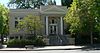 | May 8, 2007 (#07000405) | 1675 Montgomery St. 39°30′46″N 121°33′32″W / 39.512724°N 121.558904°W / 39.512724; -121.558904 (Oroville Carnegie Library) | Oroville | Now the Butte County Public Law Library[7] |
| 16 | Oroville Chinese Temple |  | July 30, 1976 (#76000478) | 1500 Broderick St. 39°30′49″N 121°33′39″W / 39.513611°N 121.560833°W / 39.513611; -121.560833 (Oroville Chinese Temple) | Oroville | |
| 17 | Oroville Commercial District (old) |  | July 28, 1983 (#83001174) | Montgomery, Myers, and Huntoon Sts. and Miner Alley 39°30′50″N 121°33′19″W / 39.513889°N 121.555278°W / 39.513889; -121.555278 (Oroville Commercial District (old)) | Oroville | |
| 18 | Oroville Inn |  | September 13, 1990 (#90001431) | 2066 Bird St. 39°30′49″N 121°33′16″W / 39.513641°N 121.55454°W / 39.513641; -121.55454 (Oroville Inn) | Oroville | |
| 19 | Patrick Ranch House |  | February 23, 1972 (#72000217) | 3 miles southeast of Chico off U.S. Route 99E 39°40′55″N 121°48′00″W / 39.681944°N 121.8°W / 39.681944; -121.8 (Patrick Ranch House) | Chico | |
| 20 | Patrick Rancheria | Upload image | February 23, 1972 (#72000218) | Address Restricted | Chico | |
| 21 | Silberstein Park Building |  | February 17, 1983 (#83001175) | 426, 430, and 434 Broadway 39°43′41″N 121°50′17″W / 39.728056°N 121.838056°W / 39.728056; -121.838056 (Silberstein Park Building) | Chico | Downtown building designed by A.J. Byron, and used as a movie theater, The Lyric, and La Grande Hotel. |
| 22 | South Campus Neighborhood | 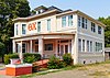 | June 24, 1991 (#91000636) | Bounded by W. 2nd, Normal, W. 6th, and Cherry Sts. 39°43′34″N 121°50′30″W / 39.726111°N 121.841667°W / 39.726111; -121.841667 (South Campus Neighborhood) | Chico | |
| 23 | Southern Pacific Depot |  | January 29, 1987 (#87000001) | 430 Orange St. 39°43′24″N 121°50′42″W / 39.723333°N 121.845°W / 39.723333; -121.845 (Southern Pacific Depot) | Chico | |
| 24 | St. John's Episcopal Church |  | January 21, 1982 (#82002171) | 230 Salem St. 39°43′44″N 121°50′25″W / 39.728889°N 121.840278°W / 39.728889; -121.840278 (St. John's Episcopal Church) | Chico | |
| 25 | Stansbury House | 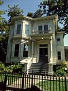 | June 5, 1975 (#75000424) | 307 W. 5th St. 39°43′37″N 121°50′19″W / 39.726944°N 121.838611°W / 39.726944; -121.838611 (Stansbury House) | Chico | |
| 26 | State Theatre |  | September 13, 1991 (#91001383) | 1489 Myers St. 39°30′45″N 121°33′16″W / 39.512592°N 121.554489°W / 39.512592; -121.554489 (State Theatre) | Oroville | |
| 27 | US Post Office-Chico Midtown Station |  | January 11, 1985 (#85000122) | 141 W. 5th St. 39°43′39″N 121°50′16″W / 39.7275°N 121.837778°W / 39.7275; -121.837778 (US Post Office-Chico Midtown Station) | Chico | |
| 28 | US Post Office-Oroville Main |  | January 11, 1985 (#85000123) | 1735 Robinson St. 39°30′40″N 121°33′27″W / 39.511174°N 121.55738°W / 39.511174; -121.55738 (US Post Office-Oroville Main) | Oroville |
See also
Wikimedia Commons has media related to National Register of Historic Places in Butte County, California.
- List of National Historic Landmarks in California
- National Register of Historic Places listings in California
- California Historical Landmarks in Butte County, California
References
- ^ The latitude and longitude information provided in this table was derived originally from the National Register Information System, which has been found to be fairly accurate for about 99% of listings. Some locations in this table may have been corrected to current GPS standards.
- ^ National Park Service, United States Department of the Interior, "National Register of Historic Places: Weekly List Actions", retrieved June 7, 2024.
- ^ Numbers represent an alphabetical ordering by significant words. Various colorings, defined here, differentiate National Historic Landmarks and historic districts from other NRHP buildings, structures, sites or objects.
- ^ "National Register Information System". National Register of Historic Places. National Park Service. July 9, 2010.
- ^ The eight-digit number below each date is the number assigned to each location in the National Register Information System database, which can be viewed by clicking the number.
- ^ http://www.orovillemr.com/news/ci_18659398 [dead link]
- ^ "Butte County Public Law Library". Retrieved 2014-08-22.
- v
- t
- e
- List of U.S. National Historic Landmarks by state:
- Alabama
- Alaska
- Arizona
- Arkansas
- California
- Colorado
- Connecticut
- Delaware
- Florida
- Georgia
- Hawaii
- Idaho
- Illinois
- Indiana
- Iowa
- Kansas
- Kentucky
- Louisiana
- Maine
- Maryland
- Massachusetts
- Michigan
- Minnesota
- Mississippi
- Missouri
- Montana
- Nebraska
- Nevada
- New Hampshire
- New Jersey
- New Mexico
- New York
- North Carolina
- North Dakota
- Ohio
- Oklahoma
- Oregon
- Pennsylvania
- Rhode Island
- South Carolina
- South Dakota
- Tennessee
- Texas
- Utah
- Vermont
- Virginia
- Washington
- West Virginia
- Wisconsin
- Wyoming
 National Register of Historic Places portal
 Category


Municipalities and communities of Butte County, California, United States | ||
|---|---|---|
County seat: Oroville | ||
| Cities and towns |  | |
| CDPs | ||
| Unincorporated communities | ||
| Ghost towns | ||
| Footnotes | ‡This populated place also has portions in an adjacent county or counties | |
| ||


