National Register of Historic Places listings in Teton County, Wyoming

This is a list of the National Register of Historic Places listings in Teton County, Wyoming.
This is intended to be a complete list of the properties and districts on the National Register of Historic Places in Teton County, Wyoming, United States.
There are 62 properties and districts listed on the National Register in the county, 5 of which are National Historic Landmarks. Another property was once listed on the Register but has been removed.
This National Park Service list is complete through NPS recent listings posted May 24, 2024.[1]
Map all coordinates using OpenStreetMap
Download coordinates as:
- KML
- GPX (all coordinates)
- GPX (primary coordinates)
- GPX (secondary coordinates)
| Albany - Big Horn - Campbell - Carbon - Converse - Crook - Fremont - Goshen - Hot Springs - Johnson - Laramie - Lincoln - Natrona - Niobrara - Park - Platte - Sheridan - Sublette - Sweetwater - Teton - Uinta - Washakie - Weston |
Current listings
| [2] | Name on the Register | Image | Date listed[3] | Location | City or town | Description |
|---|---|---|---|---|---|---|
| 1 | 4 Lazy F Dude Ranch | 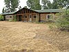 | April 23, 1990 (#90000611) | Off Teton Park Rd. 43°40′03″N 110°42′27″W / 43.6675°N 110.7075°W / 43.6675; -110.7075 (4 Lazy F Dude Ranch) | Moose | |
| 2 | AMK Ranch |  | April 23, 1990 (#90000615) | Off U.S. Routes 27/89 43°56′20″N 110°38′30″W / 43.9389°N 110.6417°W / 43.9389; -110.6417 (AMK Ranch) | Moran | |
| 3 | Alpenhof Lodge |  | August 9, 2016 (#16000520) | 3255 W. Village Dr. 43°35′16″N 110°49′34″W / 43.5879°N 110.8261°W / 43.5879; -110.8261 (Alpenhof Lodge) | Teton Village | |
| 4 | Bar B C Dude Ranch | 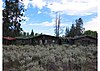 | April 23, 1990 (#90000624) | Off Teton Park Rd. 43°41′42″N 110°41′42″W / 43.695°N 110.695°W / 43.695; -110.695 (Bar B C Dude Ranch) | Moose | |
| 5 | Bridge over Snake River-Structure DEY |  | August 1, 2022 (#100007949) | County Road 11, 7.5 mi. south of Jackson 43°22′18″N 110°44′21″W / 43.371797°N 110.739138°W / 43.371797; -110.739138 (Bridge over Snake River-Structure DEY) | Jackson | Removed in late 2023[4] |
| 6 | The Brinkerhoff |  | April 23, 1990 (#90000622) | Teton Park Rd. 43°51′03″N 110°35′35″W / 43.8508°N 110.5931°W / 43.8508; -110.5931 (The Brinkerhoff) | Moose | |
| 7 | Cascade Canyon Barn |  | August 18, 1998 (#98001023) | Cascade Canyon 5 miles upstream from Jenny Lake 43°46′05″N 110°49′22″W / 43.7681°N 110.8228°W / 43.7681; -110.8228 (Cascade Canyon Barn) | Moose | |
| 8 | Andy Chambers Ranch Historic District |  | April 23, 1990 (#90000623) | Mormon Row east of Moose 43°39′29″N 110°39′41″W / 43.6581°N 110.6614°W / 43.6581; -110.6614 (Andy Chambers Ranch Historic District) | Moose | |
| 9 | Chapel of the Transfiguration |  | April 10, 1980 (#80004055) | Grand Teton National Park 43°39′37″N 110°42′52″W / 43.6603°N 110.7144°W / 43.6603; -110.7144 (Chapel of the Transfiguration) | Moose | |
| 10 | Cunningham Cabin |  | October 2, 1973 (#73000225) | Northeast of Moose off U.S. Routes 26/89/187 in Grand Teton National Park 43°46′44″N 110°33′28″W / 43.7789°N 110.5578°W / 43.7789; -110.5578 (Cunningham Cabin) | Moose | |
| 11 | Darwin Ranch | Upload image | April 27, 2021 (#100005445) | 1 Kinky Creek Rd. 43°24′44″N 110°09′41″W / 43.4123°N 110.1613°W / 43.4123; -110.1613 (Darwin Ranch) | Cora vicinity | |
| 12 | Death Canyon Barn | 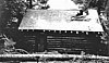 | August 25, 1998 (#98001024) | 5 miles northwest of Phelps Lake near Alaska Basin 43°39′53″N 110°49′45″W / 43.6647°N 110.8292°W / 43.6647; -110.8292 (Death Canyon Barn) | Moose | |
| 13 | Double Diamond Dude Ranch Dining Hall |  | August 18, 1998 (#98001028) | 5 miles north of Moose, western side of Teton Park Rd. and Cottonwood Creek 43°42′07″N 110°44′05″W / 43.7019°N 110.7347°W / 43.7019; -110.7347 (Double Diamond Dude Ranch Dining Hall) | Moose | |
| 14 | Flat Creek Ranch | Upload image | December 31, 2001 (#01001428) | Approximately 12 miles east and north 43°31′40″N 110°32′33″W / 43.5278°N 110.5425°W / 43.5278; -110.5425 (Flat Creek Ranch) | Jackson | |
| 15 | Game Creek | Upload image | December 2, 2019 (#100004708) | Address Restricted | Jackson vicinity | |
| 16 | Gap Puche Cabin | Upload image | June 18, 1990 (#90000889) | Gros Ventre R. Rd. east of Grizzly Lake 43°36′32″N 110°27′15″W / 43.6089°N 110.4542°W / 43.6089; -110.4542 (Gap Puche Cabin) | Jackson | |
| 17 | George Washington Memorial Park |  | December 5, 2003 (#03001250) | Between Cache, Center, Broadway, and Deloney 43°28′48″N 110°45′42″W / 43.480°N 110.7617°W / 43.480; -110.7617 (George Washington Memorial Park) | Jackson | |
| 18 | Hardeman Barns | 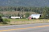 | April 28, 2015 (#15000190) | 5450 W. WY 22 43°29′52″N 110°52′12″W / 43.4978°N 110.8699°W / 43.4978; -110.8699 (Hardeman Barns) | Wilson | |
| 19 | Highlands Historic District |  | August 19, 1998 (#98001029) | 5 miles north of park headquarters, ¼ mile west of Teton Park Rd. 43°42′32″N 110°43′45″W / 43.7089°N 110.7292°W / 43.7089; -110.7292 (Highlands Historic District) | Moose | |
| 20 | Huckleberry Mountain Fire Lookout | Upload image | July 8, 1983 (#83003365) | Off U.S. Routes 89/287 44°04′57″N 110°35′50″W / 44.0825°N 110.5972°W / 44.0825; -110.5972 (Huckleberry Mountain Fire Lookout) | Teton National Forest | |
| 21 | Huff Memorial Library |  | December 5, 2003 (#03001253) | 320 S. King St. 43°28′41″N 110°45′37″W / 43.4781°N 110.7603°W / 43.4781; -110.7603 (Huff Memorial Library) | Jackson | |
| 22 | Hunter Hereford Ranch Historic District |  | August 24, 1998 (#98001031) | Southeastern corner of park, south of Shadow Mountain along Aspen Ridge 43°40′33″N 110°36′36″W / 43.6759°N 110.6099°W / 43.6759; -110.6099 (Hunter Hereford Ranch Historic District) | Moose | |
| 23 | Jackson Hole American Legion Post No. 43 | 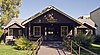 | September 12, 2003 (#03000939) | 182 N. Cache 43°28′55″N 110°45′40″W / 43.4819°N 110.7611°W / 43.4819; -110.7611 (Jackson Hole American Legion Post No. 43) | Jackson | |
| 24 | Jackson Lake Lodge | 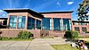 | July 31, 2003 (#03001039) | Teton Park Road 43°52′50″N 110°34′32″W / 43.880556°N 110.575556°W / 43.880556; -110.575556 (Jackson Lake Lodge) | Moran | |
| 25 | Jackson Lake Ranger Station |  | April 23, 1990 (#90000620) | Off Teton Park Rd. 43°52′18″N 110°34′14″W / 43.871667°N 110.570556°W / 43.871667; -110.570556 (Jackson Lake Ranger Station) | Moose | |
| 26 | Jenny Lake Boat Concession Facilities |  | August 24, 1998 (#98001032) | Southern end of Jenny Lake 43°45′04″N 110°43′31″W / 43.751111°N 110.725278°W / 43.751111; -110.725278 (Jenny Lake Boat Concession Facilities) | Moose | |
| 27 | Jenny Lake CCC Camp NP-4 | 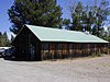 | July 7, 2006 (#98001033) | ¼ mile south of Jenny Lake on the western side of Cottonwood Creek 43°44′58″N 110°43′28″W / 43.749444°N 110.724444°W / 43.749444; -110.724444 (Jenny Lake CCC Camp NP-4) | Moose | |
| 28 | Jenny Lake Ranger Station Historic District |  | April 23, 1990 (#90000610) | Jenny Lake Rd. 43°45′13″N 110°43′19″W / 43.753611°N 110.721944°W / 43.753611; -110.721944 (Jenny Lake Ranger Station Historic District) | Moose | |
| 29 | Kimmel Kabins |  | April 23, 1990 (#90000612) | Off Teton Park Rd. 43°44′38″N 110°43′38″W / 43.743889°N 110.727222°W / 43.743889; -110.727222 (Kimmel Kabins) | Moose | |
| 30 | Lake Fish Hatchery Historic District | 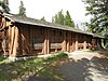 | December 7, 1982 (#85001416) | Yellowstone National Park 44°32′58″N 110°24′13″W / 44.549444°N 110.403611°W / 44.549444; -110.403611 (Lake Fish Hatchery Historic District) | Canyon Village | |
| 31 | Lake Hotel |  | May 16, 1991 (#91000637) | Northwestern shore of Lake Yellowstone 44°32′59″N 110°24′00″W / 44.549722°N 110.4°W / 44.549722; -110.4 (Lake Hotel) | Yellowstone National Park | |
| 32 | Leigh Lake Ranger Patrol Cabin |  | April 23, 1990 (#90000618) | Off Teton Park Teton Rd. at Lehigh Lake 43°49′36″N 110°44′16″W / 43.826667°N 110.737778°W / 43.826667; -110.737778 (Leigh Lake Ranger Patrol Cabin) | Moose | |
| 33 | Geraldine Lucas Homestead-Fabian Place Historic District |  | August 24, 1998 (#98001034) | 4.5 miles north of Moose 43°43′16″N 110°44′03″W / 43.721111°N 110.734167°W / 43.721111; -110.734167 (Geraldine Lucas Homestead-Fabian Place Historic District) | Moose | |
| 34 | Madison Museum |  | July 9, 1982 (#82001720) | Yellowstone National Park 44°38′32″N 110°51′41″W / 44.642222°N 110.861389°W / 44.642222; -110.861389 (Madison Museum) | Madison Junction | |
| 35 | Manges Cabin |  | August 19, 1998 (#98001035) | Southern end of park southeast of Taggart Lake 43°41′54″N 110°43′59″W / 43.698333°N 110.733056°W / 43.698333; -110.733056 (Manges Cabin) | Moose | |
| 36 | Menor's Ferry |  | April 16, 1969 (#69000016) | Across the Snake River just above park headquarters, Grand Teton National Park 43°39′30″N 110°42′29″W / 43.658333°N 110.708056°W / 43.658333; -110.708056 (Menor's Ferry) | Moose | |
| 37 | Miller Cabin |  | April 16, 1969 (#69000195) | 1 mile northeast of Jackson 43°29′20″N 110°44′16″W / 43.488889°N 110.737778°W / 43.488889; -110.737778 (Miller Cabin) | Jackson | |
| 38 | Grace and Robert Miller Ranch | | November 11, 2002 (#01001454) | 1 mile northeast of Jackson 43°29′22″N 110°44′12″W / 43.489444°N 110.736667°W / 43.489444; -110.736667 (Grace and Robert Miller Ranch) | Jackson | |
| 39 | Moose Entrance Kiosk |  | April 23, 1990 (#90000619) | Teton Park Rd. 43°39′30″N 110°43′09″W / 43.658333°N 110.719167°W / 43.658333; -110.719167 (Moose Entrance Kiosk) | Moose | |
| 40 | Moran Bay Patrol Cabin | Upload image | August 25, 1998 (#98001037) | Northern bank of Moran Bay on Jackson Lake 43°39′53″N 110°49′45″W / 43.664722°N 110.829167°W / 43.664722; -110.829167 (Moran Bay Patrol Cabin) | Moose | Destroyed by forest fire in 2000[5] |
| 41 | Mormon Row Historic District | 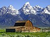 | June 5, 1997 (#97000495) | Roughly east of U.S. Routes 26/89/187 from Antelope Flats to Grand Teton National Park-Teton National Forest border 43°39′24″N 110°37′06″W / 43.656667°N 110.618333°W / 43.656667; -110.618333 (Mormon Row Historic District) | Moose | |
| 42 | Murie Ranch Historic District |  | August 24, 1998 (#98001039) | ½ mile southwest of park headquarters 43°39′02″N 110°43′37″W / 43.650556°N 110.726944°W / 43.650556; -110.726944 (Murie Ranch Historic District) | Moose | |
| 43 | Murie Residence |  | April 23, 1990 (#90000616) | Off Moose Wilson Rd. 43°39′00″N 110°43′37″W / 43.65°N 110.726944°W / 43.65; -110.726944 (Murie Residence) | Moose | |
| 44 | Norris, Madison, and Fishing Bridge Museums |  | May 28, 1987 (#87001445) | Norris Geyser Basin, Madison Junction, and Fishing Bridge 44°38′38″N 110°38′49″W / 44.643889°N 110.646944°W / 44.643889; -110.646944 (Norris, Madison, and Fishing Bridge Museums) | Yellowstone National Park | |
| 45 | Old Administrative Area Historic District |  | April 23, 1990 (#90000621) | Off Teton Park Rd. 43°41′10″N 110°44′08″W / 43.686111°N 110.735556°W / 43.686111; -110.735556 (Old Administrative Area Historic District) | Moose | |
| 46 | Old Faithful Historic District |  | December 7, 1982 (#82001839) | Both sides of Grand Loop Rd. at Old Faithful Geyser 44°27′13″N 110°50′09″W / 44.453611°N 110.835833°W / 44.453611; -110.835833 (Old Faithful Historic District) | Yellowstone National Park | |
| 47 | Old Faithful Inn |  | July 23, 1973 (#73000226) | West of West Thumb at Old Faithful Geyser on Grand Loop Rd. 44°27′35″N 110°49′49″W / 44.459722°N 110.830278°W / 44.459722; -110.830278 (Old Faithful Inn) | West Thumb | |
| 48 | Queen's Laundry Bath House |  | July 25, 2001 (#01000790) | Sentinel Meadows, Lower Geyser Basin 44°33′50″N 110°52′11″W / 44.563889°N 110.869722°W / 44.563889; -110.869722 (Queen's Laundry Bath House) | Yellowstone National Park | |
| 49 | Ramshorn Dude Ranch Lodge |  | August 19, 1998 (#98001041) | Southeastern corner of park, 2.5 miles northwest of Kelly 43°40′11″N 110°35′46″W / 43.669722°N 110.596111°W / 43.669722; -110.596111 (Ramshorn Dude Ranch Lodge) | Moose | |
| 50 | Rosencrans Cabin Historic District | Upload image | August 6, 1980 (#80004056) | 9 miles east of Moran 43°50′00″N 110°20′44″W / 43.833333°N 110.345556°W / 43.833333; -110.345556 (Rosencrans Cabin Historic District) | Moran | |
| 51 | Snake River Land Company Residence and Office | 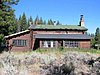 | July 7, 2006 (#98001036) | Western bank of the Snake River, ¼ north of Moran Junction 43°50′33″N 110°30′44″W / 43.8425°N 110.512222°W / 43.8425; -110.512222 (Snake River Land Company Residence and Office) | Moose | |
| 52 | Snake River Ranch | Upload image | November 26, 2004 (#04001089) | 5700 Snake River Ranch Rd. 43°33′42″N 110°47′59″W / 43.561667°N 110.799722°W / 43.561667; -110.799722 (Snake River Ranch) | Wilson | |
| 53 | Squirrel Meadows Guard Station | Upload image | October 4, 1990 (#90000149) | Forest Rd. 20031 44°03′48″N 111°01′14″W / 44.063333°N 111.020556°W / 44.063333; -111.020556 (Squirrel Meadows Guard Station) | City unavailable | |
| 54 | St. John's Episcopal Church and Rectory |  | December 1, 1978 (#78002834) | 132 N. Glenwood 43°28′54″N 110°45′50″W / 43.481667°N 110.763889°W / 43.481667; -110.763889 (St. John's Episcopal Church and Rectory) | Jackson | |
| 55 | String Lake Comfort Station |  | April 23, 1990 (#90000617) | Off Teton Park Rd. at String Lake 43°47′19″N 110°43′47″W / 43.788611°N 110.729722°W / 43.788611; -110.729722 (String Lake Comfort Station) | Moose | |
| 56 | Triangle X Barn |  | August 19, 1998 (#98001042) | Eastern side of park, north of Shadow Mountain 43°45′53″N 110°34′01″W / 43.764722°N 110.566944°W / 43.764722; -110.566944 (Triangle X Barn) | Moose | |
| 57 | Upper Granite Canyon Patrol Cabin |  | August 19, 1998 (#98001043) | Southwestern corner of park at Granite Canyon, Rendezvous Pass 43°36′49″N 110°53′50″W / 43.613611°N 110.897222°W / 43.613611; -110.897222 (Upper Granite Canyon Patrol Cabin) | Moose | |
| 58 | Van Vleck House and Barn | 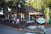 | September 7, 1995 (#95001075) | 135 E. Broadway 43°28′50″N 110°45′34″W / 43.480556°N 110.759444°W / 43.480556; -110.759444 (Van Vleck House and Barn) | Jackson | |
| 59 | Henry and Estella Weston House |  | January 3, 2023 (#100008513) | 165 East Broadway 43°28′47″N 110°45′34″W / 43.4796°N 110.7595°W / 43.4796; -110.7595 (Henry and Estella Weston House) | Jackson | |
| 60 | White Grass Dude Ranch |  | April 23, 1990 (#90000613) | Off Moose Wilson Rd. 43°39′28″N 110°46′23″W / 43.657778°N 110.773056°W / 43.657778; -110.773056 (White Grass Dude Ranch) | Moose | |
| 61 | White Grass Ranger Station Historic District |  | April 23, 1990 (#90000614) | Off Moose Wilson Rd. 43°39′20″N 110°46′48″W / 43.655556°N 110.78°W / 43.655556; -110.78 (White Grass Ranger Station Historic District) | Moose | |
| 62 | Wort Hotel |  | December 9, 1999 (#99001507) | 50 N. Glenwood St. 43°28′48″N 110°45′45″W / 43.48°N 110.7625°W / 43.48; -110.7625 (Wort Hotel) | Jackson |
Former listings
| [2] | Name on the Register | Image | Date listed | Date removed | Location | City or town | Description |
|---|---|---|---|---|---|---|---|
| 1 | Leek's Lodge |  | September 5, 1975 (#75000216) | April 15, 2014 | 10 miles northwest of Moran in Grand Teton National Park off U.S. Routes 89/287 43°55′50″N 110°38′20″W / 43.930556°N 110.638889°W / 43.930556; -110.638889 (Leek's Lodge) | Moran | Destroyed by fire in 1998.[6] |
See also
Wikimedia Commons has media related to National Register of Historic Places in Teton County, Wyoming.
- List of National Historic Landmarks in Wyoming
- National Register of Historic Places listings in Wyoming
References
- ^ National Park Service, United States Department of the Interior, "National Register of Historic Places: Weekly List Actions", retrieved May 24, 2024.
- ^ a b Numbers represent an alphabetical ordering by significant words. Various colorings, defined here, differentiate National Historic Landmarks and historic districts from other NRHP buildings, structures, sites or objects.
- ^ The eight-digit number below each date is the number assigned to each location in the National Register Information System database, which can be viewed by clicking the number.
- ^ [1]
- ^ https://jpritch.public.iastate.edu/homepage_files/GTNP%20Cabin%20Report%20AMK%20Ann.htm [dead link]
- ^ "Leek's Lodge Chimney". List of Classified Structures. National Park Service. Archived from the original on 1 June 2012. Retrieved 19 November 2009.
- v
- t
- e
- List of U.S. National Historic Landmarks by state:
- Alabama
- Alaska
- Arizona
- Arkansas
- California
- Colorado
- Connecticut
- Delaware
- Florida
- Georgia
- Hawaii
- Idaho
- Illinois
- Indiana
- Iowa
- Kansas
- Kentucky
- Louisiana
- Maine
- Maryland
- Massachusetts
- Michigan
- Minnesota
- Mississippi
- Missouri
- Montana
- Nebraska
- Nevada
- New Hampshire
- New Jersey
- New Mexico
- New York
- North Carolina
- North Dakota
- Ohio
- Oklahoma
- Oregon
- Pennsylvania
- Rhode Island
- South Carolina
- South Dakota
- Tennessee
- Texas
- Utah
- Vermont
- Virginia
- Washington
- West Virginia
- Wisconsin
- Wyoming
 National Register of Historic Places portal
 Category


Municipalities and communities of Teton County, Wyoming, United States | ||
|---|---|---|
County seat: Jackson | ||
| Town | 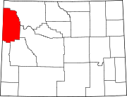 | |
| CDPs | ||
| Unincorporated communities | ||
| ||


