Oberweißbacher Bergbahn
Railway line in Thuringia, Germany
You can help expand this article with text translated from the corresponding article in German. (December 2015) Click [show] for important translation instructions.
- View a machine-translated version of the German article.
- Machine translation, like DeepL or Google Translate, is a useful starting point for translations, but translators must revise errors as necessary and confirm that the translation is accurate, rather than simply copy-pasting machine-translated text into the English Wikipedia.
- Consider adding a topic to this template: there are already 9,154 articles in the main category, and specifying
|topic=will aid in categorization. - Do not translate text that appears unreliable or low-quality. If possible, verify the text with references provided in the foreign-language article.
- You must provide copyright attribution in the edit summary accompanying your translation by providing an interlanguage link to the source of your translation. A model attribution edit summary is
Content in this edit is translated from the existing German Wikipedia article at [[:de:Oberweißbacher Bergbahn]]; see its history for attribution. - You may also add the template
{{Translated|de|Oberweißbacher Bergbahn}}to the talk page. - For more guidance, see Wikipedia:Translation.
5.75 km/h (3.57 mph) max. (funicular section).
Route map | ||||||||||||||||||||||||||||||||||||||||||||||||||||||||||||||||||||||||||||||||||||||||||||||||||||||||||||||||||||||||||||||||
|---|---|---|---|---|---|---|---|---|---|---|---|---|---|---|---|---|---|---|---|---|---|---|---|---|---|---|---|---|---|---|---|---|---|---|---|---|---|---|---|---|---|---|---|---|---|---|---|---|---|---|---|---|---|---|---|---|---|---|---|---|---|---|---|---|---|---|---|---|---|---|---|---|---|---|---|---|---|---|---|---|---|---|---|---|---|---|---|---|---|---|---|---|---|---|---|---|---|---|---|---|---|---|---|---|---|---|---|---|---|---|---|---|---|---|---|---|---|---|---|---|---|---|---|---|---|---|---|---|
|
| ||||||||||||||||||||||||||||||||||||||||||||||||||||||||||||||||||||||||||||||||||||||||||||||||||||||||||||||||||||||||||||||||


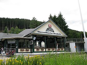
The Oberweißbacher Bergbahn is a German railway in the Thuringian Highland, Thuringia. Since 1922 it connects Obstfelderschmiede (Mellenbach-Glasbach) with the village Lichtenhain, Oberweißbach and Cursdorf. The train consists of 1.351 km broad gauge cable railway and connects to a 2.635 km standard gauge electrified adhesion railway.[2]
History
Both railways are operationally closely linked. Since January 1982 the Oberweissbacher-Bergbahn is a historical monument.[3] The railway is operated by Deutsche Bahn AG and offers about thirty rides every half-hour from 5:30 am to 8:00 pm.
Operation
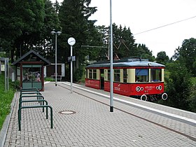
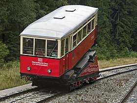
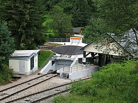
This funicular is unusual because instead of using two purpose-built passenger vehicles, it only features one. The other vehicle is a flat wagon that is designed to carry a single standard gauge passenger car, freight wagon or locomotive between the conventional railway systems at the bottom and the top. At the top, both vehicles pull into a passenger halt at Lichtenhain/Bergbahn, but the standard gauge track on the flat wagon can interface with the standard gauge railway.
At the bottom, there is a turnout that sends the two vehicles into separate termini. The passenger vehicle is directed into a conventional funicular passenger halt, but the flat wagon is directed to interface with a turntable on the Schwartzatalbahn adjacent to Obstfelderschmiede station. In normal day-to-day passenger service, the flatbed vehicle is loaded with a dedicated passenger car carrying the Oberweißbacher Bergbahn branding. Passenger access to this car is provided at the terminus.[4]
|


References
- ^ DB leaflet Bahnfahren und Wandern im Schwartzatal (in German though the gradient reads the same)
- ^ "Oberweißbacher Berg- und Schwarzatalbahn". www.oberweissbacher-bergbahn.com. Retrieved 2015-11-22.
- ^ "Technical Sheet (German)" (PDF). Archived from the original (PDF) on 2015-11-23.
- ^ Publication: Bergbahn-Zeiten-eine Reise in Bildern (in German) ISBN 3-935961-03-0
External links
Wikimedia Commons has media related to Oberweißbacher Bergbahn.
- Oberweißbacher Bergbahn official website
- Oberweißbacher Bergbahn on the DB-Schwarzatalbahn website
- Lichtenhainer Waldeisenbahn
Authority control databases | |
|---|---|
| International |
|
| National |
|
50°35′55″N 11°07′50″E / 50.5986°N 11.1306°E / 50.5986; 11.1306
- v
- t
- e


