Ondo West
LGA in Ondo State, Nigeria
Ondo West | |
|---|---|
| Country |  Nigeria Nigeria |
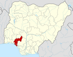
| State | Ondo State |
| Government | |
| • Body | Osemawe-in-Council |
| • Oba | Osemawe of Ondo Kingdom |
| Area | |
| • Total | 370 sq mi (970 km2) |
| Population (2006) | |
| • Total | 283,672 |
| Time zone | UTC+1 (WAT) |
 | |
Ondo West is a Local Government Area in Ondo State, Nigeria. Its headquarters are in the town of Ondo.[1]
It has an area of 970 km2 and a population of 283,672 at the 2006 census.
The postal code of the area is 351.[2]
There are four higher institutions in Ondo West: Adeyemi College of Education established in 1964 by the Federal Government of Nigeria and recently upgraded to a Federal University of Education; National Institute for Educational Planning and Administration (NIEPA) established in 1992 by the Federal Government; Wesley University established in 2008 by the Methodist Church, Nigeria; and the University of Medical Sciences, Ondo established by the Ondo State Government in 2015 to train medical and health professionals.
References
- v
- t
- e
Ondo StateState capital: Akure
- Akoko North-East
- Akoko North-West
- Akoko South-East
- Akoko South-West
- Akure North
- Akure South
- Ese Odo
- Idanre
- Ifedore
- Ilaje
- Ile Oluji/Okeigbo
- Irele
- Odigbo
- Oka
- Okitipupa
- Ondo East
- Ondo West
- Ose
- Owo
 | This Ondo State, Nigeria location article is a stub. You can help Wikipedia by expanding it. |
- v
- t
- e


