Orocué
Municipality and town in Orinoquía Region, Colombia

Flag
San Miguel del Macuco, Caño San Miguel
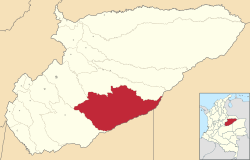
Location of the municipality and town of Orocue in the Casanare Department of Colombia
 Colombia
 (2012)
Orocué is a town and municipality in the Department of Casanare, Colombia, located on the shore of the Meta River. Historically, it went by the name San Miguel del Macuco.[3]
It is located 180 km from Yopal, and 546 km from Bogotá.[4]
Climate
Orocué has a tropical savanna climate (Köppen Aw) with moderate to little rainfall from December to March and heavy rainfall from April to November.
| Climate data for Orocué (Modulos), elevation 130 m (430 ft), (1981–2010) | |||||||||||||
|---|---|---|---|---|---|---|---|---|---|---|---|---|---|
| Month | Jan | Feb | Mar | Apr | May | Jun | Jul | Aug | Sep | Oct | Nov | Dec | Year |
| Mean daily maximum °C (°F) | 33.1 (91.6) | 34.1 (93.4) | 34.1 (93.4) | 32.4 (90.3) | 31.3 (88.3) | 30.3 (86.5) | 30.2 (86.4) | 30.8 (87.4) | 31.7 (89.1) | 31.9 (89.4) | 32.0 (89.6) | 32.0 (89.6) | 32.0 (89.6) |
| Daily mean °C (°F) | 27.4 (81.3) | 28.2 (82.8) | 28.2 (82.8) | 26.9 (80.4) | 26.2 (79.2) | 25.6 (78.1) | 25.5 (77.9) | 25.9 (78.6) | 26.5 (79.7) | 26.7 (80.1) | 26.9 (80.4) | 27.0 (80.6) | 26.7 (80.1) |
| Mean daily minimum °C (°F) | 20.6 (69.1) | 20.9 (69.6) | 21.5 (70.7) | 21.8 (71.2) | 22.0 (71.6) | 22.0 (71.6) | 21.7 (71.1) | 21.8 (71.2) | 21.9 (71.4) | 22.2 (72.0) | 22.5 (72.5) | 21.7 (71.1) | 21.7 (71.1) |
| Average precipitation mm (inches) | 16.4 (0.65) | 38.2 (1.50) | 81.9 (3.22) | 228.0 (8.98) | 322.7 (12.70) | 385.1 (15.16) | 309.1 (12.17) | 281.5 (11.08) | 225.8 (8.89) | 217.9 (8.58) | 158.5 (6.24) | 39.7 (1.56) | 2,304.8 (90.74) |
| Average precipitation days | 2 | 5 | 7 | 15 | 21 | 21 | 21 | 19 | 16 | 15 | 10 | 4 | 152 |
| Average relative humidity (%) | 72 | 71 | 71 | 80 | 85 | 86 | 85 | 85 | 83 | 82 | 81 | 77 | 80 |
| Mean monthly sunshine hours | 254.2 | 197.6 | 161.2 | 135.0 | 130.2 | 123.0 | 130.2 | 139.5 | 156.0 | 170.5 | 183.0 | 238.7 | 2,019.1 |
| Mean daily sunshine hours | 8.2 | 7.0 | 5.2 | 4.5 | 4.2 | 4.1 | 4.2 | 4.5 | 5.2 | 5.5 | 6.1 | 7.7 | 5.5 |
| Source: Instituto de Hidrologia Meteorologia y Estudios Ambientales[5] | |||||||||||||
See also
References
- ^ Municipio de Orocué
- ^ "Orocue Map". Colombia Google Satellite Maps. Retrieved 2014-05-24.
- ^ "A Study of the Saliba Language". World Digital Library. Retrieved 24 April 2013.
- ^ Municipio de Orocué
- ^ "Promedios Climatológicos 1981–2010" (in Spanish). Instituto de Hidrologia Meteorologia y Estudios Ambientales. Archived from the original on 15 August 2016. Retrieved 17 June 2024.
External links
- Municipio de Orocué - Official website

Authority control databases | |
|---|---|
| International |
|
| National |
|
4°47′39″N 71°20′24″W / 4.79417°N 71.34°W / 4.79417; -71.34
 | This Department of Casanare location article is a stub. You can help Wikipedia by expanding it. |
- v
- t
- e


