Philadelphia and Reading Railroad, Schuylkill River Viaduct
Bridge in Fairmount Park
40°00′23″N 75°11′34″W / 40.00639°N 75.19278°W / 40.00639; -75.19278
The Philadelphia and Reading Railroad, Schuylkill River Viaduct, also called the Reading Railroad Bridge and the Falls Rail Bridge, is a stone arch bridge that carries rail traffic over the Schuylkill River at Falls of Schuylkill (East Falls) in Philadelphia, Pennsylvania. Located in Fairmount Park, the bridge also spans Martin Luther King, Jr., Drive, and Kelly Drive. The name Philadelphia & Reading Railroad (P&R) was later shortened to Reading Company.
The current bridge replaced an adjacent P&R bridge, built of wood. Prior to that, one of the earliest suspension bridges in the United States, the 1808 Chain Bridge at Falls of Schuylkill (collapsed 1816), was built at this location. That was replaced by an 1818 covered bridge, built on the chain bridge's abutments, which washed away in 1822.[1]
The P&R built the viaduct, 1853–56, to carry coal cars to the company's coal terminal on the Delaware River in the Port Richmond neighborhood of Philadelphia.
The bridge's design is unusual. Because it crosses the river at an oblique angle, it was constructed as a ribbed skew arch bridge, with each span composed of a series of offset stone arches. While not as strong as skewed barrel vault spans, these spans were much easier to build, while still assuring that the bridge's abutments were parallel to the water flow.
The bridge consists of six main spans, each 78 feet (24 m) in length, crossing the river and Kelly Drive; five small arches, each 9 feet (2.7 m) in length, for pedestrian traffic; and a 30-foot (9.1 m) arch over Martin Luther King, Jr., Drive. The bridge's spandrel walls were reinforced in 1935. The bridge continues to carry rail traffic to this day.
Gallery
-
 Philadelphia & Reading Railroad, Schuylkill River Viaduct.
 -
 1872 map of Schuylkill River showing the Reading Railroad Bridge.
 -
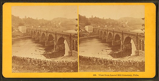 "View from Laurel Hill Cemetery, Phila." (before 1895). Reading Railroad Bridge, with former Falls Covered Bridge in the distance.
 -
!["Falls Station Bridge leading to [Port] Richmond, near Philadelphia." Laurel Hill Cemetery is visible in the upper right.](//upload.wikimedia.org/wikipedia/commons/thumb/4/4b/Falls_Station_bridge_leading_to_Richmond%2C_near_Philadelphia%2C_from_Robert_N._Dennis_collection_of_stereoscopic_views.jpg/533px-Falls_Station_bridge_leading_to_Richmond%2C_near_Philadelphia%2C_from_Robert_N._Dennis_collection_of_stereoscopic_views.jpg) "Falls Station Bridge leading to [Port] Richmond, near Philadelphia." Laurel Hill Cemetery is visible in the upper right.
"Falls Station Bridge leading to [Port] Richmond, near Philadelphia." Laurel Hill Cemetery is visible in the upper right.


!["Falls Station Bridge leading to [Port] Richmond, near Philadelphia." Laurel Hill Cemetery is visible in the upper right.](http://upload.wikimedia.org/wikipedia/commons/thumb/4/4b/Falls_Station_bridge_leading_to_Richmond%2C_near_Philadelphia%2C_from_Robert_N._Dennis_collection_of_stereoscopic_views.jpg/533px-Falls_Station_bridge_leading_to_Richmond%2C_near_Philadelphia%2C_from_Robert_N._Dennis_collection_of_stereoscopic_views.jpg)
See also
 Philadelphia portal

- List of bridges documented by the Historic American Engineering Record in Pennsylvania
- List of crossings of the Schuylkill River
- Chain Bridge at Falls of Schuylkill
Notes
- ^ Jackson, Joseph (1931). Encyclopedia of Philadelphia. Vol. 2. Harrisburg: National Historical Association, Inc. pp. 411–412.
References
- "Philadelphia and Reading Railroad Bridge". Gleason's Pictorial Drawing Room Companion. 1 (3): 48. May 17, 1851.
- Steele, J. Dutton (1870). "On Skew Bridges, and on the Construction of Falls Skew Bridge over the Schuylkill, near Philadelphia". Transactions of the American Society of Civil Engineers. 1: 209–213.
External links
- Historic American Engineering Record (HAER) No. PA-39, "Philadelphia & Reading Railroad, Schuylkill River Viaduct"
- Listing at Philadelphia Architects and Buildings
Crossings of the Schuylkill River | ||||
|---|---|---|---|---|
| ||||


