Pila-Canale
Commune in Corsica, France
You can help expand this article with text translated from the corresponding article in French. (January 2009) Click [show] for important translation instructions.
- View a machine-translated version of the French article.
- Machine translation, like DeepL or Google Translate, is a useful starting point for translations, but translators must revise errors as necessary and confirm that the translation is accurate, rather than simply copy-pasting machine-translated text into the English Wikipedia.
- Do not translate text that appears unreliable or low-quality. If possible, verify the text with references provided in the foreign-language article.
- You must provide copyright attribution in the edit summary accompanying your translation by providing an interlanguage link to the source of your translation. A model attribution edit summary is
Content in this edit is translated from the existing French Wikipedia article at [[:fr:Pila-Canale]]; see its history for attribution. - You may also add the template
{{Translated|fr|Pila-Canale}}to the talk page. - For more guidance, see Wikipedia:Translation.
Commune in Corsica, France
Pila-Canale | ||
|---|---|---|
Commune | ||
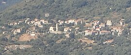 A general view of Pila-Canale | ||
Location of Pila-Canale  | ||
(2020–2026) Emmanuel Guglielmi[1] | | |
| Area 1 | 18.8 km2 (7.3 sq mi) | |
| Population (2021)[2] | 277 | |
| • Density | 15/km2 (38/sq mi) | |
| Time zone | UTC+01:00 (CET) | |
| • Summer (DST) | UTC+02:00 (CEST) | |
| INSEE/Postal code | 2A232 /20123 | |
| Elevation | 13–561 m (43–1,841 ft) (avg. 350 m or 1,150 ft) | |
| 1 French Land Register data, which excludes lakes, ponds, glaciers > 1 km2 (0.386 sq mi or 247 acres) and river estuaries. | ||
Pila-Canale is a commune in the Corse-du-Sud department of France on the island of Corsica.

Geography
Climate
Pila-Canale has a mediterranean climate (Köppen climate classification Csa). The average annual temperature in Pila-Canale is 15.4 °C (59.7 °F). The average annual rainfall is 864.7 mm (34.04 in) with November as the wettest month. The temperatures are highest on average in August, at around 24.4 °C (75.9 °F), and lowest in January and February, at around 8.3 °C (46.9 °F). The highest temperature ever recorded in Pila-Canale was 41.4 °C (106.5 °F) on 23 July 2009; the coldest temperature ever recorded was −4.1 °C (24.6 °F) on 31 January 1999.
| Climate data for Pila-Canale (1981–2010 averages, extremes 1992−present) | |||||||||||||
|---|---|---|---|---|---|---|---|---|---|---|---|---|---|
| Month | Jan | Feb | Mar | Apr | May | Jun | Jul | Aug | Sep | Oct | Nov | Dec | Year |
| Record high °C (°F) | 19.7 (67.5) | 23.7 (74.7) | 27.1 (80.8) | 29.2 (84.6) | 34.0 (93.2) | 38.0 (100.4) | 41.1 (106.0) | 41.4 (106.5) | 36.3 (97.3) | 31.7 (89.1) | 25.7 (78.3) | 22.2 (72.0) | 41.4 (106.5) |
| Mean daily maximum °C (°F) | 11.5 (52.7) | 11.9 (53.4) | 14.3 (57.7) | 16.6 (61.9) | 22.0 (71.6) | 26.2 (79.2) | 29.8 (85.6) | 29.9 (85.8) | 24.9 (76.8) | 20.8 (69.4) | 15.6 (60.1) | 12.2 (54.0) | 19.7 (67.5) |
| Daily mean °C (°F) | 8.3 (46.9) | 8.3 (46.9) | 10.3 (50.5) | 12.6 (54.7) | 17.3 (63.1) | 21.0 (69.8) | 24.0 (75.2) | 24.4 (75.9) | 20.2 (68.4) | 16.9 (62.4) | 12.3 (54.1) | 9.2 (48.6) | 15.4 (59.7) |
| Mean daily minimum °C (°F) | 5.2 (41.4) | 4.8 (40.6) | 6.4 (43.5) | 8.5 (47.3) | 12.7 (54.9) | 15.7 (60.3) | 18.3 (64.9) | 18.9 (66.0) | 15.4 (59.7) | 12.9 (55.2) | 9.0 (48.2) | 6.3 (43.3) | 11.2 (52.2) |
| Record low °C (°F) | −4.1 (24.6) | −3.9 (25.0) | −2.2 (28.0) | 1.2 (34.2) | 4.7 (40.5) | 7.0 (44.6) | 11.1 (52.0) | 12.9 (55.2) | 8.0 (46.4) | 1.8 (35.2) | −1.3 (29.7) | −2.9 (26.8) | −4.1 (24.6) |
| Average precipitation mm (inches) | 89.7 (3.53) | 57.7 (2.27) | 69.9 (2.75) | 73.8 (2.91) | 63.1 (2.48) | 29.5 (1.16) | 10.9 (0.43) | 27.4 (1.08) | 70.8 (2.79) | 106.2 (4.18) | 148.8 (5.86) | 116.9 (4.60) | 864.7 (34.04) |
| Average precipitation days (≥ 1.0 mm) | 8.5 | 7.4 | 7.7 | 8.0 | 6.0 | 3.8 | 1.2 | 2.7 | 6.4 | 8.2 | 10.8 | 10.7 | 81.4 |
| Source: Météo France[3] | |||||||||||||
Calzola bridge
The Calzola bridge, at the border with Casalabriva, has two bends seemingly due to a misalignment of the two extremities of the bridge.
Population
| Year | Pop. | ±% p.a. |
|---|---|---|
| 1968 | 488 | — |
| 1975 | 408 | −2.53% |
| 1982 | 305 | −4.07% |
| 1990 | 265 | −1.74% |
| 1999 | 278 | +0.53% |
| 2009 | 282 | +0.14% |
| 2014 | 290 | +0.56% |
| 2020 | 278 | −0.70% |
| Source: INSEE[4] | ||
See also
References
- ^ "Répertoire national des élus: les maires". data.gouv.fr, Plateforme ouverte des données publiques françaises (in French). 2 December 2020.
- ^ "Populations légales 2021". The National Institute of Statistics and Economic Studies. 28 December 2023.
- ^ "climate of Pila-Canale 1981-2010" (PDF) (in French). Météo-France. Retrieved 2 June 2022.
- ^ Population en historique depuis 1968, INSEE
Wikimedia Commons has media related to Pila-Canale.
- v
- t
- e

- Afa
- Ajacciopref
- Alata
- Albitreccia
- Altagène
- Ambiegna
- Appietto
- Arbellara
- Arbori
- Argiusta-Moriccio
- Arro
- Aullène
- Azilone-Ampaza
- Azzana
- Balogna
- Bastelica
- Bastelicaccia
- Belvédère-Campomoro
- Bilia
- Bocognano
- Bonifacio
- Calcatoggio
- Campo
- Cannelle
- Carbini
- Carbuccia
- Cardo-Torgia
- Cargèse
- Cargiaca
- Casaglione
- Casalabriva
- Cauro
- Ciamannacce
- Coggia
- Cognocoli-Monticchi
- Conca
- Corrano
- Coti-Chiavari
- Cozzano
- Cristinacce
- Cuttoli-Corticchiato
- Eccica-Suarella
- Évisa
- Figari
- Foce
- Forciolo
- Fozzano
- Frasseto
- Giuncheto
- Granace
- Grossa
- Grosseto-Prugna
- Guagno
- Guargualé
- Guitera-les-Bains
- Lecci
- Letia
- Levie
- Lopigna
- Loreto-di-Tallano
- Marignana
- Mela
- Moca-Croce
- Monacia-d'Aullène
- Murzo
- Ocana
- Olivese
- Olmeto
- Olmiccia
- Orto
- Osani
- Ota
- Palneca
- Partinello
- Pastricciola
- Peri
- Petreto-Bicchisano
- Piana
- Pianottoli-Caldarello
- Pietrosella
- Pila-Canale
- Poggiolo
- Porto-Vecchio
- Propriano
- Quasquara
- Quenza
- Renno
- Rezza
- Rosazia
- Sainte-Lucie-de-Tallano
- Salice
- Sampolo
- San-Gavino-di-Carbini
- Santa-Maria-Figaniella
- Santa-Maria-Siché
- Sant'Andréa-d'Orcino
- Sari-d'Orcino
- Sari-Solenzara
- Sarrola-Carcopino
- Sartènesubpr
- Serra-di-Ferro
- Serra-di-Scopamène
- Serriera
- Soccia
- Sollacaro
- Sorbollano
- Sotta
- Tasso
- Tavaco
- Tavera
- Tolla
- Ucciani
- Urbalacone
- Valle-di-Mezzana
- Vero
- Vico
- Viggianello
- Villanova
- Zérubia
- Zévaco
- Zicavo
- Zigliara
- Zonza
- Zoza
- pref: prefecture
- subpr: subprefecture
| Authority control databases: National |
|
|---|
 | This Corse-du-Sud geographical article is a stub. You can help Wikipedia by expanding it. |
- v
- t
- e


