Pilot Rock (Oregon)
Mountain in Oregon, USA


Pilot Rock
Location of Pilot Rock in Oregon
United States
Pilot Rock is a prominent volcanic plug located in the western Cascade Range near the east end of the Siskiyou Mountains, just east of the Siskiyou Summit near Ashland, Oregon. Rising thousands of feet above the Shasta and Rogue valleys, it is a landmark distinguishable from over 40 miles (64 km) away. At 25.6 million years old, it is one of the oldest formations of the Cascade Range. The rock is protected by the Cascade–Siskiyou National Monument and the Soda Mountain Wilderness. Several trails pass near Pilot Rock, including the Pacific Crest Trail.
Geology
Rising 570 feet (170 m) above the surrounding hills and thousands of feet above the Shasta and Rogue valleys, Pilot Rock is one of the most prominent features of the Cascade–Siskiyou National Monument.[1][4] It was created when andesitic magma broke through a weak spot in the Earth's crust and solidified beneath the surface, forming a plug. The softer rock around the plug slowly eroded away, leaving Pilot Rock as it is seen today.[1][2][4] Similar features include Devils Tower in Wyoming and Shiprock in New Mexico.[1][4] Argon–argon dating shows that the rock is approximately 25.6 million years old,[2][4] making it one of the oldest volcanic formations in the Cascades,[5][6] but much younger than the 425 million-year-old Siskiyou Mountains nearby.[4]
Pilot Rock has a large amount of columnar jointing, created when the magma cooled.[1][2][4][5] The joints are tilted about 20 degrees to the east due to the gradual uplift of the Siskiyou Mountains to the west.[4] The rock also has an unusually high amount of black hornblende crystals, indicating that there was a significant amount of water in the area when it formed.[2][4][5] Extensive talus deposits have accumulated around the rock's base.[5][7] The surrounding soil is primarily the sticky, eroded remnants of volcaniclastic breccia.[4]

History
The Takelma tribe of Native Americans originally called the rock Tan-ts'at-seniphtha (stone standing up),[1][8] but to early settlers Pilot Rock was known as Boundary Mountain.[9] The United States Exploring Expedition passed through the area on September 28, 1841, renaming the rock Emmons Peak after Lieutenant George F. Emmons, a U.S. naval officer and member of the group.[2][9] Emmons described the rock as "a singular, isolated rock, which stands like a tower on the top of the ridge, rising above the surrounding forest with a bare and apparently unbroken surface." James Clyman also described the rock when he passed through the area on June 26, 1845.[9] The rock later become known as Pilot Rock because it served as a landmark for pioneers coming north from California on the Applegate Trail, being visible from as far as the southern end of the Shasta Valley, over 40 miles (64 km) to the south.[1][9][10]
Nine planes have crashed into Pilot Rock since 1942, mainly due to poor visibility.[1]
Pilot Rock is protected by the Cascade–Siskiyou National Monument, created in 2000, and the Soda Mountain Wilderness, created in 2009.[4]
Flora
Pilot Rock is located in the eastern Klamath Mountains ecoregion and is surrounded by dense mixed coniferous forest. Wildflowers such as wild strawberries, larkspur, columbine, lupine, and paintbrush grow in the spring and summer.[7] Gentner's fritillary, a rare species of the lily family, has been found growing on and near the rock.[11]
Trails
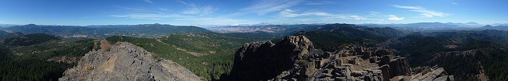
There are several trails near Pilot Rock which can be accessed via a forest road that ends at a parking lot approximately 1 mile (1.6 km) northwest of the rock. The main trail, part of the Pacific Crest Trail, travels southeast towards the rock for about 1⁄5 mile (0.32 km), before branching into two trails.[10][12] The left branch is the northbound continuation of the Pacific Crest Trail, while the right fork is the summit trail.[12] The steep summit trail is about 1 mile (1.6 km) long, and gains approximately 808 feet (246 m) in elevation.[7][10] At the summit, there are views of landmarks such as Mount Shasta, the Trinity Alps, and Mount McLoughlin.[7][10][12][13]
See also
Wikimedia Commons has media related to Pilot Rock (Jackson County, Oregon).
References
- ^ a b c d e f g h i "Pilot Rock" (PDF). Bureau of Land Management. Retrieved September 5, 2013.
- ^ a b c d e f g Fattig, Paul (June 11, 2009). "Rock of Ages". Mail Tribune. Medford, Oregon. Retrieved June 11, 2009.
- ^ "Pilot Rock". Geographic Names Information System. United States Geological Survey, United States Department of the Interior. November 28, 1980. Retrieved September 5, 2013.
- ^ a b c d e f g h i j k "Monument Guide" (PDF). Bureau of Land Management. Retrieved September 5, 2013.
- ^ a b c d Bishop, Ellen; Allen, John (2004). Hiking Oregon's Geology (2nd ed.). Seattle, Washington: The Mountaineers Books. pp. 39–41. ISBN 978-0-89886-847-0. OCLC 429920546. Retrieved June 11, 2009.
- ^ Bishop, Ellen (2003). In Search of Ancient Oregon. Portland, Oregon: Timber Press. p. 120. ISBN 978-0-88192-590-6. OCLC 51614008.
- ^ a b c d Bond, Barbara I. (2005). 75 Scrambles in Oregon. Seattle, Washington: The Mountaineers Books. pp. 118–120. ISBN 978-0-89886-550-9. OCLC 57414670. Retrieved June 11, 2009.
- ^ Gray, Dennis J. (1987). "The Takelma and Their Athapascan Neighbors" (PDF). Southern Oregon University. p. 76. Archived from the original (PDF) on December 5, 2013. Retrieved June 14, 2009.
- ^ a b c d Hoover, Mildred Brooke; Rensch, Hero Eugene; Rensch, Ethel Grace; Abeloe, William N.; Kyle, Douglas E. (2002). Historic Spots in California (5th ed.). Stanford University Press. p. 482. ISBN 978-0-8047-4482-9. OCLC 50735628. Retrieved June 12, 2009.
- ^ a b c d Bernstein, Art (2001). Hiking Oregon's Southern Cascades and Siskiyous. Guilford, Connecticut: Globe Pequot Press. pp. 221–222. ISBN 978-1-56044-898-3. OCLC 47292698. Retrieved June 12, 2009.
- ^ Currin, Rebecca; Amsberry, Kelly; Meinke, Robert (2004). "Developing biogeographically based population introduction protocols for at-risk plant species of the interior valleys of southwestern Oregon" (PDF). United States Fish and Wildlife Service. p. 3. Retrieved June 14, 2009.
- ^ a b c Gerald, Paul (2007). Day and Overnight Hikes: Oregon's Pacific Crest Trail. Birmingham, Alabama: Menasha Ridge Press. pp. 29–33. ISBN 978-0-89732-973-6. OCLC 76925233. Retrieved June 11, 2009.
- ^ Sullivan, William (April 21, 2009). "Into The Wilds". The Register-Guard. Eugene, Oregon. Retrieved June 14, 2009.
- v
- t
- e
- Applegate Peak
- Aspen Butte
- Bald Crater
- Ball Butte
- Barlow Butte
- Bear Butte
- Belknap Crater
- Black Butte
- Black Crater
- Broken Top
- Buckskin Butte
- Cache Mountain
- Chinquapin Mountain
- Clear Lake Butte
- Cleetwood
- Crater Lake
- Crater Mountain
- Crater Peak
- Cryder Butte
- Cupit Mary Mountain
- Danger Bay
- Davis Lake Volcanic Field
- Davis Mountain
- Desert Cone
- Diamond Peak
- Dry Butte
- Dutton Cliff
- Egan Cone
- Forgotten Cone
- Fort Butte
- Frog Lake Buttes
- Fuji Mountain
- Garfield Peak
- Greylock Mountain
- Grouse Hill
- Hamner Butte
- Hayrick Butte
- Hillman Peak
- Hogg Rock
- Hoodoo Butte
- Howlock Mountain
- Irish Mountain
- Katsuk Butte
- Kwolh Butte
- Lemiti Butte
- Le Conte Crater
- Llao Bay
- Llao Rock
- Little Aspen Butte
- Little Belknap
- Little Brother
- Little Cache Mountain
- Little Chinquapin Mountain
- Little Nash Crater
- Lolah Butte
- Lost Lake Cinder Cones
- Lookout Butte
- Lookout Mountain
- Lumrum Butte
- Maiden Peak
- Maklaks Crater
- Maklaks Mountain
- Melvin Butte
- Merriam Cone
- Merriam Point
- Mount Bachelor
- Mount Bailey
- Mount Carmine
- Mount Harriman
- Mount Hood
- Mount Jefferson
- Mount Mazama
- Mount McLoughlin
- Mount Multnomah (unconfirmed)
- Mount Ray
- Mount Scott (Klamath)
- Mount Thielsen
- Mount Washington
- Mount Wilson
- Nash Crater
- North Pinhead Butte
- North Wilson
- Odell Butte
- Oregon's Matterhorns
- Olallie Butte
- Peavine Mountain
- Pelican Butte
- Phantom Ship
- Pinhead Buttes
- Pine Marten Mountain
- Pothole Butte
- Redcloud
- Red Box
- Red Cone
- Red Crater
- Ringo Butte
- Robinson Butte
- Rock Butte
- Rock Mesa
- Royce Mountain
- Rustler Peak
- Sand Mountain
- Sand Mountain Volcanic Field
- Scout Hill
- Sentinel Rock
- Sharp Peak
- Sheridan Mountain
- Siah Butte
- Sisi Butte
- South Belknap
- South Pinhead Butte
- Summit Butte
- Talapus Butte
- Teardrop Pool
- The Husband
- The Pinnacle
- The Twins
- The Wife
- Three Fingered Jack
- Three Sisters (North Sister, Middle Sister, South Sister)
- Three Trappers
- Timber Crater
- Tom Dick and Harry Mountain
- Tot Mountain
- Triangle Hill
- Triangle Peak
- Tumalo Mountain
- Tumalo Volcanic Center
- Twin Craters
- Union Peak
- Waldo Mountain
- West Pinhead Butte
- Whiteface Peak
- Williamson Mountain
- Wizard Island
- Zigzag Mountain
- Angels Rest
- Armet Creek
- Baldy
- Battle Ax
- Bone Mountain
- Boring Lava Field
- Cascade Head
- Chamberlain Hill
- Clatsop Butte
- Cook's Butte
- Crescent Mountain
- Devil's Rest
- East Buttes
- French's Dome
- Elk Point
- Elk Rock Island
- Grass Mountain
- Grizzly Peak
- Harter Mountain
- Highland Butte
- High Prairie
- Hunsinger Peak
- Indian Mountain
- Iron Mountain
- Kelly Butte
- Larch Mountain
- Laurel Mountain
- Lenhart Butte
- Little Butte Volcanics
- Little Pilot Rock
- Lookout Point
- Lost Lake Butte
- Marys Peak
- Mount Ashland
- Mount Defiance
- Mount Hebo
- Mount Pisgah
- Mount Scott (Clackamas)
- Mount Sylvania
- Mount Tabor
- Mount Talbert
- Nesmith Point
- Olson Mountain
- Oregon's Matterhorns
- Palmer Peak
- Pepper Mountain
- Pilot Rock
- Powell Butte
- Rocky Butte
- Rogers Peak
- Ross Mountain
- Roxy Ann Peak
- Saddle Mountain
- Scout Camp
- Siletz River Volcanics
- Snow Peak
- Southern Oregon Coast Range
- Spencer Butte
- Sunshine Rock
- Swede Hill
- Three Pyramids
- Tualatin Mountains
- TV Hill
- Upper and Lower Table Rock
- Walker Peak
- Willamette National Cemetery
- Bald Mountain
- Bald Mountain Caldera
- Barnes Butte
- Bly Mountain
- China Hat
- Cline Buttes
- Crooked River Caldera
- Deschutes Formation
- Hager Mountain
- Horse Ridge
- Gearhart Mountain
- Gray Butte
- Grizzly Mountain
- Lava Butte (Newberry/Tumalo)
- Monkeyface
- Newberry Volcano
- Ochoco Mountains
- Oregon Badlands Wilderness
- Paulina Peak
- Pilot Butte
- Pine Mountain
- Powell Buttes
- Round Butte
- Smith Rock
- Smith Rock State Park
- Tea Table Mountain
- Wildcat Mountain
- Wildcat Mountain Caldera
- Yainax Butte
- Yainax Ridge
- Yamsay Mountain
- Big Hole
- Black Hills
- Chalk Basin
- Clarks Butte
- Clarno Unit
- Devils Garden Volcanic Field
- Dooley Mountain
- Diamond Craters
- Doherty Slide
- Drake Peak
- Fort Rock
- Fort Rock-Christmas Lake Valley Basin
- Four Craters Lava Field
- Glass Buttes
- Hager Mountain
- Harney Basin
- Harney Basin Volcanic Field
- Hole-in-the-Ground
- Jackies Butte
- John Day Fossil Beds National Monument
- Jordan Craters
- Lambert Rocks
- Lava Butte (Basin and Range)
- Mahogany Mountain
- Malheur Butte
- Modoc Plateau
- Mutton Mountains
- Pillars of Rome
- Poker Jim Ridge
- Powder River Volcanics
- Powder River Volcanics
- Saddle Butte
- Squaw Ridge Lava Field
- Steens Mountain
- Strawberry Mountain
- Strawberry Volcanics
- Tower Mountain
- Warner Peak


