Rabbit Hash Historic District
Historic district in Kentucky, United States
United States historic place
Rabbit Hash Historic District | |
 | |
38°56′32″N 84°50′45″W / 38.94222°N 84.84583°W / 38.94222; -84.84583 | |
| Area | 33 acres (13 ha) |
|---|---|
| MPS | Boone County, Kentucky MPS |
| NRHP reference No. | 03001231[1] |

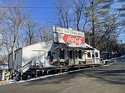
The Rabbit Hash Historic District in Rabbit Hash, Kentucky was added to the National Register of Historic Places on December 4, 2003. It includes 330 acres (1.3 km2), 12 buildings, 6 structures, and 3 objects around 10021-10410 Lower River Rd.[2][3] The Rabbit Hash General Store, one of the addresses in the District, had already been listed since February 2, 1989.[1]
References
- ^ a b "National Register Information System". National Register of Historic Places. National Park Service. July 9, 2010.
- ^ "National Register of Historic Places Listings December 12, 2003". National Park Service. Retrieved August 24, 2008.
- ^ "KENTUCKY - Boone County - Historic Districts". Retrieved August 24, 2008.
External links
- "Rabbit Hash," Chronicles of Boone County, Boone County Public Library (KY)
- v
- t
- e
- Architectural style categories
- Contributing property
- Historic district
- History of the National Register of Historic Places
- Keeper of the Register
- National Park Service
- Property types
- List of U.S. National Historic Landmarks by state:
- Alabama
- Alaska
- Arizona
- Arkansas
- California
- Colorado
- Connecticut
- Delaware
- Florida
- Georgia
- Hawaii
- Idaho
- Illinois
- Indiana
- Iowa
- Kansas
- Kentucky
- Louisiana
- Maine
- Maryland
- Massachusetts
- Michigan
- Minnesota
- Mississippi
- Missouri
- Montana
- Nebraska
- Nevada
- New Hampshire
- New Jersey
- New Mexico
- New York
- North Carolina
- North Dakota
- Ohio
- Oklahoma
- Oregon
- Pennsylvania
- Rhode Island
- South Carolina
- South Dakota
- Tennessee
- Texas
- Utah
- Vermont
- Virginia
- Washington
- West Virginia
- Wisconsin
- Wyoming
 National Register of Historic Places portal
 Category


This article about a property in Boone County, Kentucky on the National Register of Historic Places is a stub. You can help Wikipedia by expanding it. |
- v
- t
- e
 | This Boone County, Kentucky state location article is a stub. You can help Wikipedia by expanding it. |
- v
- t
- e


