Racovița, Sibiu
You can help expand this article with text translated from the corresponding article in Romanian. (February 2009) Click [show] for important translation instructions.
- View a machine-translated version of the Romanian article.
- Machine translation, like DeepL or Google Translate, is a useful starting point for translations, but translators must revise errors as necessary and confirm that the translation is accurate, rather than simply copy-pasting machine-translated text into the English Wikipedia.
- Consider adding a topic to this template: there are already 328 articles in the main category, and specifying
|topic=will aid in categorization. - Do not translate text that appears unreliable or low-quality. If possible, verify the text with references provided in the foreign-language article.
- You must provide copyright attribution in the edit summary accompanying your translation by providing an interlanguage link to the source of your translation. A model attribution edit summary is
Content in this edit is translated from the existing Romanian Wikipedia article at [[:ro:Racovița, Sibiu]]; see its history for attribution. - You may also add the template
{{Translated|ro|Racovița, Sibiu}}to the talk page. - For more guidance, see Wikipedia:Translation.
Commune in Sibiu, Romania
(2020–2024) (2021-12-01)[2]
557195
Racovița (Racovița-Olt until 1931; German: Rakowitza or Rakevets; Hungarian: Oltrákovica or colloquially Rákovica) is a commune in Sibiu County, Transylvania, Romania. It has a population of 2,884 inhabitants (2002 census) and is composed of two villages, Racovița and Sebeșu de Sus (Oltfelsősebes).
The first official mention of the then-village was in a May 22, 1443 "gift" act of John Hunyadi. Church documents first mention the village on July 8, 1647, when George I Rákóczi names Ion din Ţichindeal as archpriest over 17 villages around Sibiu, including Racovița. The rich history of the village is linked to the military border with Transylvania established by empress Maria Theresa of Austria in 1765. At the time, Racovița was part of the 7th Company of the First Border Regiment in Orlat.
Starting in 1698, before the village was completely militarized, the village and its area were confronted with severe religious conflicts due to the decision made by the Alba-Iulia Orthodox Church to unite with the Catholic Church.
Soldiers and villagers participated enthusiastically in the Hungarian Revolution of 1848. Once the military border was abolished in 1851, important village members took initiative to manage the Regiment School Funds and became actively involved in the Transylvanian Association for Romanian Literature and the Culture of Romanian People.
During World War I, soldiers from Racovița served in the army from 1916 to 1918 and received distinctions for fighting against "Russian Poland", Galicia, Albania, Italy, Serbia. and even France.
Geography
Racovița Commune is situated at the base of Suru Peak (2,281 m or 7,484 ft) on the contact between the foothills of the Făgăraș Mountains and the low terrace of the floodplain, on the left bank of the river Olt, at an altitude of 385 meters.[3] The commune borders to the north and northeast with the town Avrig; the border, which extends from the confluence of the small river Mârșa with the Olt to the Sorliței Peak, was established after the year 1200[4] and is marked with border signs called 'morminți'.
-
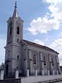 Holy Trinity Church, dedicated in 1887
 -
 The first document mentioning the locality, May 22, 1443
 -
 Toponymic map of Racovița village
 -
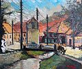 Painting of Racovița by Valeriu Pantazi
 -
![Racovița schoolhouse [ro]](//upload.wikimedia.org/wikipedia/commons/thumb/8/84/RO_SB_Racovita_schoolhouse.JPG/120px-RO_SB_Racovita_schoolhouse.JPG) Racovița schoolhouse [ro]
Racovița schoolhouse [ro]


![Racovița schoolhouse [ro]](http://upload.wikimedia.org/wikipedia/commons/thumb/8/84/RO_SB_Racovita_schoolhouse.JPG/120px-RO_SB_Racovita_schoolhouse.JPG)
References
- ^ "Results of the 2020 local elections". Central Electoral Bureau. Retrieved 14 June 2021.
- ^ "Populaţia rezidentă după grupa de vârstă, pe județe și municipii, orașe, comune, la 1 decembrie 2021" (XLS). National Institute of Statistics.
- ^ Altitudes are taken from the "Touristenkarte der Section "Hermannstadt" de S.K.V, Blatt II (Fogarascher Gebirge), Hermannstadt, 1921
- ^ S. Lupșa, Satul lui Gheorghe Lazăr, in "Mitropolia Ardealului", VII, nr.7-8/1962, p.483, n.5.
- v
- t
- e

- Alma
- Alțâna
- Apoldu de Jos
- Arpașu de Jos
- Ațel
- Axente Sever
- Bârghiș
- Bazna
- Biertan
- Blăjel
- Boița
- Brădeni
- Brateiu
- Bruiu
- Cârța
- Cârțișoara
- Chirpăr
- Cristian
- Dârlos
- Gura Râului
- Hoghilag
- Iacobeni
- Jina
- Laslea
- Loamneș
- Ludoș
- Marpod
- Merghindeal
- Micăsasa
- Mihăileni
- Moșna
- Nocrich
- Orlat
- Păuca
- Poiana Sibiului
- Poplaca
- Porumbacu de Jos
- Racovița
- Rășinari
- Râu Sadului
- Roșia
- Sadu
- Șeica Mare
- Șeica Mică
- Șelimbăr
- Slimnic
- Șura Mare
- Șura Mică
- Târnava
- Tilișca
- Turnu Roșu
- Valea Viilor
- Vurpăr


