Scheur
River in South Holland, Netherlands
| Scheur (The Rip) | |
|---|---|
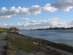 Near Maassluis | |
 Northwest part of the Rhine-Meuse delta showing the Scheur (s). | |
| Location | |
| Country | Netherlands |
| Province | South Holland |
| Physical characteristics | |
| Source | Nieuwe Maas Oude Maas |
| • location | Vlaardingen |
| Mouth | Nieuwe Waterweg |
• location | Rotterdam |
| Length | 13 km (8.1 mi) |
The Scheur (Dutch pronunciation: [ət ˈsxøːr]; Dutch for "The Rip") is a branch of the Rhine-Meuse delta in South Holland, Netherlands, that flows west from the confluence of the Oude Maas and Nieuwe Maas branches past the towns of Rozenburg and Maassluis. It continues as the Nieuwe Waterweg (New Waterway) to the North Sea.
Originally, the Scheur was the northern branch of the river around Rozenburg island and curved south a few kilometres past Maassluis to join the Nieuwe Maas again in the Maasmond ("Mouth of Meuse") estuary near Den Briel. When the Nieuwe Waterweg was completed in 1872, the Scheur was dammed off and connected to the east end of the Nieuwe Waterweg to form the new channelized main mouth of the Rhine-Meuse delta.


- v
- t
- e
Rijn
Rhin
- Current distributaries
- Waal
- Nederrijn
- IJssel
- Lek
- Merwede
- Boven Merwede
- Nieuwe Merwede
- Beneden Merwede
- Oude Maas
- Dordtsche Kil
- Noord
- Nieuwe Maas
- Scheur
- Nieuwe Waterweg
- Former distributaries
- Kromme Rijn
- Leidse Rijn
- Oude Rijn
- Hollandse IJssel
- Vecht
- Waaltje
- Brielse Maas
- Spui
- Current estuaries
- Nieuwe Waterweg
- IJsselmeer
- Former estuaries
- Hollands Diep
- Haringvliet
- Volkerak
- Krammer
- Grevelingen
- Keeten-Mastgat
- Oosterschelde
Maas
- Current distributaries
- Bergse Maas
- Amer
- Former distributaries
- Oude Maasje
- Afgedamde Maas
- Merwede
- Boven Merwede
- Beneden Merwede
- Oude Maas
- Dordtsche Kil
- Noord
- Nieuwe Maas
- Scheur
- Nieuwe Waterweg
- Current estuaries
- Former estuaries
- Hollands Diep
- Haringvliet
- Volkerak
- Krammer
- Grevelingen
- Keeten-Mastgat
- Oosterschelde
- Associated canals
- Heusden Canal
- Bergse Maas
- Maas–Waal Canal
Schelde
Escaut
- Current distributaries
- Western Scheldt
- Former distributaries
- Oosterschelde
- Eendracht
- Current estuaries
- Western Scheldt
- Former estuaries
- Oosterschelde
- Krammer
- Grevelingen
- Associated canals
- Scheldt–Rhine Canal
- Canal through Zuid-Beveland
- Canal through Walcheren
(directly draining
into the delta)
- Linge
- Mark
- Donge
- Rotte
- Oude IJssel
Peninsulas
- Rozenburg
- IJsselmonde
- Het Eiland van Dordt
- Voorne and Putten
- Hoeksche Waard
- Tiengemeten
- Goeree-Overflakkee
- Schouwen-Duiveland
- Tholen
- Sint Philipsland
- Walcheren
- Noord-Beveland
- Zuid-Beveland
- Delta Works
- Verdronken Land van Reimerswaal
- Verdronken Land van Saeftinghe
- St. Elizabeth's flood (1421)
- St. Felix's Flood
- All Saints' Flood (1570)
51°54′54″N 4°14′31″E / 51.915°N 4.242°E / 51.915; 4.242


