Slovak-Moravian Carpathians
The Slovak-Moravian Carpathians (CZ/SK: Slovensko-moravské Karpaty) are the mountain ranges along the border of the Czech Republic and Slovakia. Before the Treaty of Trianon in 1920, it was known in Hungarian as Magyar-morva határhegység 'the Hungarian-Moravian border mountains'.[1]
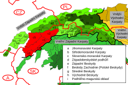
Geologically these ranges are part of the Outer Western Carpathians group of the Western Carpathians, and are composed mainly of flysch sediment.

The Slovak-Moravian Carpathians consist of:
- White Carpathians (CZ: Bílé Karpaty, SK: Biele Karpaty), which encompasses the Biele Karpaty Protected Landscape Area within Slovakia and the Bílé Karpaty Protected Landscape Area in the Czech Republic
- Javorníky (CZ+SK; "Maple Mountains"), including the two highest points in these ranges, Veľký Javorník at 3,514 feet (1,071 metres) and Malý Javorník (1,021 metres)
- Myjava Hills (SK: Myjavská pahorkatina), rugged highlands along the Myjava River
- Váh Valley Land (SK: Považské podolie) along the Váh River
- Vizovice Highlands (CZ: Vizovická vrchovina), rugged highlands within the Zlín Region, including the highest peak, Klášťov
References
- ^ "Magyar-morva határhegység - Lexikon ::".
Wikimedia Commons has media related to Slovensko-moravské Karpaty.
- v
- t
- e
Divisions, Groups, and Ranges of the Carpathian Mountains
| Inner Western | |
|---|---|
| Outer Western |
|

| Inner Eastern | |
|---|---|
| Outer Eastern |
- Hungarian Carpathians
- Polish Carpathians
- Romanian Carpathians
- Serbian Carpathians
- Slovak Carpathians
- Ukrainian Carpathians
49°3′36″N 17°57′36″E / 49.06000°N 17.96000°E / 49.06000; 17.96000
| Authority control databases: National |
|
|---|


