Someren
Town and municipality in North Brabant, Netherlands

Flag

Coat of arms

Location in North Brabant
(January 2021)[4]
5710–5715
Someren (Dutch pronunciation: [ˈsoːmərə(n)] ⓘ) is a municipality and town in the province of North Brabant in the Southern Netherlands. As of January 2019, the municipality had 19,322 inhabitants, with over half of the population residing in the town. Someren, just south of Helmond and to the north of Weert, Limburg, is located on the provincial border with Limburg.
The spoken dialect is Peellands (an East Brabantian dialect, which is very similar to colloquial Dutch).[5] In Brabantian, Someren is known as Zummere.
Population centres
- Someren-Eind
- Someren-Heide
- Someren
- Lierop
Topography

Dutch Topographic map of the municipality of Someren, June 2015
Notable people
- Antonius Lambertus Maria Hurkmans (born 1944 in Someren) Bishop emeritus of the Roman Catholic Diocese of 's-Hertogenbosch
- Marie-José de Groot (born 1966 in Someren) a Dutch rower, competed at the 1992 Summer Olympics
- Vincent Voorn (born 1984 in Someren) a Dutch show jumper, competed in the 2008 Summer Olympics
- Evy Kuijpers (born 1995 in Lierop) a Dutch professional racing cyclist
Gallery
-
 Someren, townhall
 -
 Border of North Brabant and Limburg alongside Zuid-Willemsvaart
 -
 Someren, windmill: standerdmolen Den Evert
 -
 Somerense Heide
 -
 Someren Ruimtelijk Object Jan Samsom
 -
 Sluis (canal lock) 13 in Zuid-Willemsvaart
 -
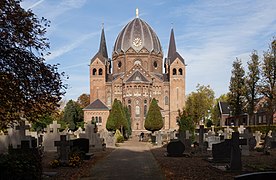 Lierop, church: Heilige Naam Jezuskerk


References
- ^ "College van burgemeester en wethouders" [Board of mayor and aldermen] (in Dutch). Gemeente Someren. Archived from the original on 6 June 2014. Retrieved 4 June 2014.
- ^ "Kerncijfers wijken en buurten 2020" [Key figures for neighbourhoods 2020]. StatLine (in Dutch). CBS. 24 July 2020. Retrieved 19 September 2020.
- ^ "Postcodetool for 5711EK". Actueel Hoogtebestand Nederland (in Dutch). Het Waterschapshuis. Retrieved 4 June 2014.
- ^ "Bevolkingsontwikkeling; regio per maand" [Population growth; regions per month]. CBS Statline (in Dutch). CBS. 1 January 2021. Retrieved 2 January 2022.
- ^ Jos & Cor Swanenberg: Taal in stad en land: Oost-Brabants, ISBN 9012090105
External links
 Media related to Someren at Wikimedia Commons
- Official website
Places adjacent to Someren | ||||||||||||||||
|---|---|---|---|---|---|---|---|---|---|---|---|---|---|---|---|---|
| ||||||||||||||||


- v
- t
- e
Municipalities of North Brabant
- Alphen-Chaam
- Altena
- Asten
- Baarle-Nassau
- Bergeijk
- Bergen op Zoom
- Bernheze
- Best
- Bladel
- Boekel
- Boxtel
- Breda
- Cranendonck
- Deurne
- Dongen
- Drimmelen
- Eersel
- Eindhoven
- Etten-Leur
- Geertruidenberg
- Geldrop-Mierlo
- Gemert-Bakel
- Gilze en Rijen
- Goirle
- Halderberge
- Heeze-Leende
- Helmond
- 's-Hertogenbosch
- Heusden
- Hilvarenbeek
- Laarbeek
- Land van Cuijk
- Loon op Zand
- Maashorst
- Meierijstad
- Moerdijk
- Nuenen, Gerwen en Nederwetten
- Oirschot
- Oisterwijk
- Oosterhout
- Oss
- Reusel-De Mierden
- Roosendaal
- Rucphen
- Sint-Michielsgestel
- Someren
- Son en Breugel
- Steenbergen
- Tilburg
- Valkenswaard
- Veldhoven
- Vught
- Waalre
- Waalwijk
- Woensdrecht
- Zundert

- See also
- Netherlands
- Provinces
- Municipalities
Authority control databases | |
|---|---|
| International |
|
| National |
|
| Geographic |
|


