Tarata Province
Province in Tacna, Peru
Tarata | |
|---|---|
Province | |
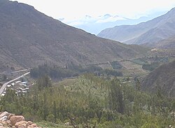 Valley of the Estique River, Tarata Province | |
 Location of Tarata in the Tacna Region | |
| Country | Peru |
| Region | Tacna |
| Capital | Tarata |
| Government | |
| • Mayor | José Luis Ticona Sanjinez (2007) |
| Area | |
| • Total | 2,819.96 km2 (1,088.79 sq mi) |
| Population | |
| • Total | 6,630 |
| • Density | 2.4/km2 (6.1/sq mi) |
| UBIGEO | 2304 |
Tarata is one of four provinces in the Tacna Region in southern Peru. Its capital is Tarata city.
Geography
The Tarata Province is bounded to the north by the Candarave Province and the Puno Region, to the east by Bolivia, and to the south and west by the Tacna Province.
The Barroso mountain range traverses the district. Some of the highest mountains of the province are listed below:[1]
- Antajawi
- Chila
- Chunta Qullu
- Churi Qullu
- Churi Wiqu
- Ch'illiwa
- Ch'uxñuma
- Inka Apachita
- Iñuma
- Jach'a T'aja Sirka
- Jach'a Qullu
- Janq'u Qullu
- Jichu Qullu
- Jisk'a Qullu
- Juqhuri
- Khuruña
- Laram Qullu
- Lluqu Qullu
- Lluqu Lluquni
- Pä Qullu
- Pharaquta
- Phuru Phuruni
- Phusnu Pullawi
- P'isaqani
- Qutan Willk'i
- Qutañani
- Q'asiri
- Tawa Qullu
- Taypi Qullu
- Timillu Qullu
- Titiri
- Wallatiri
- Warawarani
- Wariri
- Wila Uqharani
- Wila Qullu
- Wiqu
- Yana K'achi
Political division
The province is divided into eight districts (Spanish: distritos, singular: distrito), each of which is headed by a mayor (alcalde):
Ethnic groups
The province is inhabited by indigenous citizens of Aymara descent. Spanish, however, is the language which the majority of the population (82.31%) learnt to speak in childhood, 17.12% of the residents started speaking using the Aymara language (2007 Peru Census).[2]
See also
- Pharaquta
- Wilaquta
Sources
- ^ escale.minedu.gob.pe - UGEL map of the Tarata Province (Tacna Region)
- ^ inei.gob.pe Archived 2013-01-27 at the Wayback Machine INEI, Peru, Censos Nacionales 2007

Authority control databases | |
|---|---|
| International |
|
| National |
|
17°28′29″S 70°01′57″W / 17.47463°S 70.03262°W / -17.47463; -70.03262
 | This Tacna Region geography article is a stub. You can help Wikipedia by expanding it. |
- v
- t
- e


