Taulaga
Village in American Samoa, United States
Taulaga | |
|---|---|
Village | |
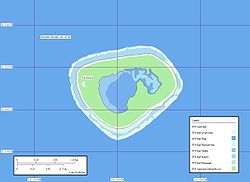 Location on Swains Island | |
| Country |  United States United States |
| Territory |  American Samoa American Samoa |
| Population (2020) | |
| • Total | 0 |
Taulaga is a deserted village located northwest of the atoll on Swains Island, American Samoa. It is close to the village of Etena which is also deserted.[1]
It was hit heavily by Cyclone Percy in 2005.
The village consisted of a church, a communications center, and a school.
According to the 2010 census, it had a population of 17. The 2020 census recorded no people living on Swains Island, suggesting the village has no residents.[2]
References
- v
- t
- e
Territory of American Samoa
Pago Pago (capital), Fagatogo (seat of government)
| Airports |
|
|---|
| Education | |
|---|---|
| Religion |
|
- Aʻasu
- Afao
- Āfono
- Agugulu
- Alao
- Alaufau
- Ālega
- Ālōfau
- Amalau
- Amaluia
- ʻAmanave
- Amaua
- Āmouli
- Ānua
- ʻAoa
- Aʻoloau
- Asili
- Atuʻu
- ʻAūa
- ʻAuʻasi
- Aʻumi
- Aunuʻu
- Auto
- Avaio
- Etena
- Fagaʻalu
- Fagaʻitua
- Fagaliʻi
- Fagamalo
- Faganeanea
- Fagasā
- Fagatogo (Malaloa)
- Faiava
- Faʻilolo
- Faleāsao
- Faleniu
- Fatumafuti
- Fitiuta (Maia and Leusoaliʻi)
- Fūtiga
- ʻIliʻili
- Lalomoana
- Lauliʻi
- Leloaloa
- Leone
- Lumā
- Malaeimi
- Malaeloa/Aitulagi
- Malaeola/Itūʻau
- Mālōatā
- Mapusaga
- Masausi
- Masefau
- Matuʻu
- Mesepa
- Nuʻuuli
- Nua
- Ofu
- Olosega
- Onenoa
- Pagai
- Pago Pago
- Pavaʻiaʻi
- Poloa
- Saʻilele
- Satala
- Seʻetaga
- Siʻufaga
- Sili
- Taulaga
- Tāfuna (Ottoville)
- Taputimu
- Tula
- Utulei
- Utumea East
- Utumea West
- Vailoatai
- Vaitogi
- Vatia
11°03′18″S 171°05′17″W / 11.055°S 171.088°W / -11.055; -171.088
 | This American Samoa location article is a stub. You can help Wikipedia by expanding it. |
- v
- t
- e


