Toowoon Bay, New South Wales
Suburb of Central Coast, New South Wales, Australia
| Toowoon Bay Central Coast, New South Wales | |||||||||||||||
|---|---|---|---|---|---|---|---|---|---|---|---|---|---|---|---|
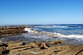 Toowoon Bay c. 2010 | |||||||||||||||
 | |||||||||||||||
| Population | 548 (2011 census)[1] | ||||||||||||||
| • Density | 910/km2 (2,370/sq mi) | ||||||||||||||
| Postcode(s) | 2261 | ||||||||||||||
| Elevation | 11 m (36 ft) | ||||||||||||||
| Area | 0.6 km2 (0.2 sq mi) | ||||||||||||||
| Location |
| ||||||||||||||
| LGA(s) | Central Coast Council | ||||||||||||||
| Parish | Tuggerah | ||||||||||||||
| State electorate(s) | The Entrance | ||||||||||||||
| Federal division(s) | Dobell | ||||||||||||||
| |||||||||||||||

Toowoon Bay is a suburb of the Central Coast region of New South Wales, Australia, located on a peninsula between Tuggerah Lake and the Pacific Ocean south of The Entrance. It is part of the Central Coast Council local government area.
Location
Toowoon Bay's village centre is within The Entrance district and is situated at the intersection of Toowoon Bay Rd and Bay Rd (which is a tourist route to The Entrance).
The Toowoon Bay beach is located at the eastern end of Toowoon Bay Rd with access from Bay Road (250 metres south of the village intersection). The beach is patrolled by Central Coast Council Lifeguard's during week days and lifesaver volunteers from the Toowoon Bay SLSC on weekends during summer. The Toowoon Bay SLSC has a strong local following within The Entrance district. In 2005, the Toowoon Bay SLSC had a new clubhouse constructed.
The beach is popular for swimming and fishing, with a gentle surf as the beach is protected from winds and strong currents. Sail boarding and kite surfing are popular out on the bay.
The closest shopping centre with full supermarket, banks, and general retail is at The Entrance. It is also at The Entrance where recreation facilities including the ocean baths, cricket pitch, and memorial park are located.
Education
Children from Toowoon Bay are in the area for The Entrance Public School.
Transport
Toowoon Bay is serviced by The Entrance Red Bus Service with one route to The Entrance. The closest railway station is Tuggerah railway station which is serviced by the Central Coast & Newcastle Line.
References
- ^ Australian Bureau of Statistics (31 October 2012). "Toowoon Bay (State Suburb)". 2011 Census QuickStats. Retrieved 24 October 2013.

33°21′25″S 151°29′35″E / 33.357°S 151.493°E / -33.357; 151.493
- v
- t
- e
Suburbs of the Central Coast, New South Wales
and localities
- Alison
- Avoca Beach
- Bar Point
- Bateau Bay
- Bensville
- Berkeley Vale
- Blackwall
- Blue Bay
- Blue Haven
- Booker Bay
- Bouddi
- Box Head
- Budgewoi
- Budgewoi Peninsula
- Buff Point
- Bushells Ridge
- Calga
- Canton Beach
- Cedar Brush Creek
- Central Mangrove
- Chain Valley Bay
- Charmhaven
- Cheero Point
- Chittaway Bay
- Chittaway Point
- Cogra Bay
- Colongra
- Copacabana
- Crangan Bay
- Daleys Point
- Davistown
- Dooralong
- Doyalson
- Doyalson North
- Durren Durren
- East Gosford
- Empire Bay
- Erina
- Erina Heights
- Ettalong Beach
- Forresters Beach
- Fountaindale
- Glenning Valley
- Glenworth Valley
- Gorokan
- Gosford
- Green Point
- Greengrove
- Gunderman
- Gwandalan
- Halekulani
- Halloran
- Hamlyn Terrace
- Hardys Bay
- Holgate
- Horsfield Bay
- Jilliby
- Kangy Angy
- Kanwal
- Kariong
- Kiar
- Killarney Vale
- Killcare
- Killcare Heights
- Kincumber
- Kincumber South
- Kingfisher Shores
- Koolewong
- Kulnura
- Lake Haven
- Lake Munmorah
- Lemon Tree
- Lisarow
- Little Jilliby
- Little Wobby
- Long Jetty
- Lower Mangrove
- MacMasters Beach
- Magenta
- Mangrove Creek
- Mangrove Mountain
- Mannering Park
- Mardi
- Marlow
- Matcham
- Moonee
- Mooney Mooney
- Mooney Mooney Creek
- Mount Elliot
- Mount White
- Narara
- Niagara Park
- Norah Head
- Noraville
- North Avoca
- North Gosford
- Ourimbah
- Palm Grove
- Palmdale
- Patonga
- Pearl Beach
- Peats Ridge
- Phegans Bay
- Picketts Valley
- Point Clare
- Point Frederick
- Pretty Beach
- Ravensdale
- Rocky Point
- San Remo
- Saratoga
- Shelly Beach
- Somersby
- Spencer
- Springfield
- St Huberts Island
- Summerland Point
- Tacoma
- Tacoma South
- Tascott
- Ten Mile Hollow
- Terrigal
- The Entrance
- The Entrance North
- Toowoon Bay
- Toukley
- Tuggerah
- Tuggerawong
- Tumbi Umbi
- Umina Beach
- Upper Mangrove
- Wadalba
- Wagstaffe
- Wallarah
- Wamberal
- Warnervale
- Watanobbi
- Wendoree Park
- West Gosford
- Wisemans Ferry
- Wondabyne
- Woongarrah
- Woy Woy
- Woy Woy Bay
- Wyee
- Wyoming
- Wyong
- Wyong Creek
- Wyongah
- Yarramalong
- Yattalunga
other waterways
points of interest
 | This Central Coast geography article is a stub. You can help Wikipedia by expanding it. |
- v
- t
- e


