Vranjska Banja
Town and city municipality in Southern and Eastern Serbia, Serbia
Vranjska Banja Врањска Бања (Serbian) | |
|---|---|
Town and city municipality | |
 | |
| 42°33′20″N 21°59′30″E / 42.55556°N 21.99167°E / 42.55556; 21.99167 | |
| Country |  Serbia Serbia |
| Region | Southern and Eastern Serbia |
| District | Pčinja District |
| City | Vranje |
| Area | |
| • Urban | 7.83 km2 (3.02 sq mi) |
| • Municipality | 258.37 km2 (99.76 sq mi) |
| Population (2011)[2] | |
| • Urban | 5,347 |
| • Urban density | 680/km2 (1,800/sq mi) |
| • Municipality | 9,580 |
| • Municipality density | 37/km2 (96/sq mi) |
| Time zone | UTC+1 (CET) |
| • Summer (DST) | UTC+2 (CEST) |
| Postal code | 17542 |
| Area code | +381(0)17 |
| Vehicle registration | VR |
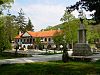
The City municipality of Vranjska Banja (Serbian Cyrillic: Градска општина Врањска Бања, romanized: Gradska opština Vranjska Banja) is a town and one of two city municipalities which constitute the City of Vranje. It is also one of the spa resorts in Serbia. Located 12 km (7 mi) northeast from the city of Vranje, it is surrounded by forests and rolling hills. A restaurant by the old clinic is situated at the end of the town.
The municipality has a population of 9,580 inhabitants, while the urban area has 5,347 inhabitants.
History
There are many excavations of early Byzantine fortresses in the region, all abandoned in the 6th and 7th century when the Slavs permanently settled in the area.
Demographics
| Year | Pop. | ±% p.a. |
|---|---|---|
| 1948 | 12,895 | — |
| 1953 | 13,104 | +0.32% |
| 1961 | 13,153 | +0.05% |
| 1971 | 13,730 | +0.43% |
| 1981 | 12,830 | −0.68% |
| 1991 | 11,972 | −0.69% |
| 2002 | 11,049 | −0.73% |
| 2011 | 9,580 | −1.57% |
| Source: [3] | ||
Spa
The Vranjska Banja resort thermal spring, with discharge temperatures of 96°C (205°F), are the hottest geothermal spring in Serbia.[4] The spa water contains high levels of hydrogen sulfide (H2S), and has positive effects on illnesses related to rheumatism, skin conditions, neurological problems and others. Vranjska Banja offers short tours to nearby cities like Vranje, Vladičin Han, Surdulica and the Vlasina Lake. It is situated close to the main railroad, connecting Belgrade and Athens.
See also
References
- ^ "Насеља општине Врањска Бања" (pdf). stat.gov.rs (in Serbian). Statistical Office of Serbia. Retrieved 22 October 2019.
- ^ Попис становништва, домаћинстава и станова 2011. у Републици Србији or 2011 Census of Population, Households and Dwellings in the Republic of Serbia (in Serbian). Statistical Office of the Republic of Serbia. 2012. ISBN 978-86-6161-023-3.
- ^ "2011 Census of Population, Households and Dwellings in the Republic of Serbia" (PDF). stat.gov.rs. Statistical Office of the Republic of Serbia. Archived from the original (PDF) on 14 July 2014. Retrieved 11 January 2017.
- ^ "Reservoir Capital Corp.: 20MW Potential Estimated for the Vranjska Banja Geothermal Project". Retrieved 3 February 2012.
Further reading
- Спасић, Н. "Врањска Бања." (2005).
External links
Wikimedia Commons has media related to Vranjska Banja.
- Info – portal grada Vranja
- v
- t
- e
City of Vranje
- City municipality of Vranje
- Vranjska Banja
- Aleksandrovac
- Babina Poljana
- Barbarušince
- Barelić
- Beli Breg
- Bojin Del
- Bresnica
- Bujkovac
- Buljesovce
- Buštranje
- Čestelin
- Crni Lug
- Crni Vrh
- Ćukovac
- Ćurkovica
- Davidovac
- Dobrejance
- Donja Otulja
- Donje Punoševce
- Donje Trebešinje
- Donje Žapsko
- Donji Neradovac
- Dragobužde
- Drenovac
- Dubnica
- Duga Luka
- Dulan
- Dupeljevo
- Golemo Selo
- Gornja Otulja
- Gornje Punoševce
- Gornje Trebešinje
- Gornje Žapsko
- Gornji Neradovac
- Gradnja
- Gumerište
- Izumno
- Katun
- Klašnice
- Klisurica
- Koćura
- Kopanjane
- Korbevac
- Korbul
- Kriva Feja
- Kruševa Glava
- Kumarevo
- Kupinince
- Lalince
- Lepčince
- Leva Reka
- Lipovac
- Lukovo
- Margance
- Mečkovac
- Mijakovce
- Mijovce
- Milanovo
- Milivojce
- Moštanica
- Nastavce
- Nesvrta
- Nova Brezovica
- Oblička Sena
- Ostra Glava
- Panevlje
- Pavlovac
- Preobraženje
- Prevalac
- Prvonek
- Ranutovac
- Rataje
- Ribnice
- Ristovac
- Roždace
- Rusce
- Sebevranje
- Sikirje
- Slivnica
- Smiljević
- Soderce
- Srednji Del
- Stance
- Stara Brezovica
- Stari Glog
- Strešak
- Stropsko
- Struganica
- Studena
- Surdul
- Suvi Dol
- Tesovište
- Tibužde
- Toplac
- Trstena
- Tumba
- Urmanica
- Uševce
- Viševce
- Vlase
- Vrtogoš
- Zlatokop
- White Bridge
- Markovo Kale
- Church of Saint Nicholas
- Krstata Džamija
- Saborni hram Sv. Troice
- Česma Đerenka
- Pašin konak
- Eparchy of Vranje


 | This Pčinja District, Serbia location article is a stub. You can help Wikipedia by expanding it. |
- v
- t
- e


