Wuhua County
County in Guangdong, People's Republic of China
Wuhua 23°46′N 115°42′E / 23.767°N 115.700°E / 23.767; 115.700 | |
|---|---|
| Country | People's Republic of China |
| Province | Guangdong |
| Prefecture-level city | Meizhou |
| Area | |
| • Total | 3,226 km2 (1,246 sq mi) |
| Time zone | UTC+8 (China Standard) |
Wuhua County (simplified Chinese: 五华县; traditional Chinese: 五華縣; pinyin: Wǔhuá Xiàn, Hakka: Ng-Fa) is a county under the jurisdiction of the prefecture-level city of Meizhou in the east of Guangdong Province, China.
Names
Wuhua was formerly known as Changle (长乐; 長樂).
Ethno-linguistic make-up
Wuhua is noted for its large Hakka population.
Administrative divisions
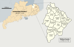 The county is responsible for the administration of 16 towns[1] with the seat of government located in Shuizhai (水寨镇).
- Zhuanshui (转水镇)
- Tanxia (潭下镇)
- Guotian (郭田镇)
- Shuanghua (双华镇)
- Meilin (梅林镇)
- Huayang (华阳镇)
- Huacheng (华城镇)
- Zhoujiang (周江镇)
- Shuizhai (水寨镇)
- Hedong (河东镇)
- Qiling (岐岭镇)
- Changbu (长布镇)
- Hengbei (横陂镇)
- Anliu (安流镇)
- Mianyang (棉洋镇)
- Longcun (龙村镇)
Climate
| Climate data for Wuhua (1991–2020 normals, extremes 1981–2010) | |||||||||||||
|---|---|---|---|---|---|---|---|---|---|---|---|---|---|
| Month | Jan | Feb | Mar | Apr | May | Jun | Jul | Aug | Sep | Oct | Nov | Dec | Year |
| Record high °C (°F) | 29.4 (84.9) | 32.2 (90.0) | 33.3 (91.9) | 35.1 (95.2) | 36.1 (97.0) | 38.0 (100.4) | 38.6 (101.5) | 38.4 (101.1) | 37.2 (99.0) | 35.2 (95.4) | 34.0 (93.2) | 29.9 (85.8) | 38.6 (101.5) |
| Mean daily maximum °C (°F) | 17.9 (64.2) | 19.8 (67.6) | 22.6 (72.7) | 26.7 (80.1) | 29.9 (85.8) | 32.0 (89.6) | 33.8 (92.8) | 33.3 (91.9) | 31.8 (89.2) | 28.8 (83.8) | 24.6 (76.3) | 19.4 (66.9) | 26.7 (80.1) |
| Daily mean °C (°F) | 12.5 (54.5) | 14.6 (58.3) | 17.7 (63.9) | 22.0 (71.6) | 25.3 (77.5) | 27.4 (81.3) | 28.7 (83.7) | 28.2 (82.8) | 26.9 (80.4) | 23.6 (74.5) | 19.0 (66.2) | 13.9 (57.0) | 21.6 (71.0) |
| Mean daily minimum °C (°F) | 8.8 (47.8) | 11.0 (51.8) | 14.2 (57.6) | 18.5 (65.3) | 22.0 (71.6) | 24.3 (75.7) | 25.2 (77.4) | 24.9 (76.8) | 23.4 (74.1) | 19.6 (67.3) | 15.0 (59.0) | 10.0 (50.0) | 18.1 (64.5) |
| Record low °C (°F) | −1.2 (29.8) | 1.3 (34.3) | 1.4 (34.5) | 7.8 (46.0) | 12.9 (55.2) | 17.4 (63.3) | 19.5 (67.1) | 21.6 (70.9) | 15.2 (59.4) | 8.1 (46.6) | 3.3 (37.9) | −2.5 (27.5) | −2.5 (27.5) |
| Average precipitation mm (inches) | 51.8 (2.04) | 66.4 (2.61) | 135.8 (5.35) | 171.4 (6.75) | 189.5 (7.46) | 249.7 (9.83) | 173.6 (6.83) | 197.0 (7.76) | 136.6 (5.38) | 40.4 (1.59) | 37.2 (1.46) | 44.2 (1.74) | 1,493.6 (58.8) |
| Average precipitation days (≥ 0.1 mm) | 7.3 | 10.0 | 14.1 | 14.5 | 17.4 | 18.4 | 15.0 | 16.8 | 11.9 | 4.9 | 5.4 | 6.1 | 141.8 |
| Average snowy days | 0.1 | 0 | 0 | 0 | 0 | 0 | 0 | 0 | 0 | 0 | 0 | 0 | 0.1 |
| Average relative humidity (%) | 74 | 76 | 78 | 78 | 79 | 81 | 76 | 79 | 77 | 71 | 72 | 72 | 76 |
| Mean monthly sunshine hours | 129.8 | 106.5 | 103.0 | 114.0 | 139.7 | 162.6 | 217.3 | 192.4 | 183.3 | 186.7 | 163.6 | 149.3 | 1,848.2 |
| Percent possible sunshine | 39 | 33 | 28 | 30 | 34 | 40 | 52 | 48 | 50 | 52 | 50 | 45 | 42 |
| Source: China Meteorological Administration[2][3] | |||||||||||||
See also
References
- ^ 五华县. National Bureau of Statistics of the People's Republic of China. 2013. Retrieved March 3, 2014. (in Chinese)
- ^ 中国气象数据网 – WeatherBk Data (in Simplified Chinese). China Meteorological Administration. Retrieved 28 May 2023.
- ^ 中国气象数据网 (in Simplified Chinese). China Meteorological Administration. Retrieved 28 May 2023.
External links
- Official website of the Wuhua People's Government (in Chinese)
- v
- t
- e
cities
| Guangzhou | |
|---|---|
| Shenzhen |
cities
| Shaoguan | |||||||||||||||||
|---|---|---|---|---|---|---|---|---|---|---|---|---|---|---|---|---|---|
| Zhuhai | |||||||||||||||||
| Shantou | |||||||||||||||||
| Foshan | |||||||||||||||||
| Jiangmen |
| ||||||||||||||||
| Zhanjiang | |||||||||||||||||
| Maoming |
| ||||||||||||||||
| Zhaoqing | |||||||||||||||||
| Huizhou | |||||||||||||||||
| Meizhou | |||||||||||||||||
| Shanwei | |||||||||||||||||
| Heyuan | |||||||||||||||||
| Yangjiang | |||||||||||||||||
| Qingyuan | |||||||||||||||||
| Dongguan |
| ||||||||||||||||
| Zhongshan |
| ||||||||||||||||
| Chaozhou | |||||||||||||||||
| Jieyang | |||||||||||||||||
| Yunfu | |||||||||||||||||

Authority control databases | |
|---|---|
| International |
|
| National |
|
 | This Guangdong location article is a stub. You can help Wikipedia by expanding it. |
- v
- t
- e


