Aérodrome de Caye Caulker


Cet article est une ébauche concernant un aéroport et le Belize.
Vous pouvez partager vos connaissances en l’améliorant (comment ?) selon les recommandations des projets correspondants.
| Aérodrome de Caye Caulker Caye Caulker Airport | ||||||||||
 | ||||||||||
| Localisation | ||||||||||
|---|---|---|---|---|---|---|---|---|---|---|
| Pays |  Belize Belize | |||||||||
| Ville | Caye Caulker | |||||||||
| Coordonnées | 17° 44′ 06″ nord, 88° 01′ 46″ ouest | |||||||||
| Altitude | 1 m (3 ft) | |||||||||
| Informations aéronautiques | ||||||||||
| Code IATA | CUK | |||||||||
| Code OACI | MZCK | |||||||||
| Type d'aéroport | public | |||||||||
| Gestionnaire | CIVIL GOVERNMENT | |||||||||
| ||||||||||
| Géolocalisation sur la carte : Belize
| ||||||||||
modifier  | ||||||||||


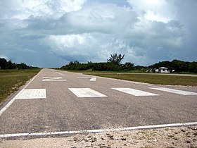
L'aérodrome de Caye Caulker (code IATA : CUK) est un aéroport qui dessert Caye Caulker, Belize. La piste est asphaltée.
Situation
 Belize City (International)  Belize City (National) Caye Caulker Independence/Savannah Punta Gorda Silver Creek |

Compagnies et destinations
| Compagnies | Destinations |
|---|---|
| Belize Maya Island Air[1] | Belize City-P. S. W. Goldson, Belize City (Municipal), San Pedro (Ambregris Caye) |
| Belize Tropic Air | Belize City-P. S. W. Goldson, Belize City (Municipal), Belmopan-Hector Silva, San Pedro (Ambregris Caye) |
Édité le 16/07/2020
Notes et références
- ↑ Maya Island Air website, http://www.mayaislandair.com/belize-flight-schedule
 Portail de l’aéronautique
  Portail du Belize


