North West Leicestershire
Niet-metropolitaans district in Engeland  | |||
|---|---|---|---|
  | |||
| Situering | |||
| Land | Engeland | ||
| County | Leicestershire | ||
| Regio | East Midlands | ||
| Coördinaten | 52°43'1"NB, 1°22'12"WL | ||
| Algemeen | |||
| Oppervlakte | 279,3280[1] km² | ||
| Inwoners (2018[2]) | 102.126 (366 inw./km²) | ||
| ONS-code | E07000134 | ||
| Detailkaart | |||
 | |||
| |||

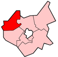
North West Leicestershire is een Engels district in het shire-graafschap (non-metropolitan county OF county) Leicestershire en telt 102.000 inwoners. De oppervlakte bedraagt 279 km².
Van de bevolking is 16,0% ouder dan 65 jaar. De werkloosheid bedraagt 2,4% van de beroepsbevolking (cijfers volkstelling 2001).
Plaatsen in district North West Leicestershire
- Coalville
Civil parishes in district North West Leicestershire
Appleby Magna, Ashby Woulds, Ashby-de-la-Zouch, Bardon, Belton, Breedon on the Hill, Castle Donington, Charley, Chilcote, Coleorton, Ellistown and Battleflat, Heather, Hugglescote and Donington le Heath, Ibstock, Isley cum Langley, Kegworth, Lockington-Hemington, Long Whatton and Diseworth, Measham, Normanton le Heath, Oakthorpe and Donisthorpe, Osgathorpe, Packington, Ravenstone with Snibstone, Snarestone, Staunton Harold, Stretton en le Field, Swannington, Swepstone, Whitwick, Worthington.
Bronnen, noten en/of referenties
|


