Hrabstwo Coös
| hrabstwo | |||
 | |||
| Państwo |
| ||
|---|---|---|---|
| Stan |
| ||
| Siedziba | Lancaster | ||
| Kod statystyczny | FIPS 6-4: 33 007 | ||
| Powierzchnia | 4743,41 km²[1] | ||
| Populacja (2009) • liczba ludności |
| ||
Położenie na mapie New Hampshire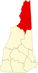 | |||
| 44°41′24″N 71°18′00″W/44,690000 -71,300000 | |||
| |||
| Strona internetowa | |||


Hrabstwo Coös (ang. Coös County, zazwyczaj upraszczane w pisowni do Coos County) – hrabstwo w stanie New Hampshire w Stanach Zjednoczonych. Obszar całkowity hrabstwa obejmuje powierzchnię 1831,44 mil² (4743,41 km²). Według szacunków United States Census Bureau w roku 2009 miało 33 055 mieszkańców[2].
Hrabstwo powstało w 1803 roku[3].
Miejscowości
- Berlin
- Carroll
- Clarksville
- Colebrook
- Columbia
- Dalton
- Dummer
- Errol
- Gorham
- Jefferson
- Lancaster
- Milan
- Northumberland
- Pittsburg
- Randolph
- Shelburne
- Stark
- Stewartstown
- Stratford
- Whitefield
CDP
- Colebrook
- Gorham
- Groveton
- Lancaster
- West Stewartstown
- Whitefield[4]
| Populacja hrabstwa w poprzednich latach[3] | |
|---|---|
| Rok | Liczba ludności |
| 1980 | 35 061 |
| 1990 | 34 828 |
| 2000 | 33 111 |
| 2005 | 33 655 |
Przypisy
- ↑ US Census Bureau: Population, Housing Units, Area, and Density: 2000. [dostęp 2012-05-26]. [zarchiwizowane z tego adresu (2016-03-09)]. (ang.).
- ↑ a b US Census Bureau: Coos County. Quickfacts. [dostęp 2011-07-17]. (ang.).
- ↑ a b National Association of Counties: Coos County, NH. [dostęp 2011-07-17]. (ang.).
- ↑ National Association of Counties: Places in Coos County, NH. [dostęp 2011-07-17]. (ang.).
- p
- d
- e
|


